![]() One
Year By Bicycle
One
Year By Bicycle
|
|
|
|
|
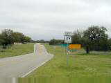
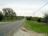
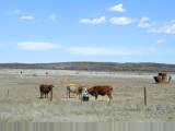
| Population in Terrell County is 976, down from ~3000 or so in the 1950s. | |
| Average home price is $26,000; and average rental is $275. | |
| Nearest traffic signal is 65 miles away. |
85 miles today, 1650 miles cumulative.
 Signs outside Sanderson indicated next services were 66 miles away in daytime
and 120 miles at night. Packed some extra food and water and headed off in
the early drizzle/mist. Fortunately, winds mostly calm and would remain
that way for most of the day.
Signs outside Sanderson indicated next services were 66 miles away in daytime
and 120 miles at night. Packed some extra food and water and headed off in
the early drizzle/mist. Fortunately, winds mostly calm and would remain
that way for most of the day.
Slight descent into Dryden, 20 miles away. The land also opened up a little and no longer followed the canyons as much. Dryden had a single mercantile store. Warmed up inside and had a short talk with the proprietor. Cyclists came through occasionally, as this was only stop for a while. Also a woman on a horse/burro, though probably not the same one I had seen earlier.
 From
Dryden, the terrain had an occasional roll as it went over tops of the land and
ducked into creek canyons as it crossed them. Otherwise, fairly uniform
terrain with lots of mesquite trees and low scrub. Not much variety as I
slowly cycled the next 40 miles to Langtry. Saw a few white tail deer but
not much other wildlife.
From
Dryden, the terrain had an occasional roll as it went over tops of the land and
ducked into creek canyons as it crossed them. Otherwise, fairly uniform
terrain with lots of mesquite trees and low scrub. Not much variety as I
slowly cycled the next 40 miles to Langtry. Saw a few white tail deer but
not much other wildlife.
At Langtry, signs led off to Judge Roy Bean Visitor center. A nice little stop with lore and information about this judge and his brand of justice, "West of the Pecos". A nice cactus garden made for a good excuse to dawdle and rest up.
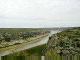
After Langtry decided to continue last 30 miles, crossing the Pecos river
(see above right) before climbing up to the town of Comstock. Another
small town. All three cafes in town were closed for Sunday evening so
simple dinner.
89 miles today, 1739 miles cumulative.
 Rest day today in Del Rio. At breakfast in Comstock, I discovered I'm
close to the boundary of where ice tea is sweetened by default. Actually
wanted hot tea, but that is a different story. Adventure Cycling maps make
this a fairly common route and the cafe proprietors had their own stories of
groups cycling through.
Rest day today in Del Rio. At breakfast in Comstock, I discovered I'm
close to the boundary of where ice tea is sweetened by default. Actually
wanted hot tea, but that is a different story. Adventure Cycling maps make
this a fairly common route and the cafe proprietors had their own stories of
groups cycling through.
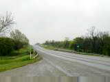
Cool overcast and ~15mph headwinds as I went over some low hills near Comstock and then towards Amistad Reservoir, a popular boating and scuba location. As I cycled the thirty-plus miles to town, slowly traffic increased.
Del Rio is a metropolis of 30,000+. They were hoping for 50,000+ after last census, but apparently fell short. Del Rio is also where I saw my first stop light since Van Horn (>300 miles earlier) and first bike store since El Paso. Purchased and installed a new tire since my rear tire had gone through most of the tread and had an interesting bobble.
Otherwise, a rest day. Chance for laundry, reading and
relaxing. All better than fighting the headwinds for the rest of the
afternoon.
32 miles today, 1771 miles cumulative.
 "In like a lion and out like a lamb?", seems like this March is
lion on both ends with lamb in the middle. Drizzle and headwinds, as I
left Del Rio. The new tire was slightly larger (700x38 vs. 700x35), so
made quite a bit of noise as the little rubber hairs rubbed up against the
fender. Not certain it caused much friction, but the noise definitely was
noticeable.
"In like a lion and out like a lamb?", seems like this March is
lion on both ends with lamb in the middle. Drizzle and headwinds, as I
left Del Rio. The new tire was slightly larger (700x38 vs. 700x35), so
made quite a bit of noise as the little rubber hairs rubbed up against the
fender. Not certain it caused much friction, but the noise definitely was
noticeable.
After five miles, most of the traffic turned off to Laughlin Air Force Base and road became quieter. Still occasional trucks whizzing past and kicking up extra spray to the drizzle. Glasses fogged as I cycled through mostly flat terrain for about 30 miles to Brackettville. On the way, a Border Patrol truck was slowly driving along. He caught up with me at a roadside rest area. Briefly thought about a "buenos dias", but other than counting to ten, don't know much other Spanish. Border Patrol agent mentioned they were ~8000 people and were catching 100s of illegal immigrants each week sneaking across the border. Definitely, saw more of the Border Patrol than and other law enforcement.
At Brackettville, I squished into the local store/cafe. Clerk just looked at me and smiled. I smiled back and we started to laugh. Who would be out cycling in this rain? Had a good breakfast and then headed out Texas 334 destination Camp Wood.
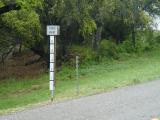
For the next 30 miles, the road had no shoulders. Didn't matter much as less than 10 cars passed in either direction. One was a truck that passed, slowed and stopped. "Do you need a ride somewhere?...or are you doing this for fun?" I assured him I was cycling in the rain for fun. He shook his head and drove on. The route crossed several dry streams. Each was proceeded with a "Warning: Road floods when wet" type signs and then had a local flood gauge as shown above right. Fortunately, no water crossing the road yet.
 After
30 miles, road 334 ended at the junction of 55. The route a little busier
and also with better shoulders. Mostly flat this next stretch.
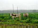
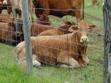
Ranches along both ways with cattle, horses, goats and sheep. The sheep
and goats would generally run as I went past, but the horses and cows just
looked. Some of the ranches had very fancy gates...some money here.
Not certain if it was from ranching or otherwise. However, the vegetation
showed more moisture.
After
30 miles, road 334 ended at the junction of 55. The route a little busier
and also with better shoulders. Mostly flat this next stretch.
Ranches along both ways with cattle, horses, goats and sheep. The sheep
and goats would generally run as I went past, but the horses and cows just
looked. Some of the ranches had very fancy gates...some money here.
Not certain if it was from ranching or otherwise. However, the vegetation
showed more moisture.
Ready for an end of the cycling day when I slowly pedaled
into Camp Wood.
79 miles today, 1850 miles cumulative.
 Texas Hill country is beautiful though tough terrain to cycle through.
Evening before I adjusted my fender and removed some rubber hairs from the tire
so the ride was quieter.
Texas Hill country is beautiful though tough terrain to cycle through.
Evening before I adjusted my fender and removed some rubber hairs from the tire
so the ride was quieter.
Gently climbing terrain for first eight miles and then a steep hill. Surprisingly, since it was hidden around a bend. Slowly climbed up to the ridgeline and then again a bit flatter through the hills. Hills were pretty with trees in many different shades. Still overcast, but fortunately dry.
Rolling terrain across the top of the hills before a quick descent down to Leakey (pronounced Lea-key, not Leak-ey). Over breakfast, met someone who had graduated from same high school as myself, but two years later. Generally friendly folks.
From Leakey, more hilly terrain for next sixteen miles to Vanderpool. Climbed three major hills, with lots of little ones in between. Some steep enough that I jumped off and wheeled the bike up and over. Fortunately, Adventure Cycling maps have some indication of terrain so I knew what to expect. Saw deer several times along the way.
 At
Vanderpool, stopped at the corner market for a lunch and chance to relax.
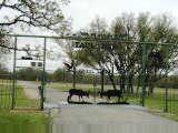
From here headed north along the river before climbing the last big hill of the
day. Walked up most of this one. Along this route were more fancy
ranches. Eight foot fences to keep animals in, and elaborate entrance
gates to impress. Apparently, there is some $ in exotic animals but mostly
the money for these ranches came from elsewhere...corporate CEOs and
others. Perhaps George Bush has a ranch in this type of area.
At
Vanderpool, stopped at the corner market for a lunch and chance to relax.
From here headed north along the river before climbing the last big hill of the
day. Walked up most of this one. Along this route were more fancy
ranches. Eight foot fences to keep animals in, and elaborate entrance
gates to impress. Apparently, there is some $ in exotic animals but mostly
the money for these ranches came from elsewhere...corporate CEOs and
others. Perhaps George Bush has a ranch in this type of area.
After 54
miles, came to intersection of TX 39. Map indicated the route followed
South Fork of the Guadalupe River. However, surprisingly many quick short
hills. I was getting tired and walked a few. Fortunately, the route
eventually flattened out and came in through Hunt to Ingram.
81 miles today, 1931 miles total.

 Mostly quiet backroads cycling through the hill country today.
Occasional raindrops as I left Ingram, but fortunately cleared up and became a
beautiful day. First fifteen miles were a bit busy as I passed through
Kerrville.
Mostly quiet backroads cycling through the hill country today.
Occasional raindrops as I left Ingram, but fortunately cleared up and became a
beautiful day. First fifteen miles were a bit busy as I passed through
Kerrville.
At mile fifteen, turned off on small country lane along the Guadalupe river, Wharton Road. After three miles, it crossed the river on a low dam. Water around three inches deep flowed over the road. Went to take a picture...oops, batteries dead. Got off the bike and walked through ~20ft of river until the other side. Fortunately, other than soaking my shoes, front panniers stayed mostly dry. Three miles later, squished into Center Point store with sign above left for new batteries.
 Nine
miles later, road crossed I-10 at small town of Comfort. Here the road
took quiet back roads through small towns of Waring and Sisterdale. The
terrain was gently rolling. Gentle hills, though when it crossed a stream,
frequently a steep descent, followed by a equally steep climb out the other
side. Still ranches along the way, including one with llamas shown above
right. Apparently, ranches go for ~$3000/acre around here, so a 1000 acre
ranch is for the wealthy here. Otherwise, pretty terrain.
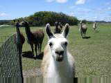
Nine
miles later, road crossed I-10 at small town of Comfort. Here the road
took quiet back roads through small towns of Waring and Sisterdale. The
terrain was gently rolling. Gentle hills, though when it crossed a stream,
frequently a steep descent, followed by a equally steep climb out the other
side. Still ranches along the way, including one with llamas shown above
right. Apparently, ranches go for ~$3000/acre around here, so a 1000 acre
ranch is for the wealthy here. Otherwise, pretty terrain.
Climbed up and
over the last hills along Kendalia before crossing county line and coming into
the small town of Blanco. A fun small town to walk around with a nice
courthouse and also a bowling alley cafe.
69 miles today, 2000 miles cumulative.
 Easy ride today along the Adventure Cycling route. Followed the back
roads south of Austin. No shoulders and surprisingly busy, but otherwise a
good route. The hill country continued to dampen and by end of the day,
was in flat farming country.
Easy ride today along the Adventure Cycling route. Followed the back
roads south of Austin. No shoulders and surprisingly busy, but otherwise a
good route. The hill country continued to dampen and by end of the day,
was in flat farming country.
Mostly overcast again, with an occasional drop, but nothing more than a tease of rain. Leaving Blanco on 165, a small farm road with not much of a shoulder. Quite a few cars zooming past, presumably commuting off to Austin. Land dampened out some, though there were still a few valleys to cross with their sharp declines and hills on the other side. Made good time to Wimberley though.
While cycling one can follow what area one is in by the major newspapers offered along the way. Have been following a police drug corruption sting out of San Antonio the past few days and was still able to get San Antonio papers. However, Houston becoming more prominent as well.
 More
farm road leaving Wimberley, with slightly less traffic. Still farms along
the way, though could tell this was a more urban area as included curbside trash
pickup. A number of smaller "hobby" farms and not as many big
ranches anymore. From Wimberley, 19 miles further was Kyle and a crossing
of I-35. In this area, new subdivisions and home lots for sale. Live
in the country and commute to Austin!
More
farm road leaving Wimberley, with slightly less traffic. Still farms along
the way, though could tell this was a more urban area as included curbside trash
pickup. A number of smaller "hobby" farms and not as many big
ranches anymore. From Wimberley, 19 miles further was Kyle and a crossing
of I-35. In this area, new subdivisions and home lots for sale. Live
in the country and commute to Austin!
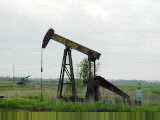
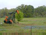
East of Kyle, could tell I was leaving
hill country. The land flattened out and allowed for crops as well as farm
animals. Saw first oil wells as well. Still lots of traffic, and
made a short day today and stopped in Lockhart.
61 miles today, 2061 miles cumulative.
 Meandering roads today following the Adventure Cycling route. As I left
Lockhart at first light, people already busy putting out goods for Saturday
morning flea market sales. Calmer traffic as I headed up TX 20 through
some gently rolling hills towards Bastrop. Lots of wildflowers out today,
bluebonnets and also red flowers, yellow flowers and other blues. Lush
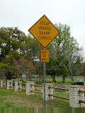
grass and still lots of cattle along the way. Despite what the sign says
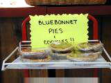
above right, clerk at Rockne grocery told me the bluebonnet pies/cookies don't
really have bluebonnets in them.
Meandering roads today following the Adventure Cycling route. As I left
Lockhart at first light, people already busy putting out goods for Saturday
morning flea market sales. Calmer traffic as I headed up TX 20 through
some gently rolling hills towards Bastrop. Lots of wildflowers out today,
bluebonnets and also red flowers, yellow flowers and other blues. Lush
grass and still lots of cattle along the way. Despite what the sign says
above right, clerk at Rockne grocery told me the bluebonnet pies/cookies don't
really have bluebonnets in them.
Busy traffic outside Bastrop where I merged with TX 71. Fortunately, also a wide shoulder. Not much later cut through the older part of Bastrop before turning off and through Bastrop State Park.
 Next
13 miles through Bastrop and Buescher State Parks were along a peaceful winding
route through pine trees and quiet back roads. The road would twist and
turn, dip and climb around corners. Fun, Saturday morning ride I shared
with quite a few local cyclists.
Next
13 miles through Bastrop and Buescher State Parks were along a peaceful winding
route through pine trees and quiet back roads. The road would twist and
turn, dip and climb around corners. Fun, Saturday morning ride I shared
with quite a few local cyclists.
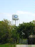
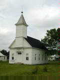
After Buescher park, the route followed 153 for 10 miles to Winchester. Picture above left shows that as the land gets flatter, the water towers are placed on stilts. Picture at right shows the Methodist Church in Winchester. Most churches here are Baptist churches though also see a mixture of Lutheran, Methodist and Catholic churches. Definitely in the bible belt here.
Winchester store was closed, but fortunately found a nice small store/restaurant (Hajek's) at intersection of 153 and US 77. Good lunch and chance to get road information from the patrons. Route headed south last seven miles to La Grange along busy US 77. Shoulders again and first rumble strips for a while.
No room at the inn. Oak Motel was full, due to Antique festival. We called to the other motel and made a reservation. As I cycled out to the motel, found out there were actually three other motels and I hadn't thought to ask which one. Went to all three and found my room at the third one.
So far have
been enjoying this first month on the road. Definitely some interesting
contrasts as I head slowly eastwards across the US.
72 miles today, 2133 miles cumulative.
![]()
![]()
|
Unless otherwise specified, this page © Copyright 2001-2002, Mike Vermeulen |
 Easy ride today. Rear bicycle tire appears to have a very slow
leak. Tried riding by three bike stores in town, but unfortunately missed
the first address, second wouldn't be open for three hours and third wouldn't be
open. Have enough stuff, but will just see what happens here.
Easy ride today. Rear bicycle tire appears to have a very slow
leak. Tried riding by three bike stores in town, but unfortunately missed
the first address, second wouldn't be open for three hours and third wouldn't be
open. Have enough stuff, but will just see what happens here.
 Today started riding along the Rio Grande on quiet back roads past McNary and
then Esperanza. The latter consisted of half a dozen houses and the former
even fewer. Some crops in fields, though early in the season to see
exactly what. Several canals as this definitely relies on irrigation.
Today started riding along the Rio Grande on quiet back roads past McNary and
then Esperanza. The latter consisted of half a dozen houses and the former
even fewer. Some crops in fields, though early in the season to see
exactly what. Several canals as this definitely relies on irrigation.
 Dry, desolate and mostly flat terrain. Perhaps foreshadowing
Australia? Left town before sunrise and headed south on US-90. My
"at least" milestone was Marfa 78 miles from start. I had
brought enough water to make it all the way, though thought perhaps there might
be something at Valentine half way.
Dry, desolate and mostly flat terrain. Perhaps foreshadowing
Australia? Left town before sunrise and headed south on US-90. My
"at least" milestone was Marfa 78 miles from start. I had
brought enough water to make it all the way, though thought perhaps there might
be something at Valentine half way.
 Windy overcast day in West Texas. Fog starting out as I left Alpine,
not quite drizzle but pretty close. Slow riding without much to see as I
followed the railroad tracks out of town. About half a dozen freight
trains total today.
Windy overcast day in West Texas. Fog starting out as I left Alpine,
not quite drizzle but pretty close. Slow riding without much to see as I
followed the railroad tracks out of town. About half a dozen freight
trains total today.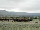 Skies
cleared slightly. First eighteen miles were mostly level, but from there
dropped 1500ft which helped some against the wind. Wild flowers reappeared
along the route, yellows, purples and a few reds. Cows along the way would
get curious, perhaps wondering what funny cow my bicycle was. Saw a herd
of buffalo, seen above left that were also curious. Also saw three
Antelope grazing by the road.
Skies
cleared slightly. First eighteen miles were mostly level, but from there
dropped 1500ft which helped some against the wind. Wild flowers reappeared
along the route, yellows, purples and a few reds. Cows along the way would
get curious, perhaps wondering what funny cow my bicycle was. Saw a herd
of buffalo, seen above left that were also curious. Also saw three
Antelope grazing by the road.