

May 1st-10th, 2001
May 1st; (today was lost across the date line)
Map 01
May 2nd;
Sydney to Mount Ku-Ring-Gai
 Australia at last! Bicycle and luggage arrived safely. Customs
was carefully checking for "hoof and mouth" disease and asked everyone
which countries they had been in and whether they had left cities for
countryside or farms.
Australia at last! Bicycle and luggage arrived safely. Customs
was carefully checking for "hoof and mouth" disease and asked everyone
which countries they had been in and whether they had left cities for
countryside or farms.
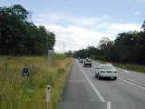
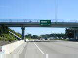
Two challenges with today's short 45km ride. Cities always take a
little more concentration and Sydney has four million residents (over 20% of the
population of Australia). Riding on the left took a little getting used
to, though not too hard. Doing both of these in a new country after a long
flight was fun.
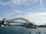
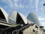
Airport is 10km south of town. A busy route with not much shoulders,
though traffic was at least as polite as USA. Once I reached downtown, I
became a pedestrian and walked through downtown and obligatory stop at the Opera
House (my designated start/finish line). Hope to explore further on the
next lap. Already seen some nice botanical gardens.
 Following
the Pacific Highway outbound via Chatswood and Hornsby. This route was
about two and a half lanes, meaning the left bicycle lane sometimes disappeared
and sometimes had parked cars. Rolling terrain, with a few slightly steep
hills. Route followed the commuter train to the northern suburbs of
Sydney. Wooded terrain as slowly left the city behind.
Following
the Pacific Highway outbound via Chatswood and Hornsby. This route was
about two and a half lanes, meaning the left bicycle lane sometimes disappeared
and sometimes had parked cars. Rolling terrain, with a few slightly steep
hills. Route followed the commuter train to the northern suburbs of
Sydney. Wooded terrain as slowly left the city behind.
Decided on a short day to adjust to the time and also get communications
working again. mev@pocketmail.com.au
will be the best address for a while.
45 km today, 5325 km cumulative.
May 3rd; Mount Ku-Ring-Gai to Newcastle
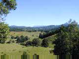
 Beautiful day cycling northwards, around 17 Celsius (63 F) and dry despite a
forecast of 75% showers. First part of the route was on 83 running
parallel to the main freeway #1 and hence light traffic and most of it going
towards Sydney. Some rolling hills and an overall climb out of the Sydney
drainage before a nice descent to the Hawkesbury river. Here began 26km of
"Scenic Route", starting with a climb back up to the tops of the
hills. Saw several local cyclists, and also road markings from cycle
events. Bike route signage contributed to overall sense of this being a
popular cycle route. Most of the surrounding hills were part of Brisbane
Water National Park and hence undeveloped.
Beautiful day cycling northwards, around 17 Celsius (63 F) and dry despite a
forecast of 75% showers. First part of the route was on 83 running
parallel to the main freeway #1 and hence light traffic and most of it going
towards Sydney. Some rolling hills and an overall climb out of the Sydney
drainage before a nice descent to the Hawkesbury river. Here began 26km of
"Scenic Route", starting with a climb back up to the tops of the
hills. Saw several local cyclists, and also road markings from cycle
events. Bike route signage contributed to overall sense of this being a
popular cycle route. Most of the surrounding hills were part of Brisbane
Water National Park and hence undeveloped.
83 crossed the freeway for the last time, and headed off towards Gosford.
Several of these towns have a "Shopping Centre" consisting of many
small shops and Gosford was no different. Found a pastry shop next to a
fruit shop...definite place for cyclists. Gosford also had a small harbor
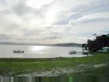
with mostly pleasure craft.
 From
Gosford, the road became busier and headed over a small ridge and back towards
Terrigal, Bateau Bay and finally a town known as The Entrance. A good
lunch stop here. The entrance itself appears to be a narrow opening from
the sea to Tuggerah Lake. On the north side of the opening, the terrain
flattened out considerably as it went between lake and sea. Signage showed
distance to Newcastle. This region is known as the Central Coast.
Also crossed Wyrrabalong National Park and stopped briefly at display showing
flora and fauna.
From
Gosford, the road became busier and headed over a small ridge and back towards
Terrigal, Bateau Bay and finally a town known as The Entrance. A good
lunch stop here. The entrance itself appears to be a narrow opening from
the sea to Tuggerah Lake. On the north side of the opening, the terrain
flattened out considerably as it went between lake and sea. Signage showed
distance to Newcastle. This region is known as the Central Coast.
Also crossed Wyrrabalong National Park and stopped briefly at display showing
flora and fauna.
Two power plants here. Next kms went across a ridge before descending
to Swansea. From here, last 27kms were considerably busier. Made my
way through center of Newcastle and found a place to stay.
I'm getting more used to riding on the left and have even done enough
roundabouts to feel comfortable there.
137 km today, 5462 km cumulative.
May
4th; Newcastle to Bluey's Beach (24km south of Forster)
 Another beautiful day riding with a variety of different road conditions and
terrain. Newcastle claims title to be the sixth largest city in Australia
(Sydney, Melbourne, Brisbane, Perth and Adelaide all have over a million people,
Canberra might also be larger). Rode along the Hunter River and also past
the industrial parts of the city.
Another beautiful day riding with a variety of different road conditions and
terrain. Newcastle claims title to be the sixth largest city in Australia
(Sydney, Melbourne, Brisbane, Perth and Adelaide all have over a million people,
Canberra might also be larger). Rode along the Hunter River and also past
the industrial parts of the city.
Pacific Highway joined Route #1, crossed the Hunter River and headed
northbound. For the first 33km on this route, the road was a divided
highway with two lanes each way, a wide shoulder and flat. Some eucalyptus
trees, some ranches with cattle and also signs pointing to an airbase in the
area. The kms quickly passed in the flats and was in Karuah around nine.
Several "roadhouses" and a good place to stop for a break.
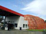
From Karuah, the route became a single lane each way with an occasional
overtaking lane. These were mixed blessings as they usually coincided with
hills. About 16km from town was a tourist stop made to look like Ayers
Rock. Too intriguing to pass, a quick stop and picture.
 The
road continued to bounce around and landscape became more open as I reached
Bulahdelah. Nice main street with multiple motels and nice visitor
center. This region is known as the Great Lakes region for several
oceanside lakes.
The
road continued to bounce around and landscape became more open as I reached
Bulahdelah. Nice main street with multiple motels and nice visitor
center. This region is known as the Great Lakes region for several
oceanside lakes.
Three kms past Bulahdelah, left the highway on a small bumpy two lane road
that curved out to the coast. The route started with a long steep
climb. As I slowly climbed the hill, was amused to see a sign tacked on a
tree, "loose 5-10 kilos". These signs are international!
Climb followed by a quick descent, mostly limited by the bumpiness of the
road surface. At bottom a turnoff to the tallest tree in NSW. Level
for a while and then another long climb. This one interrupted by road
construction, flagman and single lane of traffic. I tried to cycle uphill
on the dirt as quickly as I could, but still got a few cars behind.
Fortunately, construction quickly ended and drivers were polite.
More forest as I neared Bungwahl, eucalyptus, pine trees with long needles
and a few other plants. Multiple sharp hills made a contrast with start of
the day. Ready for a stop at Bluey's Beach.
Australia isn't completely metric. Quite a few vacation homes for sale,
typically listed as acres not hectares. Late lunch at takeaway.
Portions of chips are very generous here. Also noticed pickled beet
instead of pickles on burgers here.
142 km today, 5604 km cumulative.
May 5th; Bluey's Beach to Port Macquarie
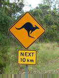
 Saw
my first live kangaroo today. Hopping alongside the road as I left Bluey's
Beach. Peaceful early morning ride along Lake Wallis. Came through
Booti Booti National Park and into towns of Forster and Tuncurry. Got
breakfast and learned from the paper who won 'survivor II'. Papers here
have fun poking fun as things that aren't quite realistic for the outback.
Saw
my first live kangaroo today. Hopping alongside the road as I left Bluey's
Beach. Peaceful early morning ride along Lake Wallis. Came through
Booti Booti National Park and into towns of Forster and Tuncurry. Got
breakfast and learned from the paper who won 'survivor II'. Papers here
have fun poking fun as things that aren't quite realistic for the outback.
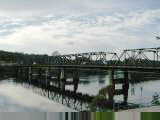
A narrow opening from Wallis Lake to the sea separates the two towns and is
crossed by a bridge. On the other side, route was considerably flatter and
unfortunately also busier. After 9kms, most other traffic took the more
direct route to the Pacific Highway. I rejoined about 11km further.
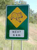
Back on the divided highway. This section had Koala Crossing caution
signs. After 13km, a turnoff to Taree that I rode through town.
Saturday morning with a bustling downtown centre. Outside town, sports
fields with plenty of soccer moms/dads to watch.
From Taree, back to narrow double lane highway. Flat, open countryside
with ranches. Crossed a narrow bridge to Coopernook. Town consisted
of not much more than hotel, service station and antique barn. Road
continued narrow and rolling hills into Kew. Stopped at the Kew visitor
info center. Got info about road conditions, Australian history and
shires/districts and other administrative governmental units. Apparently,
the 100th anniversary of the 1st Australian Parliament is coming soon.
 Met
three other touring cyclists on the next stretch. A couple who had ridden
from Adelaide and a young man heading from Sydney to Brisbane. The first
couple had a front tire with a bad bobble. Divided highway with broad
shoulders brought me to the Port Macquarie turnoff.
Met
three other touring cyclists on the next stretch. A couple who had ridden
from Adelaide and a young man heading from Sydney to Brisbane. The first
couple had a front tire with a bad bobble. Divided highway with broad
shoulders brought me to the Port Macquarie turnoff.
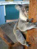
Took a brief detour to a koala park tourist attraction. Held a koala
bear (support them firmly from below or else they climb higher). Saw emus,
kangaroos and other native wildlife. After playing tourist, cycled the
last 11kms into center of town.
139 km today, 5743 km cumulative.
Map 02
May 6th; Port Macquairie to Nambucca Heads
 Rain showers overnight, but fortunately almost ended when I started
out. Evening before, had stopped at an internet cafe and gotten a
description of IT industry in Australia (no DSL/cable modems yet, center is
Sydney with some stuff in Melbourne and Brisbane).
Rain showers overnight, but fortunately almost ended when I started
out. Evening before, had stopped at an internet cafe and gotten a
description of IT industry in Australia (no DSL/cable modems yet, center is
Sydney with some stuff in Melbourne and Brisbane).
Followed the Hastings River back to the Pacific Highway to continue
northwards. Forests and rolling hills. Frequently as one crosses
into a new cachement (drainage basin), a sign gives the name as well as area in
square kms. A few houses at Telegraph Point and Kundabung, but not much
until Kempsey.
Kempsey was a little busier, though most shops were closed on Sunday
morning. I had been told this town had a concentration of aboriginal
people but didn't particularly notice. Crossed the river and stopped
briefly at far side of town.
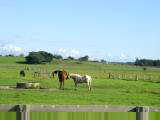
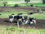
 Next
25kms or so were flat open pastures with cows and horses. It is
fall, though the land is still nice and green and some flowers are
blooming. Expect that it rarely freezes here.
Next
25kms or so were flat open pastures with cows and horses. It is
fall, though the land is still nice and green and some flowers are
blooming. Expect that it rarely freezes here.
At the Clybucca roadhouse, met a cyclist coming from Brisbane and going to
Sydney. Traded info about the road, though he'd mostly been avoiding the
Pacific Highway for quieter routes. Cycle touring is definitely popular
here.
From here, crossed into the Nambucca cachement with a few more hills.
This part of the route seems to have occasional roadside rest areas. A
campaign with big signs saying, "Every Two Hours;
Stop/Revive/Survive". Good excuse to stop on bicycle as well.
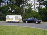
Talked with couple going around Australia in 4.5 months, but driving with a
trailer. Trailers seem to be more popular and haven't seen the really
large American style RV.
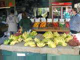
Last kms into and through Mackville, the road shoulders became
narrower. Several roadside fruit stands selling bananas (AUS $ 0.95/kilo
or around 25 US cents/pound), macadamia nuts (AUS $3.00/kilo) and others.
Rugby match going on at Mackville. Nambucca Heads looked like a nice place to
stop for the day, so stopped.
Palm trees, noisy parrots, banana trees, quiet Sunday traffic. Tonight
an important rugby match between Queensland and New South Wales. Will have
to find a pub and watch a little of the game (and a little of the crowd) before
bedtime.
111 km today, 5854 km cumulative.
May
7th; Nambucca Head to Woolgoolga
 Maroons win! Queensland decisively defeated New South Wales in rugby
34-16. After being up 34-4 at one point. Patrons in the pub were
subdued. I left before the end of the game.
Maroons win! Queensland decisively defeated New South Wales in rugby
34-16. After being up 34-4 at one point. Patrons in the pub were
subdued. I left before the end of the game.
Today weather and mechanical problems made for a shorter day. On verge
of rain starting out with even more menacing crowds on the horizon. Big
hill to climb in Nmbucca before reaching the Pacific Highway. Wooded
terrain, apparently some of the largest eucalyptus logging areas nearby, though
surprisingly few truck. Rolling hills this first stretch.
Cresting a hill about 18kms into the ride, I rode over a twig and suddenly
noticed something wrong with the drive train on the bike. Got off and
figured out the rear cassette was locking up and not rotating backwards
easily. When applying power to the pedals, this isn't a problem.
However, the cassette normally spins freely when coasting, e.g. going
downhill. As I coasted, extra chain would accumulate on top and hang in
way of the wheels, etc. It was obnoxious, though fortunately rideable.
I assessed the situation. Coffs Harbour was 32km away and had 60,000
residents. As long as I didn't coast much, I could cycle there.
Definitely made for an interesting ride. For example, going downhill I
applied my brakes so that I could cycle downhill and still apply power to the
pedals. Slowly headed off to the city.
Surprisingly many hills, and I noticed them all!, as I came through forest
and parts of Urunga, Bonville and Sawtell. Busier traffic. Stopped
at the info centre and found addresses for three bike stores. Cycled to
the first. The owner/mechanic had another bicycle to finish first and said
I could come back after noon (>2 hours later).
 Went
for a walk through downtown Coffs Harbour. Bought a new pair of shoes (old
ones almost falling apart), had lunch and stopped at an internet cafe.
Went
for a walk through downtown Coffs Harbour. Bought a new pair of shoes (old
ones almost falling apart), had lunch and stopped at an internet cafe.
After lunch, the bike shop had diagnosed the problem as the rear cluster
falling apart. Three pins hold the gears together and one had slipped
inwards where it jammed against the wheel. Haven't seen that failure
before...most likely a defect in the original cluster. Don't think the
twig I rode over had much to do with it, though not certain why things broke
where they did.
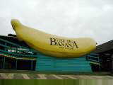
Gathered my gear back on the bicycle and started down the road. Felt
nice to be able to coast again! Coffs Harbour claims to be the largest
banana harbour in the world and I saw many banana plants. Some had bags
covering the bundles. Also, some nice tourist resorts along the way.
Still busy traffic with some rolling hills.
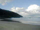
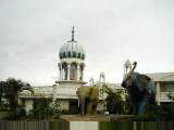
After 23kms, came to Woolgoolga. This town has a large Sikh temple,
some Indian restaurants and a few motels. Not long after I stopped, it
started to pour. Lucky I hadn't tried for my original destination of
Grafton which I probably wouldn't have made before dark.
72 km today, 5926 km cumulative.
May
8th; Woolgoolga to Broadwater
 Today a little flatter and also a longer day. It had rained heavily the
previous evening and night. I never saw a report, but wouldn't be
surprised at 3-5 cm of rain. Fortunately, it was mostly stopped as I
started out. I frequently buy some breakfast items the afternoon
before. The little refrigerator had solidly frozen my yogurt (tastes just
like you buy!), an orange and a slice of cake.
Today a little flatter and also a longer day. It had rained heavily the
previous evening and night. I never saw a report, but wouldn't be
surprised at 3-5 cm of rain. Fortunately, it was mostly stopped as I
started out. I frequently buy some breakfast items the afternoon
before. The little refrigerator had solidly frozen my yogurt (tastes just
like you buy!), an orange and a slice of cake.
First 12 km or so were still following the coast, though never saw ocean with
all the trees. From here it turned inland and over the Dirty Water
range. Wooded and not much signs of people other than the road.
Halfway Creek had a roadhouse where I stopped briefly. From here through
the woods on to Grafton at km 56 for the day.
Grafton had a nice info center and a McDonalds to get breakfast. I
bypassed the main center of town. Road shoulders continued mostly
reasonable. From Grafton, the route was mostly flat as it followed the
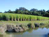
Clarence River for ~50km through Ulmarra, Cowper, Tyndale and Maclean. Saw
cows, horses and a few sheep. For the first time on this route also saw
sugar cane. Also hay, corn and signs for bananas. Flat terrain and
tailwind helped kilometers pass quickly.
 After
100km for the day, crossed over the Clarence River shipping channel to
Harwood. Signs indicated a sugar mill and surrounding areas were mostly
cane. From here another 8 km of flat and then crossed another branch of
the Clarence River.
After
100km for the day, crossed over the Clarence River shipping channel to
Harwood. Signs indicated a sugar mill and surrounding areas were mostly
cane. From here another 8 km of flat and then crossed another branch of
the Clarence River.
The next 40 km went through wooded terrain with no side roads.
Occasional overtaking lanes and ok shoulders. I was starting to slow as I
tired. Took a turnoff for "Little Italy". Little Italy had
a museum and craft area of Aboriginal art. Also two museums celebrating
Italian immigrants in the region as well as their horrible journey in 1880 to
what had been sold as paradise. About a third of these immigrants died on
the way or after arriving in the jungle. Fortunately, found their way to
Sydney and then back to settle in northern NSW.
After Little Italy, followed the Pacific Highway the last 20 km, past town of
Woodburn and into Broadwater. Ready for a stop.
161 km today, 6087 km cumulative.
Map 03
May
9th; Broadwater to Tweed Heads
 Happy Birthday Australia! Today marks the 100th anniversary of the
opening of the first parliament in Australia, one of the important events in
federation of Australia. Prior to that, all the separate Australian
colonies reported separately to Britain. Overall, this year is the 100th
anniversary of the federation as a separate nation as part of the British
commonwealth. It is a little unclear to me what events are most important,
but May 9th was an important step.
Happy Birthday Australia! Today marks the 100th anniversary of the
opening of the first parliament in Australia, one of the important events in
federation of Australia. Prior to that, all the separate Australian
colonies reported separately to Britain. Overall, this year is the 100th
anniversary of the federation as a separate nation as part of the British
commonwealth. It is a little unclear to me what events are most important,
but May 9th was an important step.
Mixed terrain with a surprising amount of hills today. Flat starting
out from Broadwater as the route followed the Richmond River through Wardell to
Ballina. Still sugar cane area. Surprising number of trucks and
small shoulders meant I kept vigilant.
 Ballina
a fairly large town with multiple motels. For the next stretch, I decided
to go off the Pacific Highway and follow the coast road to Byron Bay.
After a flat stretch, I was rewarded with several hills to climb over.
Town of Lenox Head nestled in an inlet. Byron Bay was definitely an
upscale tourist town. Nice vacation places for families but also lots of young
adults with backpacks wandering around. Apparently, the hitchhiking symbol
is an extended finger, not thumb.
Ballina
a fairly large town with multiple motels. For the next stretch, I decided
to go off the Pacific Highway and follow the coast road to Byron Bay.
After a flat stretch, I was rewarded with several hills to climb over.
Town of Lenox Head nestled in an inlet. Byron Bay was definitely an
upscale tourist town. Nice vacation places for families but also lots of young
adults with backpacks wandering around. Apparently, the hitchhiking symbol
is an extended finger, not thumb.
After Byron Bay, was happy to make my way back to the Pacific Highway.
Next stretch had significant road construction, apparently a bypass. Some
rolling hills that were steep enough to get me in low gears. A little
descent and to the hamlet of Mooball.
 The
Moo Moo cafe was overflowing with black and white spotted cow motif/theme.
For example, they served brekky (breakfast) all day and included Moo-Moo pads as
their name for pancakes. A nice place to stop before climbing over the
Burringbar Range of hills. More low gears.
The
Moo Moo cafe was overflowing with black and white spotted cow motif/theme.
For example, they served brekky (breakfast) all day and included Moo-Moo pads as
their name for pancakes. A nice place to stop before climbing over the
Burringbar Range of hills. More low gears.
Eventually made it to Murwillumbahm where it became flatter again along the
Tweed River. A lot of the houses are built up off the ground, even when
little damage of flooding. Not certain why, perhaps to lessen pests?
Followed the river downstream. Road became busier and also wider as I
came to Tweed Heads. Seemed like a good place to stay and found a place in
town. From here, walked to the Queensland border and got an obligatory
photo of the border and also one with a foot in NSW and a foot in Queensland.
132 km today, 6219 km cumulative.
May
10th; Tweed Heads to Middle Park (suburb of Brisbane)
 Today busy riding on congested roads as I got close to Brisbane. Across
from the motel in Tweed Heads is a "bowling club". Far as I can
tell, these clubs have limited forms of gambling and not much bowling.
Today busy riding on congested roads as I got close to Brisbane. Across
from the motel in Tweed Heads is a "bowling club". Far as I can
tell, these clubs have limited forms of gambling and not much bowling.
I was within 600m of the Queensland border and quickly crossed to Coolangatta,
another beach and resort town. I followed the road back to the Pacific
Highway but then exited a few kms later on the main road through the Gold Coast
region.
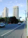
The Gold Coast is a busy commercial strip. Reminds me a little of Miami
Beach in Florida with beaches, high-rises and tourist attractions. This
Gold Coast even has towns named Miami and Palm Beach. The main road was
busy, though frequently had a bus lane that was reserved for buses, taxis,
bicycles and turning/merging traffic. Unfortunately, quite a few lights to
stop along the way. I didn't see much of the beach since it was hidden
behind the high-rises.
After 30kms or so, followed the highway back from the coast and to the
Pacific Highway. Signs indicated Brisbane at approximately 60km. By
now, the highway was a busy motorway with four lanes of high speed traffic and
busy exits. Pedestrians, animals and tractors were prohibited. The
space where bicycles would have been listed was conspicuously pasted over.
For the next 20+ km I rode on the side of this high speed highway towards
Brisbane. It took some care at the exits to cross with merging/exiting
traffic. Each of these exits would list major businesses. The
combinations were sometimes a bit strange, e.g. Pie Company & Crematorium
& Drive-in Theatre.
 When
I reached Beenleigh, I was in range of my metropolitan Brisbane map and also had
enough of the motorway. From here, I picked up smaller highways for
another 40km to Middle Park. It was fun taking one road for a few km and
then another. Traffic was moderately heavy and shoulders variable.
However, good cycling compared with other cities over a million population I had
cycled through. Rolling hills meant I had to occasionally shift down and
grind up a hill. For the final bit, it took some urban navigation and a
few questions, but I eventually found my way to Rob and Becky's, friends of a
friend who I had been in contact with and who were gracious about having me stay
a night in Brisbane.
When
I reached Beenleigh, I was in range of my metropolitan Brisbane map and also had
enough of the motorway. From here, I picked up smaller highways for
another 40km to Middle Park. It was fun taking one road for a few km and
then another. Traffic was moderately heavy and shoulders variable.
However, good cycling compared with other cities over a million population I had
cycled through. Rolling hills meant I had to occasionally shift down and
grind up a hill. For the final bit, it took some urban navigation and a
few questions, but I eventually found my way to Rob and Becky's, friends of a
friend who I had been in contact with and who were gracious about having me stay
a night in Brisbane.
105 km today, 6324 km cumulative.