![]() One
Year By Bicycle
One
Year By Bicycle
|
|
|
|
October 21st-31st, 2001October 21st; Mount Ebenezer to Erldunda Roadhouse
From here it is 201 km to Alice Springs with a nice stopping point just past halfway point. Winds picking up from North and some extra time, meant I decided to make an easy day and stop at Erldunda. Erldunda is a large roadhouse with many coaches and cars stopping on their way to Uluru. The roadhouse has motel, caravan park, restaurant, laundry, internet station and a fauna park with emus and kangaroos. Water for the park comes from bores 20 km and 5 km away and they use 86,500 liters per day. Three diesel generators are used to generate power. About 25-30 staff live on the premises.
October 22nd; Erldunda Roadhouse to Stuarts Well
Slight rise leaving Erldunda followed by slight descent 10 km later and more long wavelength hills after that. Mostly trees along the way though in some areas one could see for far distances. Some nice rock outcroppings at 60 km and also at 80 km. Rest areas with water tanks at 33 km and 74 km though I didn't stop there today. Nice riding northbound, with occasional rain showers. At 70 km I came past turnoff to Kings Canyon (160 km including 100 km unsealed, caravans not recommended). Also nearby was the Henbury Meteorite park (15 km), though from what I understand the meteorite fragments themselves have been moved. Speaking of meteorites, evening skies in NT are just wonderful. Many stars in the sky and the milky way is usually clearly visible. Many evenings I also see some falling stars, beautiful!
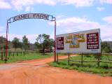
This area was first called Doctor's Stones because Stuart's tri doctor, Dr FE Renner left his medical kit here. It was renamed Stuart's Well in 1981 after several businesses moved here. The name marks the fact that Stuart dug for water in the dry Hugh River during his 1861 expedition (in 1860 there had been plenty of surface water). There is a roadhouse (Jim's Place) with restaurant and motel. There is also a camel farm. Noel Fullerton moved his camel farm here from Alice Springs in 1980. Noel was the one who started the camel races in Alice Springs in 1970. I wandered over and looked at the camels. In the evening, plan is to replace the front tire. Looks a bit too scary to
coax it the last distance to Alice Springs. October 23rd; Stuarts Well to Alice Springs
Overnight several storms passing through. I'm seeing a lot of rain for a desert region. I'm told when it does rain, it usually comes down hard. These showers fit this pattern as well. It rains very hard, but 15 minutes later storm is past and dry again. No power this morning, generators are turned off between midnight and six AM. Gather my stuff together and I'm off riding in the cool morning air. A few low ranges of hills to cross, but generally pretty flat and I make quick progress. More scrubby trees along the way. My replaced front tire is riding well (this is the original tire that came with the bike, so six years old but still with enough tread).
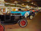
Just past the airport is turnoff to the Ghan Railway museum and Motor Transport Hall of Fame. I ride out and see both museums. The original railway was started in 1877 as a broad gauge line from Port Augusta to Marree. It was extended as a narrow gauge line to Oodnadatta in 1884. It took a while, but eventually by 1929 the narrow gauge line was extended across the flood plains to Alice Springs. While rains were rare, it was moderately often that tracks were simply washed away. The original Ghan was notorious for being delayed. Eventually a standard gauge was built further west on a more stable base in 1980. Trains can travel at twice the speed. It is these tracks I'll ride on Friday. The Road Transport Hall of Fame had the expected trucks and outback vehicles as well as photos. What was intriguing to me was how recent this all developed. Until 1987, much of the freight could come by rail from the south, so roads northbound were sealed but southbound were still unsealed. After visiting the museums, I rode the last 10 km into town. Several large rock outcroppings around town, Alice Springs itself is a bit of a valley. Found a backpacker motel not far from the Todd Street Mall downtown. Made an appointment to have my bike checked and purchased another tire. Wandered around town and climbed up the ANZAC Hill memorial to look over town. Met three more touring cyclists, heading from Adelaide to Darwin. One had a trailer with flexible solar panel made from flexible material used on sails. Nice to be in a moderate sized town again. Accommodation is more
expensive, network access is better, more shops and places to look around.
I'll spend some time looking around here and relaxing. October 24th; Rest day in Alice Springs
After breakfast I brought my bike to the Penny Farthing bike shop. From there I walked another 3 km north to the old telegraph station.
The line was built "on the cheap", the gum tree wooden poles were quickly eaten by termites and cypress pine poles were dry and susceptible to fire. Hence within a few years of construction the linemen started replacing poles with iron which took another ten years. Also over time copper wire replaced galvanized (sounds like a software project). Charles Todd's wife was named Alice. Nearby is a waterhole in the Todd River, named Alice Springs. Originally the nearby town was named Stuart and telegraph station and post office 4 km north was Alice Springs. When the telegraph station was moved to town in 1932, the town was changed to Alice Springs. The telegraph station had well preserved stone buildings and descriptive signs. It was nice to walk along the river back to town.
Took a shuttle bus back to Alice Springs and had a little more time to look
around town. October 25th; Rest day in Alice Springs
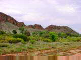
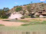
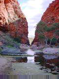
Emu Run had a small van pickup at 7:45. Fellow passengers from Germany, Poland, Japan, Britain and Australia. This company has recently started by Wayne and Denise who were along on the trip. First stop was John Flynn's grave. Flynn started Royal Flying Doctor Service, so vital to the bush. His grave is marked by one of the "devils's marbles". The Devil's Marbles are a unique rock collection from ~500 km further north. Next stop was Simpsons Gap, a dramatic cut in the range with Roe Creek in the middle. Several rock wallabies were hopping along the side.
We stopped at the ochre pits. Ochre deposits formed color base for rock paintings and thus were prized by aboriginals. The ochre puts had surprising variety of colors in many different color layers. We had lunch at Ormiston Gorge. This large 2 km long gorge had long red wall and water holes in bottom of the gorge. We went for longer hike in this gorge, one direction along the gorge walls and back along the base. After Ormiston Gorge, we stopped at Glen Helen. Glen Helen was a former cattle station, now restored as a tourist hotel/restaurant/campground. The Finke River went through a gorge here. The Finke River has followed the same course for 100 million years and thus is claimed to be the oldest river in the world. From Glen Helen we headed back. On way back we stopped at Ellery Creek Big Hole. This was another large swimming hole and small gorge behind. Overall a relaxing day with several short hikes, half a dozen gorges. Got a good sense of highlights of the west MacDonnells. Emu Run did a good job with the tour. In the evening I spent some time at the internet cafe and was able to send
out some of the photos to the web server. October 26th; The Ghan to Port Augusta
I cycled to the train station. It was full of passengers from the recently arrived train. Rows of tour buses and courtesy shuttles from different accommodation awaited the passengers. I dropped off my bike and then walked back to the supermarket to get some food for the train. We boarded about 12:30 pm and the train left promptly at 1 pm.
It was interesting to ride back along a similar route to what I had cycled. I could see broad stretches of scrub, but then also recognize small landmarks from cycling. Met several Americans on the train, overhead Dutch being spoken several times and also met Australian and Slovak tourists. Good chance to read. Bill Bryson's book and the Lonely Planet Australia seemed popular amongst tourists. I'd read both so was reading "The Ghan" by Basil Fuller. A brief stop at Kulgera. After dark one stop for Coober Pedy and then overnight riding to Port Augusta. Unlike reputation of pre-1980 Ghan, we were running ahead of schedule. I've definitely enjoyed the three week detour back to the outback and the
Northern Territory. In addition to beautiful wide open spaces, Cooper
Pedy, Uluru, Kata Tjuta, Alice Springs and the Ghan have been good reasons to
travel along this way. So far my favorite regions have been (1) Top End,
(2) Kimberley and (3) Central Australia...though plenty of other places I've
enjoyed and recommend as well. October 27th; Port Augusta to Port Pirie
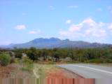
At 5 am I cycled from the train station and rode one lap through downtown. Nothing was open, so I rode out of town to a McDonalds and waited for it to open at 6 am. After brekky and reading the newspaper, I was off again, hooray! South side of Port Augusta looked industrial and even had waste ponds with foam. After that back to saltbush and low scrub. The road was paralleled on one side by a water line and on the other by the railway. Otherwise mostly flat terrain with the Flinders Ranges rising to the left and Spencer Gulf in the distance to the right. Road trains are back to double trailers at maximum.
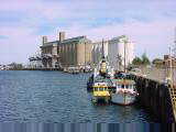
Port Pirie has 15000 people and has been an important port for sending both
minerals and agricultural produce by sea. At one point the town had three
different gauges of rail coming into town. At one end of the harbor is a
large zinc and lead smelter. At the other end a large grain silo.
There is a wide main street with ornate old buildings and an abundance of signs
marking places where buildings once stood. One gets the feeling that Port
Pirie was once even more important and has declined a bit recently. October 28th; Port Pirie to Port Wakefield
The weather forecasts had me worried, 25 knots from the SW and morning rain showers. I was thus happy to find lighter winds and no rain. For my route today I decided to take back roads via Port Broughton instead of the main highway #1. The person at the motel had explained it was "only 20 minutes longer", this by car of course. Left Port Pirie through residential areas. Looking over the roofs were many tall antennas. Must be just close enough to get Adelaide stations with an eight meter antenna. At 10 km was a monument in shape of a bell. A few kms further someone was herding sheep with a ute truck and a dog. Somehow was much less graceful than on horseback. At 25 km I came to crossroads marked Wandearah East. Signs indicated former post office. Here and several other places along the way were abandoned stone buildings. Got the sense that farms had been consolidated into large sizes leaving behind former houses. A few gentle hills and I was into Port Broughton at 56 km. Port Broughton was cute small town with main street, shops, motel, town jetty and WWI memorial. I read somewhere that during WWI Australia lost more soldiers in proportion to population than almost every other country. Surprising given distance from Europe. I talked with a farmer from the area. He grows wheat, barley, hay and other crops. The wheat is just turning and will be ready to harvest in three weeks. Unlike WA, there hasn't been a drought here or in SA.
Twice today people asked if I was Canadian. It has happened a few times before, so wonder what speech/accent pattern they pick up on. Heading south from Bute a few more hills and I was in Kulpara and junction with larger road on Yorke Peninsula. One km east of town was a nice long winding downhill for five km. I'd been told about this hill for the past two days and it was a fun descent. Unfortunately the road was considerably busier and road condition was much worse. I was happy to finish riding the last 19 km into Port Wakefield. Port Wakefield had multiple roadhouses along route one as well as a
motel. I walked through old part of town which was quiet in
comparison. Two old hotels, a caravan park, a bowling club and a few other
businesses in town. Seemed like it is still a distance from the Spencer
Gulf though there are signs for a jetty. October 29th; Port Wakefield to Adelaide
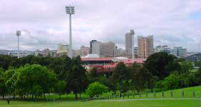
At 24 km was a brief stop at White Horse Plains with just a few houses along the road. At 36 km I made a longer stop at Dublin. A man approached and told me about his former racing and riding (on wooden rims!). He was now 83, but still looked back fondly on the riding. Dublin had a roadhouse, fruit stall, hotel and few houses. South of Dublin were several protest displays to a local waste dump. One had man on horseback and compared John Olsen to Ned Kelley (John Olsen was premier of SA until two weeks ago when he resigned in a political scandal. Ned Kelley was an infamous bush ranger who killed several and then escaped into the outback). At 50 km was Two Wells. I went onto backroads here for 13 km. Two Wells had nice main street with shops. South of Two Wells was Virginia. Virginia had both a Vietnamese restaurant and some farms with Vietnamese names. At 71 km I was back on the main highway. Salisbury listed population of 112,000 so it was getting busier. Crossed over the railroad tracks and road became three lanes. Rode the last kms into the heart of Adelaide. Enough signs to make me think it was a cycle friendly city. The inner city is completely ringed by parks. There are large pedestrian malls, e.g. Rundle Mall and other tall buildings appropriate to capital city of a million people.
October 30th; Adelaide to StrathalbynA shorter ride today after looking around Adelaide in the morning. Downtown Adelaide has many museums, monuments, a zoo and other attractions.
The museum had several displays describing WWII and immigration immediately following. After the war Australia settled more refugees than any country other than the USA. Three quarters of those from Northern Europe had their way paid and one quarter of those from Southern Europe. There were just a few displays about more recent immigration. Many apply for official authorization and are approved (language, family and occupation all seem to help here). There is a quota of 12,000 for humanitarian refugees (4000 from UN High Commission for Refugees). In recent years a larger number than that have been arriving by boat from Vietnam, Cambodia, Iraq and Afghanistan. If they arrived on Australian soil they are taken to detention centers in Port Hedland, Curtin (near Broome) and Woomera and processed for 3 year temporary visas. In the current election the largest two parties have both staked a position of being "tough" on people smuggling as way of deterring such refugees. For example, currently Australia is patrolling the seas and taking refugees it finds to Nauru, PNG and potentially other Pacific Island nations for processing (thus avoiding the 3-year temporary visa laws). I walked past a memorial to Colonel William Light who surveyed and laid out the town of Adelaide. In my opinion, he did a good job picking a site with ocean on one side, hills on the other and nice town layout with many parks. After the museum and my walks, I made my way back to the hostel and got ready to depart around 11:30am. Rundle Street mall already has Christmas decorations up! From center of town, I rode out and followed route one. At six km this became a motorway and bicycles on a separate path. The first six km were already uphill, but after that the road steepened. At ten km went onto the old road and up Eagle on the Hill. It was a slow uphill ride. Stopped for lunch at Eagle on the Hill hotel at 12 km.
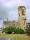
The last part of the route went through rolling hills and past small towns of Mylor, Echunga, Flaxley and Macclesfield. Most had just a country store or two. Beautiful riding as the road wound back and forth past the fields. Winds were brisk but fortunately not much headwinds. Strathalbyn is larger town with many stone buildings including nice
church. Found good place to stay in center of town. October 31st; Strathalbyn to Meningie
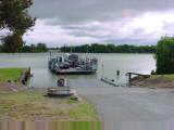
East of Strathalbyn I came past fields of hay and then vineyards for about 15 km. In center of this region was Langhorne Creek with three or four wineries. Nice tailwinds to blow me along. The road came along Lake Alexandria with marsh areas on one side and fields on the other. At 48 km I came to Wellington and the Murray River. The Murray (and Darling) drain large portions of the southeast and also provide water to 90% of South Australia's people. There was a ferry crossing the river.
Meningie is on Lake Albert, a large freshwater lake. Close to this area is Coorong National Park, a narrow lagoon along the coast. Saw several pelicans flying overhead and headed toward the lake.
|
|
Unless otherwise specified, this page © Copyright 2001-2002, Mike Vermeulen |
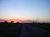
 An
easier shorter ride today. A few clouds made for a nice sunrise as I left
Mount Ebenezer. Initially land was a bit more open, but later a few more
trees. Light winds but starting to pick up through the morning from the
NE. A few gentle hills and I was fairly quickly at Erldunda roadhouse.
An
easier shorter ride today. A few clouds made for a nice sunrise as I left
Mount Ebenezer. Initially land was a bit more open, but later a few more
trees. Light winds but starting to pick up through the morning from the
NE. A few gentle hills and I was fairly quickly at Erldunda roadhouse.
 Heading
northbound again. It was already warm when I started, so except for passing
showers, today would be a hot day. Quiet at first on the Stuart Highway.
However, today in the morning I counted 25 tour buses heading southbound, 12
large size and 13 smaller size. Of these, 19 were within one half hour
window, so there must be a "leave Alice Springs at 7am, get to the rock at
noon" pattern.
Heading
northbound again. It was already warm when I started, so except for passing
showers, today would be a hot day. Quiet at first on the Stuart Highway.
However, today in the morning I counted 25 tour buses heading southbound, 12
large size and 13 smaller size. Of these, 19 were within one half hour
window, so there must be a "leave Alice Springs at 7am, get to the rock at
noon" pattern.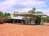
 At
103 km was a memorial written in Japanese and then over the Hugh River and into
Stuarts Well.
At
103 km was a memorial written in Japanese and then over the Hugh River and into
Stuarts Well.
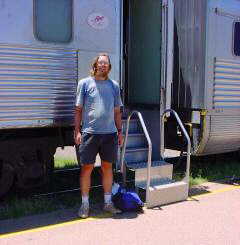
 Made
it to Alice Springs today. Since 1929 this has been "end of the line"
for the railroad. It will also be my temporary stopping point before taking the
train southbound on Friday and resuming the ride along the coasts.
Made
it to Alice Springs today. Since 1929 this has been "end of the line"
for the railroad. It will also be my temporary stopping point before taking the
train southbound on Friday and resuming the ride along the coasts.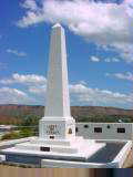
 At
60 km I start to see numerous billboards for various Alice Springs
businesses. At 69 km is a large prison (no trespassing) followed by an
industrial area. At 81 km is the airport.
At
60 km I start to see numerous billboards for various Alice Springs
businesses. At 69 km is a large prison (no trespassing) followed by an
industrial area. At 81 km is the airport.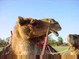
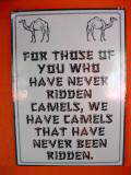 "Take
a camel to dinner", so read signs from Frontier Camel Farm. This
tourist attraction involves an hour camel ride followed by a nice dinner.
This morning I did the equivalent, aptly named, "take a camel to
breakfast". We started with a one hour ride and finished with nice
breakfast. It was a nice ride. Camels seem to pitch back and forth a
bit as they walk, more so than side to side. They also make a whole
sequence of interesting noises, belching, yawning and blowing particularly when
they're guided to do anything (e.g. stop, get up or down). The Frontier
Camel farm has about 50 camels. Rather than raise them from young, they
catch wild camels and domesticate them. Camels are put in strings tied by
the nose to next camel in line. Our tourist string had eight camels but
former drivers would have strings up to 70 (imagine having to load and unload
such a string each morning and get them started). These camels are
single-humped dromedary camels. Double humped camels are found in cooler
deserts and thus not Australia. Wild camels seem to be thriving with a
lack of predators and their adaptation to eating many different types of plants.
"Take
a camel to dinner", so read signs from Frontier Camel Farm. This
tourist attraction involves an hour camel ride followed by a nice dinner.
This morning I did the equivalent, aptly named, "take a camel to
breakfast". We started with a one hour ride and finished with nice
breakfast. It was a nice ride. Camels seem to pitch back and forth a
bit as they walk, more so than side to side. They also make a whole
sequence of interesting noises, belching, yawning and blowing particularly when
they're guided to do anything (e.g. stop, get up or down). The Frontier
Camel farm has about 50 camels. Rather than raise them from young, they
catch wild camels and domesticate them. Camels are put in strings tied by
the nose to next camel in line. Our tourist string had eight camels but
former drivers would have strings up to 70 (imagine having to load and unload
such a string each morning and get them started). These camels are
single-humped dromedary camels. Double humped camels are found in cooler
deserts and thus not Australia. Wild camels seem to be thriving with a
lack of predators and their adaptation to eating many different types of plants.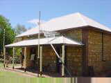
 Charles
Todd was Postmaster General of South Australia and he was charged with
organizing the building of the telegraph line in 1870. It took 23 months
and 36,000 poles to complete the initial task, quite remarkable given the
terrain and that they started with survey notes from Stuarts expedition just
seven years before. The line used galvanized wire which required the
signal to be refreshed/relayed every 300 km or so. They had a huge battery
building with ~80 simple 1.5V batteries in series. Alice Springs was one
of 12 telegraph stations along the line. In addition to 24x7 operation to
relay telegraph messages, each station also had linemen to clear brush and fix
breaks in the line (the tourist guides didn't know about either the reliability
of the line or cost of sending a message).
Charles
Todd was Postmaster General of South Australia and he was charged with
organizing the building of the telegraph line in 1870. It took 23 months
and 36,000 poles to complete the initial task, quite remarkable given the
terrain and that they started with survey notes from Stuarts expedition just
seven years before. The line used galvanized wire which required the
signal to be refreshed/relayed every 300 km or so. They had a huge battery
building with ~80 simple 1.5V batteries in series. Alice Springs was one
of 12 telegraph stations along the line. In addition to 24x7 operation to
relay telegraph messages, each station also had linemen to clear brush and fix
breaks in the line (the tourist guides didn't know about either the reliability
of the line or cost of sending a message).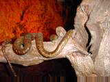
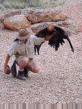 For
the afternoon I went out the Alice Springs Desert Park about 7 km out of
town. This was well done with displays of different desert environments as
well as enclosures for various birds and wildlife. Highlights included a nocturnal
house where one could see bilbies, rock wallabies, snakes, lizards and other
creatures very active in the dim light. Also went on a few guided walks
and saw an interesting demonstration with birds of prey. After having
ridden two weeks through desert country it was nice to have a formal description
and names put with plants and animals.
For
the afternoon I went out the Alice Springs Desert Park about 7 km out of
town. This was well done with displays of different desert environments as
well as enclosures for various birds and wildlife. Highlights included a nocturnal
house where one could see bilbies, rock wallabies, snakes, lizards and other
creatures very active in the dim light. Also went on a few guided walks
and saw an interesting demonstration with birds of prey. After having
ridden two weeks through desert country it was nice to have a formal description
and names put with plants and animals.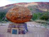
 Today
a tour of west MacDonnell Ranges with small local company, Emu Run. The
MacDonnell Range stretches 200 km to west of Alice Springs and 100 km to the
east. The row of escarpments look like a long row of caterpillars which is
also the aboriginal description. Cutting across the range are deep chasms
and also some nice waterholes. Much of the area is national park. We
spent the day stopped at multiple points along the way to 130 km west and then
back.
Today
a tour of west MacDonnell Ranges with small local company, Emu Run. The
MacDonnell Range stretches 200 km to west of Alice Springs and 100 km to the
east. The row of escarpments look like a long row of caterpillars which is
also the aboriginal description. Cutting across the range are deep chasms
and also some nice waterholes. Much of the area is national park. We
spent the day stopped at multiple points along the way to 130 km west and then
back.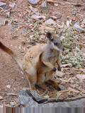
 Our
next stop was Standley Chasm. The chasm had been formed when softer
dolerite was forced into a fault in harder quartzite layers. The dolerite
was then eroded away. We had a bit longer walk here through the
chasm. Rock wallabies here were used to being fed. One had a small
joey that would poke his head out.
Our
next stop was Standley Chasm. The chasm had been formed when softer
dolerite was forced into a fault in harder quartzite layers. The dolerite
was then eroded away. We had a bit longer walk here through the
chasm. Rock wallabies here were used to being fed. One had a small
joey that would poke his head out.
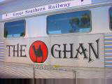
 This
train goes from Alice Springs to Sydney in just under 48 hours. Port
Augusta is 15.5 hours away, twice as fast as the pre-1980 Ghan route. The
front cars are sleepers. After the sleepers is a dining car followed by a
lounge. After the lounge car were two coach cars and then a smoking
lounge. Behind the lounge were baggage cars. I had a seat in the
first coach car. The coach cars were almost completely full, though I was
fortunate to be able to stretch into adjacent empty seat.
This
train goes from Alice Springs to Sydney in just under 48 hours. Port
Augusta is 15.5 hours away, twice as fast as the pre-1980 Ghan route. The
front cars are sleepers. After the sleepers is a dining car followed by a
lounge. After the lounge car were two coach cars and then a smoking
lounge. Behind the lounge were baggage cars. I had a seat in the
first coach car. The coach cars were almost completely full, though I was
fortunate to be able to stretch into adjacent empty seat.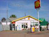
 Back
to riding the edges of Australia after a three week side trip to the
middle. Rail coach seats are better for sleeping than airline seats,
though not as good as a bed. The train changed crews at Tarcoola and also
stopped for a bit. They may have joined with cars from a Perth train,
though I'm not certain. At 4 am we were awakened and told to anticipate
Port Augusta in 20 minutes. Shortly thereafter lights of the town came
into view. The train was too long for the station, so it took a bit to get
my bicycle since they first unloaded the front and then pulled the train
forward.
Back
to riding the edges of Australia after a three week side trip to the
middle. Rail coach seats are better for sleeping than airline seats,
though not as good as a bed. The train changed crews at Tarcoola and also
stopped for a bit. They may have joined with cars from a Perth train,
though I'm not certain. At 4 am we were awakened and told to anticipate
Port Augusta in 20 minutes. Shortly thereafter lights of the town came
into view. The train was too long for the station, so it took a bit to get
my bicycle since they first unloaded the front and then pulled the train
forward.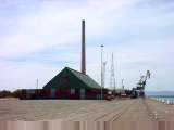
 At
21 km was turnoff to Broken Hill and "back route" to Sydney. At
30 km I started to see first wheat fields. They seemed quite a bit further
along than wheat I had last seen three weeks ago. At 44 km was Mambray
Creek with a Shell Roadhouse and stop for a snack. A little past was
Baroota with a few old buildings and a monument to a church that no longer
existed. At 69 km was a turnoff to Port Germain which boasts the
"longest wooden jetty in Australia". Finally at 85 km I came to
turnoff to Port Pirie and then another 6 km into town.
At
21 km was turnoff to Broken Hill and "back route" to Sydney. At
30 km I started to see first wheat fields. They seemed quite a bit further
along than wheat I had last seen three weeks ago. At 44 km was Mambray
Creek with a Shell Roadhouse and stop for a snack. A little past was
Baroota with a few old buildings and a monument to a church that no longer
existed. At 69 km was a turnoff to Port Germain which boasts the
"longest wooden jetty in Australia". Finally at 85 km I came to
turnoff to Port Pirie and then another 6 km into town.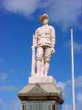
 Today
a beautiful ride on smaller country roads and passing through several small
towns. Last night was a shift to summer time. Not a big change for
me since I time things relative to sunrise. Sunrise is about 30 minutes
earlier here than in Alice Springs.
Today
a beautiful ride on smaller country roads and passing through several small
towns. Last night was a shift to summer time. Not a big change for
me since I time things relative to sunrise. Sunrise is about 30 minutes
earlier here than in Alice Springs.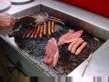
 Port
Broughton would have been a nice place to stay, but it was still early so
continued further. Some gentle climbs and hills heading south. More
wheat, hay, barley, alfalfa and other crops. At 88 km I came to Bute,
population 300. The hotel in town had a lunch special. For $6 I was
given two large steaks, some sausages and directions to the barbie out
back. Lunch also included vegies and salad. For equivalent of three
US dollars, had one of the most filling meals in Australia (turned out to be
both lunch and dinner). There was a bus out front with people from a club
in Adelaide on a "mystery tour". They had paid $10 this morning
for an unknown destination that turned out to include lunch in Bute.
Another cute fun town.
Port
Broughton would have been a nice place to stay, but it was still early so
continued further. Some gentle climbs and hills heading south. More
wheat, hay, barley, alfalfa and other crops. At 88 km I came to Bute,
population 300. The hotel in town had a lunch special. For $6 I was
given two large steaks, some sausages and directions to the barbie out
back. Lunch also included vegies and salad. For equivalent of three
US dollars, had one of the most filling meals in Australia (turned out to be
both lunch and dinner). There was a bus out front with people from a club
in Adelaide on a "mystery tour". They had paid $10 this morning
for an unknown destination that turned out to include lunch in Bute.
Another cute fun town.
 Today increasingly busy as I cycled to the city of Adelaide. Two kms
from Port Wakefield the road changed to a divided highway with two lanes each
way. Shoulders were less than 30 cm and the white line was marked with
obnoxious red reflectors that were bumps if one rode over them. Traffic
generally gave me plenty of room, though riding took some extra concentration.
Today increasingly busy as I cycled to the city of Adelaide. Two kms
from Port Wakefield the road changed to a divided highway with two lanes each
way. Shoulders were less than 30 cm and the white line was marked with
obnoxious red reflectors that were bumps if one rode over them. Traffic
generally gave me plenty of room, though riding took some extra concentration.
 Stayed at Backpack Oz hostel. Tom Twelfthtree had sent me email about
this hostel run by his family, so I stayed there. Good location and nice
hostel. After settling in, I found the Olympus repair store and walked
over with broken digital camera. They will send it to Melbourne and I can
pick it up in Melbourne at end of November. Hopefully can be fixed.
Otherwise walked around downtown. The hostel is recruiting players for the
volleyball team and preparing decorations for a Halloween party.
Stayed at Backpack Oz hostel. Tom Twelfthtree had sent me email about
this hostel run by his family, so I stayed there. Good location and nice
hostel. After settling in, I found the Olympus repair store and walked
over with broken digital camera. They will send it to Melbourne and I can
pick it up in Melbourne at end of November. Hopefully can be fixed.
Otherwise walked around downtown. The hostel is recruiting players for the
volleyball team and preparing decorations for a Halloween party.
 I was most intrigued by the Migration Museum, to capture South Australian
immigration history. It had displays describing several different phases
of immigration. Early migrants in the 1840s included those from Great
Britain, Germany and Poland followed by others including "Afghans",
Chinese, Italians, Lebanese and Scandinavians. Unlike other states in
Australia, South Australia was established as an idealistic idea of a state of
free settlers (other states were first established using convicts from Great
Britain...causing Adelaide persons still occasionally referring to rest of
Australia as "the convict states").
I was most intrigued by the Migration Museum, to capture South Australian
immigration history. It had displays describing several different phases
of immigration. Early migrants in the 1840s included those from Great
Britain, Germany and Poland followed by others including "Afghans",
Chinese, Italians, Lebanese and Scandinavians. Unlike other states in
Australia, South Australia was established as an idealistic idea of a state of
free settlers (other states were first established using convicts from Great
Britain...causing Adelaide persons still occasionally referring to rest of
Australia as "the convict states").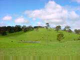
 After lunch more uphill in Crafters and Stirling. From here I tried to
find the route to Strathalbyn. I rode along Old Mount Barker Road but
didn't see any signs for Strathalbyn. Eventually the road stopped with
signs "no through route." Made my way back and asked, eventually
finding the route with ~5 km extra distance.
After lunch more uphill in Crafters and Stirling. From here I tried to
find the route to Strathalbyn. I rode along Old Mount Barker Road but
didn't see any signs for Strathalbyn. Eventually the road stopped with
signs "no through route." Made my way back and asked, eventually
finding the route with ~5 km extra distance.
 Todays
ride had an easy half and a difficult half. Gusty winds from the SW across
more open terrain. Yesterday I had finished crossing the Adelaide Hills so
just a few bumps and then mostly flat.
Todays
ride had an easy half and a difficult half. Gusty winds from the SW across
more open terrain. Yesterday I had finished crossing the Adelaide Hills so
just a few bumps and then mostly flat.
 Two
kms past the Murray River I was back to route one again. Here I turned
southwards and more into the wind causing my speed to drop 60%. From here
a slow ride with a few hills at 73 km and Pink Lake at 81 km. Ready for a
break when I reached Meningie. News reports that Adelaide has had the
windiest October since 1971.
Two
kms past the Murray River I was back to route one again. Here I turned
southwards and more into the wind causing my speed to drop 60%. From here
a slow ride with a few hills at 73 km and Pink Lake at 81 km. Ready for a
break when I reached Meningie. News reports that Adelaide has had the
windiest October since 1971.