

November 1st-10th, 2001
Map 35
November 1st; Meningie to Kingston
 Today
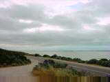
a pretty ride along Coorong National Park. The Coorong is a long narrow
park. High dunes are on ocean side with a shallow lagoon and marsh
behind. Many birds and other animals on the wetlands. Saw signs for
mullet for sale and for fishing. Saw pelicans flying, a pheasant and other
smaller birds.
Today
a pretty ride along Coorong National Park. The Coorong is a long narrow
park. High dunes are on ocean side with a shallow lagoon and marsh
behind. Many birds and other animals on the wetlands. Saw signs for
mullet for sale and for fishing. Saw pelicans flying, a pheasant and other
smaller birds.
Adelaide news reported it was the windiest October since 1971. The
first of November started with calm winds, a nice change from yesterday. A
few gentle hills and then the road came along a lagoon. I could smell the
mud. Quiet riding for 51 km where I stopped at Policemans Point for
brekky.
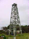
At 61 km was Salt Creek and a brief stop. There was an oil derrick
replica for when they once searched for oil (before realizing the ooze came from
algae and not oil seeps from below). After this point the lagoon ended and
there were thick trees on both sides. An occasional gentle hill, but
mostly flat. Around 120 km came to end of the Coorong. Less trees,
more open terrain and also more wind. Since Port Augusta there haven't
been triple road trains. However a normal cattle semitrailer sends a
considerable gust with the crosswinds. Still not much in way of shoulders
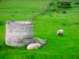
but most traffic gives room. This last part was farming region with sheep
and cattle. At 137 km a memorial to a police officer slain in 1881.
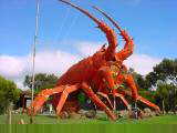
 At
145 km came to Kingston, population 1800. A giant rock lobster stood at
north end of the town. Lobster festival is in January. Several
streets with stores and small jetty. Saw a tractor museum listed but
didn't see it along the way.
At
145 km came to Kingston, population 1800. A giant rock lobster stood at
north end of the town. Lobster festival is in January. Several
streets with stores and small jetty. Saw a tractor museum listed but
didn't see it along the way.
145 km today, 21374 km cumulative.
Map 36
November 2nd; Kingston S.E. to Beachport
 Today
a nice ride through pasture lands and past several beach towns. At
Kingston the road splits into Highway One (106 km) and Highway One Alternate
(~120 km, though my route will be longer with side trips). I took the
coastal alternate route. Stronger SW winds today though the worst of the
headwinds were sometimes blocked by trees.
Today
a nice ride through pasture lands and past several beach towns. At
Kingston the road splits into Highway One (106 km) and Highway One Alternate
(~120 km, though my route will be longer with side trips). I took the
coastal alternate route. Stronger SW winds today though the worst of the
headwinds were sometimes blocked by trees.
South of Kingston was the Mount Benson wine region. Saw only one winery
though. Came through Noolook Forest Reserve with tall trees planted in
neat rows. At 41 km was a turnoff and at 44 km was Robe.
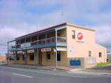
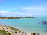
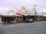
Robe is one of the early ports in the South East and still has a fishing
fleet. Robe had quite a few motels, cafes, stone buildings and quaint
shops. Seemed almost too touristy though nice place for mid-morning
snack. I dawdled a bit reading the paper as a brief shower came through.
 After
Robe the route went inland and past several inland lakes. Apparently
rivers in this area end in marshes and didn't naturally drain to the sea.
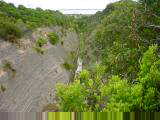
As a result a network of drainage canals have been built. At 80 km was a
rather remarkable sight, Murray McCourt's Woakwine Cutting. This was a one
km long cut through the hill to depth of 28 meters. Murray and a hired
help spent three years from 1957 to 1960 removing 276,000 cubic meters of rock
to make this drainage channel to drain a large swamp on his property.
Drainage still seems to be an ongoing issue as I noticed local papers carried
notice that the Premier will be formally opening another drainage channel
tomorrow in Millicent.
After
Robe the route went inland and past several inland lakes. Apparently
rivers in this area end in marshes and didn't naturally drain to the sea.
As a result a network of drainage canals have been built. At 80 km was a
rather remarkable sight, Murray McCourt's Woakwine Cutting. This was a one
km long cut through the hill to depth of 28 meters. Murray and a hired
help spent three years from 1957 to 1960 removing 276,000 cubic meters of rock
to make this drainage channel to drain a large swamp on his property.
Drainage still seems to be an ongoing issue as I noticed local papers carried
notice that the Premier will be formally opening another drainage channel
tomorrow in Millicent.
Along the way mostly sheep with some cattle. These beasts seem to be
skittish about bicycles again, so I've been causing small stampedes.
At 94 km I came to Beachport and had enough cycling into the wind for the
day. Beachport is a small community with large beach. Historically
it was a whaling town with small cairn marking the first whaling station.
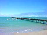
Beachport also has South Australia's second longest pier. It looks longer
than Port Broughton (SA longest wooden pier), so not certain where a longer one
is found. The tourist info also didn't know.
This coming Tuesday is the Melbourne Cup and a holiday in Victoria. As
a result all motels were already full due to the holiday weekend. Found an
out of the way place in the caravan park, though later multiple campers parked
right next door. Hope they will be quiet tonight.
94 km today, 21468 km cumulative.
November 3rd; Beachport to Nelson
 Made
it to Victoria today, sixth state/territory so far.
Made
it to Victoria today, sixth state/territory so far.
Last night my tent was next to the defacto soccer field. Fortunately
the game stopped not long after dark. Some caravaners explained that sand
dunes near Beachport are firm enough that one can drive to Robe. This
explained the abundance of motorcycles and four wheel drive vehicles I
saw. Also learned that Beachport has large percentage of millionaires due
to a lucrative lobster trade.
Calm winds but with mosquitoes when starting out. Flat terrain made for
good progress. I crossed over several man-made drainage canals
again. I also got dive bombed several times today by territorial
magpies. Typically about half a dozen close swoops where I'd hear a whoosh
and occasionally some clicks.
Millicent was at 35 km. There is supposed to be both motorcycle rally
and sheep shearing competition but town was still asleep as I came
through. Stopped at petrol station for some snacks and then continued.

 At
45 km was a large sawmill. In the following 40 km I came past many areas
with planted trees at various ages. It surprised me how quickly these
trees would grow. For example, 30 year old trees at 15 meters tall and 30
cm in diameter.
At
45 km was a large sawmill. In the following 40 km I came past many areas
with planted trees at various ages. It surprised me how quickly these
trees would grow. For example, 30 year old trees at 15 meters tall and 30
cm in diameter.
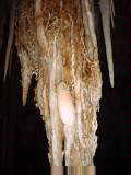
At 55 km was another stop for Tantanoola Caves. A beautiful cavern with
many delicate thin pipes, curtains and other structures. This is one of
two dolomite caves in Australia, resulting in nice brown tint.
Just past the caves, came on three cyclists raising money for charity by
riding from Melbourne to Adelaide. Their support driver was also
stopped. This was day seven of thirteen of their ride.
At 85 km came into Mount Gambier, population 22000. The town is named
after an extinct volcano that erupted 4300 years ago and is still on south side
of town. A few little hills to climb through the city. Had a late
lunch and read the paper. Also stopped at the Lady Nelson Visitor Center
aand looked through the "discovery center". This had displays on
geology, natural history and a scale replica of the brig Lady Nelson.
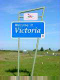
It was getting late, but decided to ride last 36 km to the border. A
few more bouncing hills as well as winds picking up from SE meant it was a bit
slower riding. I was pleased to see the Welcome to Victoria sign at 117
km. Hooray!
121 km today, 21589 km cumulative.
November 4th; Nelson to Port Fairy
 Nice
riding through rural Victoria. The time changed 30 minutes ahead yesterday
at the border. Nelson is located on the wide Glenelg River with boating
and fishing. Crossed over the river on a high bridge constructed in
1997. After leaving Nelson the road came across a sequence of small
hills. Biggest climb was 30 km out and it got flatter after that.
Landscapes had a mixture of forests (some with trees planted in neat rows),
pastures and even a vineyard. It looks like they trim lower branches from
the pine trees. The road had bits of bark on it, but didn't see any log
trucks passing today. More forests close to Nelson and more pastures close
to Portland. I could smell fresh cut hay. Some of the cut hay is
bundled with giant blue plastic. Along the way I saw kangaroos, emus,
rabbits and many birds. Fortunately the magpies were less territorial
today.
Nice
riding through rural Victoria. The time changed 30 minutes ahead yesterday
at the border. Nelson is located on the wide Glenelg River with boating
and fishing. Crossed over the river on a high bridge constructed in
1997. After leaving Nelson the road came across a sequence of small
hills. Biggest climb was 30 km out and it got flatter after that.
Landscapes had a mixture of forests (some with trees planted in neat rows),
pastures and even a vineyard. It looks like they trim lower branches from
the pine trees. The road had bits of bark on it, but didn't see any log
trucks passing today. More forests close to Nelson and more pastures close
to Portland. I could smell fresh cut hay. Some of the cut hay is
bundled with giant blue plastic. Along the way I saw kangaroos, emus,
rabbits and many birds. Fortunately the magpies were less territorial
today.
At 30 km was a lookout to the coast and site of a shipwreck below. This
area is known as Discovery Bay and the Shipwreck Coast. Many boats had
wrecked here between late 1800s and early 1900s.
As I got closer to Portland at 68 km, signs were marked for the 3 Bays
Marathon (Discovery Bay, Bridgewater Bay and Portland Bay). It was close
to the finish line and runners were starting to arrive. Portland was
settled in 1834 and is oldest town in Victoria. Today it has a large
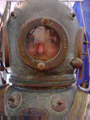
harbor for loading local cargos like woodchips or sheep. In Portland I
went through the Maritime Discovery Museum. The museum had exhibits about
shipwrecks, lifesaving, marine creatures and diving...though was about average
as such museums go. After the museum a leisurely lunch and reading the
Sunday paper. As I've ridden along I've also been shifting papers: Courier
Mail (Brisbane), NT Times (Darwin), Western Australian (Perth), Advertiser
(Adelaide), NT Times, Advertiser and now the Sun (Melbourne). Interesting
to see local concerns and issues.
 After
lunch decided I'd get a bit more distance. Tourist bureau told me it would
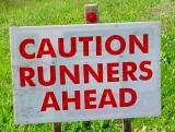
be flatter and they were correct. I came past the marathon route with
slower walkers/runners now finishing. Definite contrast with runners from
three hours before. I gave a thumbs up and smile of encouragement.
After
lunch decided I'd get a bit more distance. Tourist bureau told me it would
be flatter and they were correct. I came past the marathon route with
slower walkers/runners now finishing. Definite contrast with runners from
three hours before. I gave a thumbs up and smile of encouragement.
Mostly small farms along the way with a few small settlements: Allestree,
Narrawong, Tyredarra, Codrington and Yambuk. Codrington had 14 large wind
turbines and place for tours (www.myportfairy.com/windfarmtours).
I skipped the tour but did speak briefly with Tim. He let me know of other
cycle tourists on tandem just ahead. I also saw a couple on tandem heading
west though we didn't stop. Codrington was also supposed to have a
heritage festival. However as I passed saw only three old tractors and
four dollars entry, so continued past.
From the wind farm, a last 27 km and I was at Port Fairy. In the 1820s,
Captain Wishart sailed his ship, "Fairy" into the Moyne River to
escape a storm. Hence the name. Port Fairy has two streets of shops,
multiple motels and cafes. Lots of tourists out walking the streets.
139 km today, 21728 km cumulative.
November 5th; Port Fairy to Peterborough
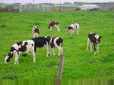
 An
overcast and rainy day today. Left Port Fairy and cycled through mostly
flat farmlands with black and white dairy cows. One hill to climb at tower
hill, but otherwise quick travel for 28 km to Warrnambool, population
26000. Wider shoulders and fast traffic along this road. Light
sprinkles along the way and then a brief shower as I had brekky.
Warrnambool had a monument to an annual bicycle ride from Melbourne to
Warrnambool. Good collection of bicycle signs and lanes, though also
directed bikes onto bumpy sidewalks for a while.
An
overcast and rainy day today. Left Port Fairy and cycled through mostly
flat farmlands with black and white dairy cows. One hill to climb at tower
hill, but otherwise quick travel for 28 km to Warrnambool, population
26000. Wider shoulders and fast traffic along this road. Light
sprinkles along the way and then a brief shower as I had brekky.
Warrnambool had a monument to an annual bicycle ride from Melbourne to
Warrnambool. Good collection of bicycle signs and lanes, though also
directed bikes onto bumpy sidewalks for a while.
Road heading out from Warrnambool was busy, but after 12 km was a turnoff to
the Great Ocean Road. I've been seeing Great Ocean Road signs since the
SA/Victoria border, but believe this is the more traditional start of this
scenic route.
 Within
a few km of the turnoff was a giant cheese and butter factory and a shop named
"Cheeseworld". One could sample the cheese, purchase cheese and
other products. There was a small free historical museum with farm
implements, butter churns, cheese presses, an old generator and other
items. It seemed to be missing many particulars about their operations,
but still a nice stop.
Within
a few km of the turnoff was a giant cheese and butter factory and a shop named
"Cheeseworld". One could sample the cheese, purchase cheese and
other products. There was a small free historical museum with farm
implements, butter churns, cheese presses, an old generator and other
items. It seemed to be missing many particulars about their operations,
but still a nice stop.
After Cheeseworld, back to riding through farmlands. These cows aren't
as skittish as further out. Stopped briefly at a settlement Nullawarre and
then followed the road to the coast. Stopped here at overlook for the Bay
of Islands. In the bay is a collection of short rock stacks. White
specks of birds were on some islands. It was overcast on verge of drizzle,
but still a nice view.
As I rode the last 5 km to Peterborough, got some more drizzle. It was
still early, but I decided to stop for the day in hopes of getting some clearer
weather tomorrow morning for the scenic lookouts to be found just ahead.
81 km today, 21809 km cumulative.
November 6th; Peterborough to Lavers Hill
 Wind,
rain, hills and beautiful scenery conspired today to make for shorter
distance. Last night a front came through with heavy rain. This
morning had strong south winds and light drizzle. Crossed over Curdie's
Inlet and then through gentle hills along the coast.
Wind,
rain, hills and beautiful scenery conspired today to make for shorter
distance. Last night a front came through with heavy rain. This
morning had strong south winds and light drizzle. Crossed over Curdie's
Inlet and then through gentle hills along the coast.
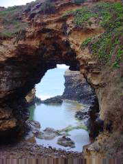
The first 30 km were through Port Campbell National Park with dramatic
cliffs, arches, islands, rock stacks and crashing waves. Geologically
speaking this area is very recent, 18,000 years since the seas dropped and these
limestone cliffs started eroding back. At 6 km I stopped at the Grotto,
the first arch. Small steps led down to the base with nice views of seas
behind.
 At
7 km was London Bridge. London Bridge was falling down on January 15th,
1990 when a span connecting it to the main shore collapsed, stranding two
tourists.
At
7 km was London Bridge. London Bridge was falling down on January 15th,
1990 when a span connecting it to the main shore collapsed, stranding two
tourists.
Shortly past London Bridge was another arch, named "The
Arch". Just past that was Port Campbell at 13 km. Had brekky at
Port Campbell while another drizzle shower came past letting me dawdle a bit.
At 20 km was another turnoff to Loch Ard Gorge. This is site where the
sailing ship, "Loch Ard" wrecked in 1878 with 36 crew and 18
passengers on board. Only two survived and only four bodies washed
ashore. I took the short walking trails to view location of the little cemetery
where others were buried. There was another arch, an area with muttonbirds
and other places to see. I had fun going to different tails and lookouts.
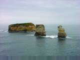
 At
24 km was my next stop at the Twelve Apostles at a large parking area and
exhibition pavilion and paved trail to cliffs edge. These apostles are
large rock stacks in the ocean. Depending on how you count, there are
either seven or nine visible. Sun was coming out and it was nice to see
the apostles in a row.
At
24 km was my next stop at the Twelve Apostles at a large parking area and
exhibition pavilion and paved trail to cliffs edge. These apostles are
large rock stacks in the ocean. Depending on how you count, there are
either seven or nine visible. Sun was coming out and it was nice to see
the apostles in a row.
Another kilometer down the road was Gibson Steps. This was another
large rock stack. I walked down to Gibson Beach, watching the waves
crashing onto the beach beautiful scenery behind.
A little east of Gibson Steps the road headed inland and along some gentle
hills. I climbed a little hill up to Princeton to lunch at 34 kms.
Princeton had small restaurant/pub and also a post office and store.
From Princeton the route went inland and uphill through the forest. It
was slow going in my low gears. The road climbed up on a ridge before
descending to the Gellibrand River and then slowly climbing again. Some
parts were steep enough to have me get into granny gears.
 At
3:10 pm in first Tuesday in November is the "race that stops the
nation", the Melbourne Cup. I came to the Lavers Hill Roadhouse at
3:15pm to find the roadhouse closed with about 25 people in the bar. The
race was already over and a horse named Ethereal won (I'm just happy one named
"Rain Gauge" didn't). Apparently over 100 million dollars is bet
nationwide ($53 million in Victoria last year) and about 92,000 people came to
the track at Flemington (120,000 last year). In addition to ten horse
races, it is also a major fashion display with hats seeming to be prominent
accessory (though this year umbrellas seem necessary as well). I did meet
two couples earlier today from Melbourne who were happy to escape all the
Melbourne Cup hype and drive the Great Ocean Road instead.
At
3:10 pm in first Tuesday in November is the "race that stops the
nation", the Melbourne Cup. I came to the Lavers Hill Roadhouse at
3:15pm to find the roadhouse closed with about 25 people in the bar. The
race was already over and a horse named Ethereal won (I'm just happy one named
"Rain Gauge" didn't). Apparently over 100 million dollars is bet
nationwide ($53 million in Victoria last year) and about 92,000 people came to
the track at Flemington (120,000 last year). In addition to ten horse
races, it is also a major fashion display with hats seeming to be prominent
accessory (though this year umbrellas seem necessary as well). I did meet
two couples earlier today from Melbourne who were happy to escape all the
Melbourne Cup hype and drive the Great Ocean Road instead.
I had only ridden 63 km today, but nice to be at top of the hill and get a
rest. Still beautiful views from up here down past forests to the sea.
63 km today, 21872 km cumulative.
Map 37
November 7th; Lavers Hill to Lorne
 A
pretty ride first to the coast and then along the coast. Weather forecast
called for showers early and then clearing but it did the opposite with mostly
clear skies starting out.
A
pretty ride first to the coast and then along the coast. Weather forecast
called for showers early and then clearing but it did the opposite with mostly
clear skies starting out.
First 15 km were mostly downhill with just two slight uphill climbs.
This is country where the sheep and cows would do well to have shorter legs on
one side. Beautiful green pastures on these hills. At 15 km was
Glenaire a brief view of the coast and a turn back inland and along a
valley. Mostly flat for a while before climbing again near Hordem Vale at
24 km. Several signs for B&Bs or self-contained cabins, one gets the
impression homeowners in this area do this for supplementary income. It
definitely has feel of a vacation area.
From Hordem Vale junction a slow climb up and over the hills again. I
met two New Zealand cyclists riding from Geelong to Warrnambool, the Great Ocean
Road. We traded info briefly before I descended into Apollo Bay at 48 km.
Apollo Bay is a small resort town with shops and many accommodation
choices. I had brekky at a cafe. The slow service let me read the
entire paper and check Pocketmail. From Apollo Bay the road went along the
coast, mostly flat except where it would climb along the hills. Hills were
steep off to the ocean. However, unlike yesterday no sheer 20 meter cliffs
at the edge. Nice views as I rode along with an occasional small
settlement and more signs for an occasional B&B. Made reasonable
progress to reach Lorne by early afternoon. Many more tour buses out
today.
 The
drizzle started about 5 km prior to Lorne and harder rain gave me excuse to
wander past shops, get a bite to eat. Folks were out collecting for
Greenpeace and stopping people on the street. While the worst of the rain
subsided, there was still drizzle and grey skies on the horizon. Decided
to make it an early day.
The
drizzle started about 5 km prior to Lorne and harder rain gave me excuse to
wander past shops, get a bite to eat. Folks were out collecting for
Greenpeace and stopping people on the street. While the worst of the rain
subsided, there was still drizzle and grey skies on the horizon. Decided
to make it an early day.
I got a Melbourne map and checked up on the ferry schedules to
Tasmania. Looks like I have ~140 km and two days until the next
ferry. Also I was surprised to discover my back tire had bare patches
again. Not going to replace it yet, but have barely 2500 km since it was
new in Port Augusta.
93 km today, 21965 km cumulative.
November 8th; Lorne to Werribee
 The
numbers for today are 30 and 8. The Australian newspaper has a weather map
with 55 cities listed. When I came to Geelong, this was the 30th weather
map city I have visited. Tomorrow Melbourne should be #31. (Back in
the US, I'll have to compare how I've done against the USA Today weather
map).
The
numbers for today are 30 and 8. The Australian newspaper has a weather map
with 55 cities listed. When I came to Geelong, this was the 30th weather
map city I have visited. Tomorrow Melbourne should be #31. (Back in
the US, I'll have to compare how I've done against the USA Today weather
map).
 Beautiful
almost clear skies with fresh east winds this morning. Nice ride along the
coast with occasional climb over a hill. Just after "Big Hill
Creek", the road climbed to 95m at Cinema Point. Shortly thereafter
Fairhaven had some luxurious looking houses perched precariously on the
hillside.
Beautiful
almost clear skies with fresh east winds this morning. Nice ride along the
coast with occasional climb over a hill. Just after "Big Hill
Creek", the road climbed to 95m at Cinema Point. Shortly thereafter
Fairhaven had some luxurious looking houses perched precariously on the
hillside.
At 18 km I came to Aireys Inlet for a break. I phoned TT Lines to book
a ferry trip on the Spirit of Tasmania for tomorrow. At 28 km was small
town of Anglesea with a store to get some brekky.
Road shoulders were wide as the road climbed a hill away from the coast from
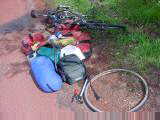
Anglesea. I was thinking how much glass was on the road when I heard a
hissing from my back tire. While glass might have contributed, primary
cause for the flat was because I'd worn through the tire. This means I've
now worn through eight tires, two in front and six in back. I unloaded
things and then slowly got back tire #7 on before loading again.
 At
48 km was Torquay, the largest town I've been through since Warrnambool (and
perhaps larger than Warrnambool). It is also home to Rip Curl surfboard
manufacturer and the Australian Surfing Museum. A fun little museum.
While stopped at the info center I met with Keith from the UK who was cycling
Sydney to Adelaide. A short bit later, Terry from Brisbane cycled
up. Terry was riding from Brisbane to Adelaide. I had lunch at the
McDonalds where I met two cyclists from New Zealand who were riding Adelaide to
Melbourne. Wow!
At
48 km was Torquay, the largest town I've been through since Warrnambool (and
perhaps larger than Warrnambool). It is also home to Rip Curl surfboard
manufacturer and the Australian Surfing Museum. A fun little museum.
While stopped at the info center I met with Keith from the UK who was cycling
Sydney to Adelaide. A short bit later, Terry from Brisbane cycled
up. Terry was riding from Brisbane to Adelaide. I had lunch at the
McDonalds where I met two cyclists from New Zealand who were riding Adelaide to
Melbourne. Wow!
Map 37
From Torquay the #1 recommended cycle route to Melbourne is to cross from
Queenstown to the Mornington Peninsula and ride the east side to
Melbourne. The #2 recommendation is to take the train from Geelong to
Melbourne. Neither of these suited me, so I asked further. Problem
is that much of the direct route is the M1 Motorway. I asked and was told
bicycles were allowed on the Motorway even if it is unpleasant.
So I set off for Geelong another 21 km further. Surprisingly busy city
with a fair amount of roadwork going on. I passed two bicycle shops and at
the second one, The Bicycle Factory, they had a good replacement tire. The
owner of The Bicycle Factory also had more details about the route into
Melbourne. Roadworks were happening on the motorway, so there was an
extensive detour for bicycles.
I rode on a busy road through Geelong. Occasionally there were signs of
service roads in parallel with a "cyclists ride on service road"
sign. While it got out of traffic, it was also obnoxious since these side
roads sometimes ended with a very awkward search for how to continue again.
At North Geelong I finally left the main highway and took smaller roads via
Lara and Little River. A brief stretch of 7 km back on side of M1
Motorway. Eventually ended up in Werribee. Had a bit of a seach but
found a motel. Long day overall.
114 km today, 22079 km cumulative.
November 9th; Werribee to Melbourne
 A
short ride today ending on the Spirit of Tasmania. A few showers early in
the morning, but then a clear sunny day. I took the back roads into the
city. Navigation wasn't too hard since the skyscrapers were visible.
The first 10 km were agricultural passing by the Open Range Zoo and a RAAF
base. On outskirts of Laverton were new homes. Stopped there for
brekky before continuing via Altona and Williamstown and passing refineries,
sewage treatment and industrial areas.
A
short ride today ending on the Spirit of Tasmania. A few showers early in
the morning, but then a clear sunny day. I took the back roads into the
city. Navigation wasn't too hard since the skyscrapers were visible.
The first 10 km were agricultural passing by the Open Range Zoo and a RAAF
base. On outskirts of Laverton were new homes. Stopped there for
brekky before continuing via Altona and Williamstown and passing refineries,
sewage treatment and industrial areas.
At 28 km I rode into heart of Williamstown since I'd heard of a ferry.
However, it was more of a tourist ferry going right downtown. So back
along the shore to Footscray in combination of bike paths and streets.
Melbourne has quite a few cycle lane markings but unfortunately also a lot of
glass on the road. From Footscray past the industrial docklands district
and then downtown at 40 km. Hooray, made it to Melbourne!
I walked my bike through parts of the Central Business District going via
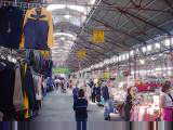
Victoria Markets, Swanston Street, Bourke Mall and to Federation Square.
Trolly lines go through middle of some of these streets making them feel a bit
busy as a pedestrian. Stopped off at the post office and looked at book
stores. Nice downtown though think I prefer Adelaide and Perth as a
pedestrian. Environment protestors had hung a banner on a spire by the
National Gallery.
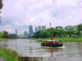
 I
crossed over the Yarra River and then rode along the south bank past the botanic
gardens. Briefly rode north to Richmond to check on my camera (not ready
yet) and then back to center of town. From here I rode around Albert Park
to the bay and then back to Station Pier.
I
crossed over the Yarra River and then rode along the south bank past the botanic
gardens. Briefly rode north to Richmond to check on my camera (not ready
yet) and then back to center of town. From here I rode around Albert Park
to the bay and then back to Station Pier.
Only 2:30 pm but the Spirit of Tasmania was berthed and starting to
load. I was able to board my bike and tie it off on the car deck.
From here I found my cabin (four berths, shared accommodation in middle of the
ship).
65 km today, 22144 km cumulative.
Map 40
November 10th; Melbourne to Devonport (ferry) to
Burnie (bicycle)
 Nice
to make it back to Tasmania. My previous trip was two years ago while
investigating this round Australia trip and is described here.
Tasmania lies across the Bass Straight about 240 km south of rest of
Australia. The island is 83,000 km2 so only about as big as ten
of the largest cattle/sheep stations I've passed or twenty average size
stations. However, it is hillier with the saying being if you ironed it
out, Tasmania would be half the size of rest of Australia! The west is
wetter and hillier than the east of Tasmania. Last time I went through the
east coast and middle, so I plan on riding through the hills in the west this
time (forecasts called for bits of hail and snow on top peaks).
Nice
to make it back to Tasmania. My previous trip was two years ago while
investigating this round Australia trip and is described here.
Tasmania lies across the Bass Straight about 240 km south of rest of
Australia. The island is 83,000 km2 so only about as big as ten
of the largest cattle/sheep stations I've passed or twenty average size
stations. However, it is hillier with the saying being if you ironed it
out, Tasmania would be half the size of rest of Australia! The west is
wetter and hillier than the east of Tasmania. Last time I went through the
east coast and middle, so I plan on riding through the hills in the west this
time (forecasts called for bits of hail and snow on top peaks).
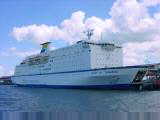
Travel on Spirit of Tasmania was nice. This huge ferry is 6th largest
in the world. It has space for 1323 passengers, 315 cars and 40
semi-trailers and weighs as much as 90 747s. If all cars carried during a
year were lined end to end, they would stretch from Melbourne to Sydney.
There are six passenger decks with cabins and three vehicle decks. There
were 1050 passengers on board including five traveling by bicycle. All the
bikes had fenders. I was on deck J, just at the waterline and below the
vehicle decks, in a 4 person shared cabin. My roommate was from Tasmania,
but now lived in Melbourne for medical reasons (waiting for a liver transplant I
believe). There are several restaurants and lounges, a photographer, video
games, poker machines, movie theater, tourist info center and shops. I saw
diagrams listing a swimming pool in bowels of the ship, but wasn't able to find
it. The photographer took the classic boarding photos for later
sale. The fare included buffet dinner and breakfast. The boat goes
three times a week and takes 14 hours. I slept quite well with only deep
hum of engines and occasional splashing of water at waterline. My roommate
won about $1000 in the casino and came in late. I got the maps out and
starting looking a bit more at Tasmania destinations. Had to wait 80
minutes after arrival before I could finally leave with my bike.
On leaving the ferry and passing through quarantine check, I followed signs
to major two lane each way highway from Devonport. The road went over a
few smaller practice hills via Don and then along the shore. At 22 km was
small town of Ulverstone and a lunch stop. Ulverstone had a nice center
with small shops. They seem to be more open here on Saturday
afternoon. I'm told it is because of restrictions on Sunday opening.
From Ulverstone there is a scenic route right along the coast. Nice
rocky islands, a narrow gauge railway and one point where one could watch fairy
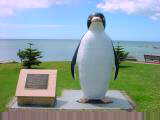
penguins come ashore. At 34 km was the town named Penguin. The
penguin motif was spread throughout the town in shop names, statues and signs.
Today is election day and polls are open from 8 am to 6 pm. Each three
years a lower house parliament is selected. It has thus been an election
year since I arrived, though formally just five weeks since parliament was dissolved.
I stopped briefly at the polling place and talked with a few workers. All
150 members of the lower house are up for election today. Australia also
has an upper house senate with ~76 members, twelve per state and two per
territory. Half the senators are also up for election.
There appear to be three major differences with US elections:

 From
Penguin I continued along the coast with the scenic route merging with highway
one again. Around a bend I saw large port areas with ships loading wood
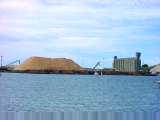
chips and logs. At 50 km I came into Burnie located on Emu Bay. With
the late start and west winds it was already mid-afternoon.
From
Penguin I continued along the coast with the scenic route merging with highway
one again. Around a bend I saw large port areas with ships loading wood
chips and logs. At 50 km I came into Burnie located on Emu Bay. With
the late start and west winds it was already mid-afternoon.