![]() One
Year By Bicycle
One
Year By Bicycle
|
|
|
|
May 21st-31st, 2001May 21st; Mackay to 22 km south of Proserpine
Costing $AUS 11.00, and an extra day and a half, I was off! Nearly 10:30am when starting out, more than four hours past my usual start. Always a little bit of an eggshell feeling on the newly fixed bike, but all rode well. Noticed that the road was typically either smooth or corrugated rough, with not much in between.
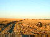
After riding 66 km for the day, pondered stopping at the Calen caravan park,
but decided to continue another 32 km. Only 22 km from Proserpine, but
wouldn't make it before sunset. Nice caravan park, though not much to eat. May 22nd; South of Proserpine to Bowen
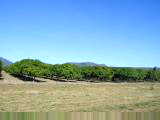
Made certain I didn't have too many stowaway passengers and set off for Proserpine. Some low haze and also remnants of smoke. Otherwise, mostly flat with cane. The 22 km to Proserpine went quickly. Nice and hungry, so had a good breakfast. At Proserpine the road forks to the Whitsunday Islands and Airlie Beach. Looks like a nice resort area. I continued straight ahead. Next 20 km of cane fields with several crossings of cane railway tracks. One area was planted with trees and a sign indicated this was for "rat prevention". Not quite certain how this works.
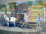
10:30am at Bowen, same time I started out the day before. Stopped in the visitor center and then rode past the salt evaporating ponds and into town. Played tourist and walked in the Bowen area. Downtown has nice wall
murals. There is a nice town jetty and beach with warning about
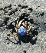
"stingers" (box jellyfish) between October and April. Walked out of town about 5 km and over
to picturesque Horseshoe Beach. Beaches in the area with hard sand and
little blue crabs (soldier crabs). The soldier crabs would scurry away until you got close and
then bury themselves in the sand. Also a fair bit of coral washed
up. Overall, an easy day ride. May 23rd; Bowen to Ayr
About 5 km out of Bowen passed Merinda site of a coal export harbor. From here another 5 km of fields before the road wound itself between low hills. The next 40 km of road had a remarkably high density of road kill. Mostly kangaroos but also hawks and remnants of small furry creatures. Couldn't exactly see why since this area was dry grazing land with few trees. At 50 km was the first service station. Four military vehicles, an ambulance, a truck and half a dozen caravans. One of the caravaners recognized me from nights before as they weren't going up the coast much quicker than I was.
After Gumlu, a service station at Mount Inkington with a friendly cat and this sign. This area was start of the cane again. At 100 km was the small town of Home Hill with a cute main street. On the far side, I rode past a sugar plant and then over a large bumpy bridge crossing the Burdekin River. The last kilometers went through thick cane and then into Ayr. A few fields were newly planted with cane, something that is done every few years. Ayr was another small town with an active downtown street. Went to the Ayr Nature Display, an exhibit hall filled with dioramas made up from different shells, butterflies, etc. The woman attending and her husband had put this collection together over 45 years. In downtown Ayr a vendor was selling "Bushman's Smoko" or quick
snacks of tea & something. The term came from a quick bite to eat
during a "smoke break" from work (at least how he explained it to the
American tourist). May 24th; Ayr to Townsville
Stopped at a service station with restrooms labeled "Mangoes" and "No Mangoes" without other clues. I picked "Mangoes". In the area following were orchards with many mango trees. The road crossed many small creeks. However, unlike further south, these creeks were more likely to have water. Several places with road construction. Unfortunately, when cars get bunched up on traffic lights, they come past in bursts, frequently trying to pass slower vehicles in their burst.
Wandered around Townsville and bought a ticket for boat trip to the Great
Barrier Reef for tomorrow. Visited a nice aquarium, The Reef HQ. The
USS Blue Ridge, a US Navy ship is in port with 1100 sailors on shore
leave. McDonalds has longer lines and the tattoo parlor has a line of
eight people waiting (not that I'm getting a tattoo, just counting lines :-)). May 25th; Rest day in Townsville
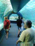
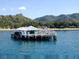
Today's destination was Kelso Reef, approximately 90 km north of Townsville on the outer reef. It took the fast catamaran slightly over two and a half hours to get to Kelso Reef. The shallowest part of the reef was covered by a meter of water and the entire area was a lighter blue-green than surrounding waters.
I picked up snorkel gear and went swimming around the reef. Amazing! Many interesting corals, fish, jellyfish, clams, sea snakes, sea cucumbers, anemone and other creatures. I was particularly enchanted by listening to parrot fish crunching coral, giant clams with little fish swimming inside and watching jellyfish float by. Tide was dropping, so swam across the shallowest parts of the reef first. Couldn't sit up, except in deeper pools. After a long snorkel, came in and ate lunch. Barbeque and a variety of potato salads. After lunch, another snorkel and then a trip on the glass bottom boat. One more short swim and our three and a half hours on the reef were up. Extra boats got tied up, client list was checked off and we took off back to Townsville. Overall, the reef trip was worthwhile. One of my neighbors on the boat
remarked he would be sore from all the swimming exercise. I didn't say
anything, but thought, "gee, this was a rest day." May 26th; Townsville to Charters Towers
Townsville was barely waking up as I cycled out of town. For the first half of today, the predominant direction was south. There were slight grades to climb leaving town. Tailwinds and flat terrain had spoiled me these past days. Slowly went over the hills. Cool cycling, even with some mist in the valleys. Along the way, saw some 50 cm high boulders in the fields, anthills, though these stopped after some time.
Another 15 km further was a Mobil roadhouse and a brunch stop. From here, the route had long gentle climbs and descents. The climbs were hard to notice, except for feeling more tired, but the descents were wonderful. Mostly grasslands with sparse trees along the way. A small range of hills to climb as I neared Mingela at 80 km. Signs indicated "Road Trains 50 meters". I had a few triple trailers pass today, but nothing too bad.
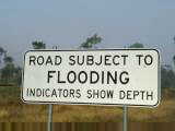
The Burdekin was but a small creek, but had flood markers all the way up. During the wet in 1997 and 1998 and many other years, flood waters were high enough over the bridge to make it impassible. Hard to imagine today looking at the small trickle. Last 20 km had some rolling hills, but nothing too bad as I came into the
"Gold City", aka Charters Towers. Most places closed on a
Saturday afternoon, but looks like a nice center. At almost 10,000 people,
this will be the largest town for a month, except for Mount Isa and Darwin. May 27th; Charters Towers to Pentland
Gentle rolling hills with surprising contrasts between cool misty low areas and warmer hilltops. Today mostly two or three types of trees and some flat areas without much trees at all. As I cycled past one wooded section, some geese took off. They were surprisingly awkward with feet out, but soon had landing gear tucked behind and looked more graceful. Also surprised a large kangaroo munching brush on the side. Cool temperatures cycling the first 43 km to Balfe's Creek. Primary business was a hotel/motel/pub/gas station. Filled up with water, 8 ppm of minerals, enough to taste but otherwise fine. Brief talk with the owner and then on the road.
Road trains today had up to four trailers behind one cab. The roads became narrower and so I had to watch out more. In a few places, there were rather poor, bumpy roads, but mostly surfaces were fine. Primary cargos appear to be cattle, ores/rock and petrol. Saw a turnoff to a copper mine nearby and many turnoffs to "stations", the term for large ranches. Next stop was Homestead at km 74. Another one store town, though there was also a small school. Proprietor at the store recommended Pentland motel over Torrens Creek, "I've been hearing about them ripping off tourists." So it was in Pentland where I stopped in the early afternoon. Hotel/motel/pub had a room for $AUS 17.00 (or ~$9 US). Pentland has a population of around 300 and a height of 397m. A caravan
park, hotel/motel/pub, antique shop, service station and a general store/post
office. Otherwise mostly quiet little town on a Sunday afternoon. May 28th; Pentland to Hughenden
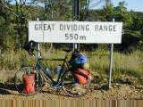
A change in landscape in the last 35 km of today. Less trees, different trees and much more open grassland. Watch out for wind! The day started with gentle climbing through forested areas. Narrow roads with a few road trains. I've decided they are worse coming from head on, partially because they are a bit of a surprise from behind (I know it is a truck, but not how long), and it seems like the blast is at least as big head on, than from behind. After 20 km, the signs said White Mountains National Park. A scenic overlook for the Great Dividing Range and elevation 550m was 10 km further.
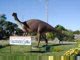
Mostly straight roads from Torrens Creek. Eucalyptus trees with some grass and cattle. Narrow and rather bumpy road surfaces for most of the 45 km to Prairie. The Prairie cafe was for sale ($AUS 170,000 including a house on 1/2 acre). Otherwise, a small settlement without much other business. Approximately 10 km past Prairie, the landscape began to change. First some of the eucalyptus were in bloom. Then, the wooded areas gave way to much more open grassy areas. When the trees came back, they were different types. Also, noticed the wind more, though fortunately it was mostly a cross-wind. I found out later that this area was known as "The Downs". Reached Hughenden at the end of a 140 km day. There was a small
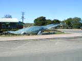
dinosaur on display at the info center. Otherwise, a big enough town to
have choice of several motels and several cafes. May 29th; Hughenden to Richmond
Filled up on water and brekky before leaving Hughenden. Better roads in this area. Very gentle climbs and descents, but mostly a straight road with power lines on one side and railroad tracks on the other. Saw a train with cars labeled "sulphuric acid" and another with mixed containers and tank cars. Most of the road trains were cattle trucks. Empty as they passed and full as they came back. A few hawks, magpies and three emus were the wildlife today. Mostly cattle country with a few sheep. Sometimes a cow would get spooked as I passed and start running, leading to more of the herd running along. Bicycle speeds were about right to be herding these cattle as I pedaled west.
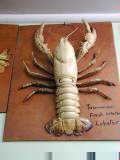
After 65 km, a small roadside rest area with picnic tables and toilets. Good place for a mid-morning snack. From here, fairly quick ride the last 47 km into Richmond. Richmond has a very interesting museum of marine dinosaur bones from the
area. The rest of town fits on two streets. Many stores closed
between 12:30pm and 1:30pm, except for two pubs that serve counter meals between
12 and 2. Post office and laundromat share a building. Three bedroom
house for $AUS 40k. May 30th; Richmond to Julia Creek
My intention had been to have brekky at the roadhouse on outskirts of town and I was there at 6:10am, ten minutes after it was posted to open. Nope, nothing yet, so I started down the road at risk of running on empty. The first 20 km out of town, saw the wonderful sunrise. Winds were calm for the first 40 km, but picked up considerably through the day. Wonderful tailwinds! Landscape was mostly golden grasslands with an occasional shrub. I saw a black and white wild pig, less cattle then yesterday and numerous birds. Also a snake road kill. The density of flies has increased. I don't think this is entirely me :-).
Mostly straight, flat and downwind until the next settlement of Neila almost 50 km further. Here a sign pointed to a Post Office and phone about a km away. The last 50 km from Neila included an obnoxious stretch of 10 km of dirt due to road construction before coming to Julia Creek. I was just in time to get a counter meal at the pub. Asked the bartender, "What is there to see in Julia Creek?" He looked at me funny, paused and said, "this is a problem, you've cycled all day from Richmond. but there isn't much to see here..." I did however walk through the main street, looked briefly at the (closed) museum and otherwise checked out Julia Creek. This area, the McKinley Shire, has a population of 1301 in an area of 40,728
km2. Industries in the area include cattle, sheep and mining. May 31st; Julia Creek to Cloncurry
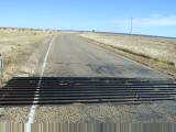
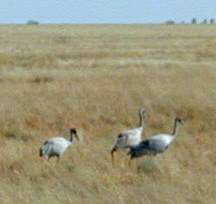
The first 95 km continued mostly open grassland and cattle grazing country. Grasses were shorter and more of a rust color. Not too far out of town, I startled an owl from beside the road and saw three kangaroos bouncing along. Saw three emus not too much further. There was a turnoff to McKinlay after 22 km. This is location of the "Walkabout Hotel", used in the film Crocodile Dundee (though the actual setting is the "top end", about 1500 km from here...I don't think there are crocodiles in McKinley). The route strayed further from the railroad and also tended to wind a bit more. As a result, had mostly tail winds, but also occasional side winds. There were multiple grids (cattle grates) to cross and several areas of open range with cattle on the road. This made bicycle cattle herding more interesting, particularly when cows running ahead decided to cross, but kept running along to keep out of way of the bicycle.
About 40 km from Cloncurry, I noticed a set of changes. It became somewhat hillier, there were termite mounds, there were quite a few more shrubs and also more red soil. All happened fairly close together. It looks like I might have reached the edge of the open grassland region for a while. Fourteen km from Cloncurry, the road from Rockhampton joined and added considerably to traffic on the road. Road surfaces were a bumpy chip-seal as I rode into Cloncurry. Cloncurry is a town of 2700. In contrast to Julia Creek, the Info Center had a guide of how to spend two days seeing everything in town. I stopped at the Mary Kathleen exhibit which had interesting machinery from this town, though I skipped the mineral museum and its $7 admission (supposed to be one of the best mineral museums around). I did pay admission to see the John Flynn exhibits. Cloncurry was site where Royal Flying Doctor Service was started by John Flynn in 1928. Very interesting exhibits and also some about the Radio School of the Air. Cloncurry became a center for some of these services to more remote bush outposts. John Flynn center was keeping tallies of where their visitors came from and
had headings for states in Australia, New Zealand, Germany, Netherlands,
Switzerland, US & Canada, Japan and "other". The majority
were fairly evenly split between Victoria, NSW and Queensland. I was their
first US tourist in May, considerably fewer than from European countries. |
|
Unless otherwise specified, this page © Copyright 2001-2002, Mike Vermeulen |
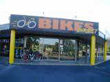
 Wobble no more! Nice to be on the road again. Today, a slightly
shorter day due to a delayed start. Slept in past sunrise for once, but
still made it to Direct Bikes in time for an 8:30am open. While the
owner/mechanic was busy working on the bike, I walked over to the Mount Pleasant
mall nearby. Had a good breakfast and mailed off the second ten days worth
of pictures. My father has copied over previous pictures through the 10th.
Wobble no more! Nice to be on the road again. Today, a slightly
shorter day due to a delayed start. Slept in past sunrise for once, but
still made it to Direct Bikes in time for an 8:30am open. While the
owner/mechanic was busy working on the bike, I walked over to the Mount Pleasant
mall nearby. Had a good breakfast and mailed off the second ten days worth
of pictures. My father has copied over previous pictures through the 10th.
 Rode
past The Leap and stopped at Kuttabul for lunch. From here, road went
through multiple drainages, gently climbing and descending for the rest of the
day. Sugar cane and more sugar cane along the way. Reasonable
shoulders, though some areas with lots of loose stones that would make a
zzzzzrrt sound as they stuck in the fenders and then broke free.
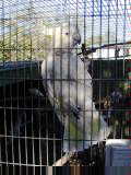
Settlements of Calen and Bloomsbury had roadhouses where I stopped. Other
towns didn't have much. Bloomsbury roadhouse had a large aviary and was
selling tropical birds.
Rode
past The Leap and stopped at Kuttabul for lunch. From here, road went
through multiple drainages, gently climbing and descending for the rest of the
day. Sugar cane and more sugar cane along the way. Reasonable
shoulders, though some areas with lots of loose stones that would make a
zzzzzrrt sound as they stuck in the fenders and then broke free.
Settlements of Calen and Bloomsbury had roadhouses where I stopped. Other
towns didn't have much. Bloomsbury roadhouse had a large aviary and was
selling tropical birds.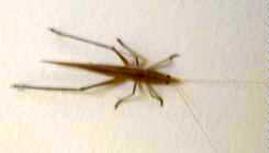
 Easy
ride today followed by sightseeing in Bowen. Caravan park had quite a bit
of insect and other life around. Ants on the floor, mozzies (mosquitos) in
the air and cricket-like creatures on the wall. Cabin had a small device
that made continuous chirping noises and high pitched sounds. Not certain
what it was supposed to ward off, but decided to keep it plugged in.
Outside bathrooms had toads hopping around. Didn't see any little gecko
lizards, but they are also prevalent here.
Easy
ride today followed by sightseeing in Bowen. Caravan park had quite a bit
of insect and other life around. Ants on the floor, mozzies (mosquitos) in
the air and cricket-like creatures on the wall. Cabin had a small device
that made continuous chirping noises and high pitched sounds. Not certain
what it was supposed to ward off, but decided to keep it plugged in.
Outside bathrooms had toads hopping around. Didn't see any little gecko
lizards, but they are also prevalent here.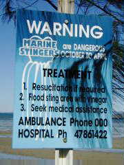
 After
20 km, the cane fields thinned out and more through forest/scrub area. One
service station at km 34 was selling local rock melons (cantelopes) and other
vegetables. Next stretch had an area with a small grass fire that was
attended and I believe deliberate. Some road with loose stones and then I
was already at Bowen.
After
20 km, the cane fields thinned out and more through forest/scrub area. One
service station at km 34 was selling local rock melons (cantelopes) and other
vegetables. Next stretch had an area with a small grass fire that was
attended and I believe deliberate. Some road with loose stones and then I
was already at Bowen.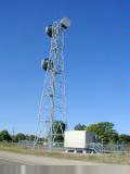
 Flat
terrain along the coast resulted in another easy ride today. Time of first
reasonable light has slowly been shifting later as I head slightly westward and
as winter comes. At least two people remarked about the "nippy"
morning. Found it strange since it was at least 10°C (50°F).
Flat
terrain along the coast resulted in another easy ride today. Time of first
reasonable light has slowly been shifting later as I head slightly westward and
as winter comes. At least two people remarked about the "nippy"
morning. Found it strange since it was at least 10°C (50°F).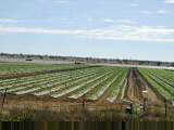
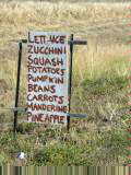
 At
65 km passed Gumlu. Some orchards with mango trees and also vegetables
covered in plastic. This area has a very productive aquifer (liquid gold)
used for irrigation as most rain falls during the summer. A lot of fruit
harvesting is done by "backpackers". Apparently a good way for
Australian, European and other youth to travel and also raise funds along the
way. Local papers carry a story of a wage dispute between British
backpackers and a local mango grower.
At
65 km passed Gumlu. Some orchards with mango trees and also vegetables
covered in plastic. This area has a very productive aquifer (liquid gold)
used for irrigation as most rain falls during the summer. A lot of fruit
harvesting is done by "backpackers". Apparently a good way for
Australian, European and other youth to travel and also raise funds along the
way. Local papers carry a story of a wage dispute between British
backpackers and a local mango grower.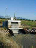
 An
easy ride to the big city of Townsville. Main street Ayr still quiet as I
rode out of town. Today mostly irrigated farming area of sugar cane and
mangoes. Most of the fields with large pumps to bring up water.
After Ayr was Brandon and then countryside. In the distance, some taller
hills that I approached and then skirted around.
An
easy ride to the big city of Townsville. Main street Ayr still quiet as I
rode out of town. Today mostly irrigated farming area of sugar cane and
mangoes. Most of the fields with large pumps to bring up water.
After Ayr was Brandon and then countryside. In the distance, some taller
hills that I approached and then skirted around.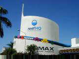
 Fairly
quickly came to Alligator Creek roadhouse and thereafter to the Townsville info
center. In between was a large zinc plant and also Australia's largest
copper plant. At the info center, found a detailed route the last 10 km
into town. Nice motel, though I had to carry my bicycle up four flights of
steps. Seem to be in the bar district with one tavern named "The Mad
Cow". I suspect that name wouldn't do well in Britain right now.
Fairly
quickly came to Alligator Creek roadhouse and thereafter to the Townsville info
center. In between was a large zinc plant and also Australia's largest
copper plant. At the info center, found a detailed route the last 10 km
into town. Nice motel, though I had to carry my bicycle up four flights of
steps. Seem to be in the bar district with one tavern named "The Mad
Cow". I suspect that name wouldn't do well in Britain right now.
 Today
a rest day and trip to the Great Barrier Reef. The reef consists of around
2500 different reefs stretching over 2000 km from Cape York in the north to
Bundaberg in the south. Generally where water temperatures are over
20°C. All together, the Great Barrier Reef is the most massive structure
built by living creatures and can be seen from the moon.
Today
a rest day and trip to the Great Barrier Reef. The reef consists of around
2500 different reefs stretching over 2000 km from Cape York in the north to
Bundaberg in the south. Generally where water temperatures are over
20°C. All together, the Great Barrier Reef is the most massive structure
built by living creatures and can be seen from the moon.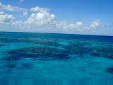
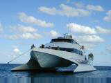 After
the catamaran anchored, a set of separate activities were possible. One
group went in a fishing boat. A second group went scuba diving in deeper
water. A glass bottom boat went cruising with a marine biologist.
Snorkel gear was also provided.
After
the catamaran anchored, a set of separate activities were possible. One
group went in a fishing boat. A second group went scuba diving in deeper
water. A glass bottom boat went cruising with a marine biologist.
Snorkel gear was also provided. On
the road again! This time westward and even southward as I started towards
the outback of Queensland. Most of Australia is considered
"outback", all except for populated east and west coasts and
Tasmania. Not quite certain where it begins, but saw my first ant hills
and first road trains today.
On
the road again! This time westward and even southward as I started towards
the outback of Queensland. Most of Australia is considered
"outback", all except for populated east and west coasts and
Tasmania. Not quite certain where it begins, but saw my first ant hills
and first road trains today.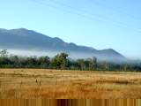 Bars
in Townsville must close at 4am, given the amount of noise and commotion
outside. I carefully carried my bicycle down four flights of steps to
discover that I needed my room key to get out a locked door. Back to my
room and then out.
Bars
in Townsville must close at 4am, given the amount of noise and commotion
outside. I carefully carried my bicycle down four flights of steps to
discover that I needed my room key to get out a locked door. Back to my
room and then out.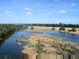 At
40 km, Woodstock service station was my first stop. Dust covered
everything that wasn't refrigerated, so this was a quick stop. They've
been refrigerating chocolate bars throughout most of Queensland.
At
40 km, Woodstock service station was my first stop. Dust covered
everything that wasn't refrigerated, so this was a quick stop. They've
been refrigerating chocolate bars throughout most of Queensland. I
had heard of a roadhouse near Mingela and was eagerly awaiting it as I
climbed. Nothing on top or until I passed the Burdekin River at 114 km.
I
had heard of a roadhouse near Mingela and was eagerly awaiting it as I
climbed. Nothing on top or until I passed the Burdekin River at 114 km.
 Short
day riding without much variety. Charters Towers surprisingly alive as I
rode through just past 6 am. Newsagent store open. Had breakfast at
McDonalds and then headed out of town. Just outside town were large sale
yards filled with cattle and a notice that the next auction would occur on May
30th. I've been seeing road trains and railway cars bringing out cattle
now that dry season has started.
Short
day riding without much variety. Charters Towers surprisingly alive as I
rode through just past 6 am. Newsagent store open. Had breakfast at
McDonalds and then headed out of town. Just outside town were large sale
yards filled with cattle and a notice that the next auction would occur on May
30th. I've been seeing road trains and railway cars bringing out cattle
now that dry season has started.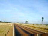
 Approximately
10 km further, a van pulled alongside as I was cycling. About eight young
adults inside and cargo trailer on behind. We had a brief
conversation. Turns out, they were Christian evangelists on tour.
They asked if they could do a blessing. I said, fine and so they gave a
brief blessing of myself and bicycle trip. Shortly thereafter, someone
yelled, "road train!" and off the van zoomed.
Approximately
10 km further, a van pulled alongside as I was cycling. About eight young
adults inside and cargo trailer on behind. We had a brief
conversation. Turns out, they were Christian evangelists on tour.
They asked if they could do a blessing. I said, fine and so they gave a
brief blessing of myself and bicycle trip. Shortly thereafter, someone
yelled, "road train!" and off the van zoomed.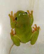
 There
was a frog in the toilet under the rim. Flushing was sufficient to bring
him into the bowl, but not back down the drain. Not certain if he was
otherwise harmful, so I left him to crawl back to his perch to delight the next
visitor.
There
was a frog in the toilet under the rim. Flushing was sufficient to bring
him into the bowl, but not back down the drain. Not certain if he was
otherwise harmful, so I left him to crawl back to his perch to delight the next
visitor.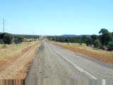
 The
next 25 km, the road was almost completely straight, with only gentle
grades. This brought me to Torrens Creek and a brekky break of sausage,
eggs, toast, tomato and a pot of tea. I had breakfast with another guest,
an American who moved from LA to Cairns 24 years ago, and now did odd jobs and
enjoyed the more relaxed lifestyles.
The
next 25 km, the road was almost completely straight, with only gentle
grades. This brought me to Torrens Creek and a brekky break of sausage,
eggs, toast, tomato and a pot of tea. I had breakfast with another guest,
an American who moved from LA to Cairns 24 years ago, and now did odd jobs and
enjoyed the more relaxed lifestyles.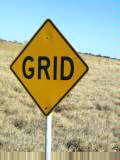
 Home
on the Aussie range, where sheep, roos and cattle graze...Still needs some work
:-). Today, riding through open grassland without much in the way of
trees. Today starts and area of what I'll call "one day-ers",
meaning no places for water or provisions except at beginning and end of the
day. I packed five liters of water today. However, favorable
tailwinds made it a pretty easy day, only two liters consumed and in Richmond by
12:30pm. After Mount Isa, I expect a few "two day-ers".
Home
on the Aussie range, where sheep, roos and cattle graze...Still needs some work
:-). Today, riding through open grassland without much in the way of
trees. Today starts and area of what I'll call "one day-ers",
meaning no places for water or provisions except at beginning and end of the
day. I packed five liters of water today. However, favorable
tailwinds made it a pretty easy day, only two liters consumed and in Richmond by
12:30pm. After Mount Isa, I expect a few "two day-ers".
 After
about 30 km, the wind started picking up. A glorious tailwind! This
open range will make wind more of a factor, and I was lucky today.
After
about 30 km, the wind started picking up. A glorious tailwind! This
open range will make wind more of a factor, and I was lucky today.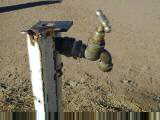
 Today
a long, but not too difficult one day-er with more wonderful tailwinds. A
beautiful sunrise today. Landscape was golden colored as no rain has
fallen since March. I watched the stars slowly go away and reds and blues
on the horizon as the sun slowly come up on the golden fields from behind me.
Today
a long, but not too difficult one day-er with more wonderful tailwinds. A
beautiful sunrise today. Landscape was golden colored as no rain has
fallen since March. I watched the stars slowly go away and reds and blues
on the horizon as the sun slowly come up on the golden fields from behind me.
 At
50 km, was a roadside rest area. Maximum stay was 48 hours, though it
looked a bit bleak to stay for even 24 hours. There was a water spigot,
though I'd carried six liters today (and consumed two). This place was
named Maxwellton and had a few houses, though no commercial establishments.
At
50 km, was a roadside rest area. Maximum stay was 48 hours, though it
looked a bit bleak to stay for even 24 hours. There was a water spigot,
though I'd carried six liters today (and consumed two). This place was
named Maxwellton and had a few houses, though no commercial establishments.
 A
one day-er with a big change in landscape today. I was able to get brekky
at the roadhouse out of town before leaving, so it was nice and light when I
left.
A
one day-er with a big change in landscape today. I was able to get brekky
at the roadhouse out of town before leaving, so it was nice and light when I
left.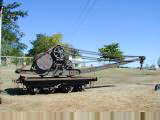 Stopped
briefly at rest area at 70 km. Again, this had a water faucet, though I'd
brought more than enough for a full day. This area crossed several
creeks. Some were empty, some a chain of water holes and a few were
full. The creeks meant more trees.
Stopped
briefly at rest area at 70 km. Again, this had a water faucet, though I'd
brought more than enough for a full day. This area crossed several
creeks. Some were empty, some a chain of water holes and a few were
full. The creeks meant more trees.