![]() One
Year By Bicycle
One
Year By Bicycle
|
|
|
|
May 11th-20th, 2001May 11th; Brisbane to Caboolture
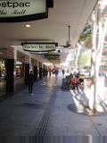
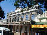
Cycled with Rob into the center of Brisbane, his normal commute route. Nice cycle path along the highway and then along the river. Brief stretch on side of the freeway. We parted company at downtown Brisbane. I cycled further and through the botanic gardens and also walked through the downtown Queen Street pedestrian mall.
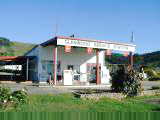
The Bruce Highway is the main road and goes 1700km from Brisbane to Cairns. This will be my route for the next few weeks. At this point, the Bruce Highway as two busy lanes each way. I decided to ride the highway the last 8km to see the road so far. Definitely busy and with less shoulders than the Pacific Highway. In those 8km, two segments with road construction and thus jersey barriers along the left instead of shoulders. Stopped in Caboolture. An early stop, but now already outside Brisbane
and heading outbound. May 12th; Caboolture to Gympie
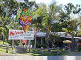
I got off the highway to take the tourist route through Nambour. First stop was a 15 meter high fiberglass pineapple, appropriately named "The Big Pineapple". Inside the three story pineapple were exhibits about tropical fruits. Outside were little pineapples on a plantation.
Shortly after I rejoined the Bruce Highway again, it became just a single
lane with occasional overtaking lanes. For most of the next 40 km, the
road wound its way through hilly area with forests and ranches, but no
commercial establishments. At 10 km south of Gympie was a large roadside
complex, the Matilda rest area. This had shops, petrol (gasoline),
etc. Apparently, stocks of diesel will be in short supply here.
Partially due to joint US/Australian military exercises and partially due to
refinery problems. Stopped for a late lunch and then cycled last 10km to
Gympie for the day. May 13th; Gympie to Maryborough
Fog in the low areas and fairly chilly starting out. Most motels seem to have space heaters, so never really expect to get very cold. Somewhat open terrain with cattle. Bike was riding well though I'd needed to tighten a rear spoke and raise the seat slightly. About 15km into the ride, came to Gunalda. I'd been seeing signs for "Windsong" including a cafe, so eagerly pedaled there to find they were not yet open. Instead climbed over a low hill and stopped briefly at roadside area of Glenwood. I've been seeing signs for a tropical fruit, spelled both "paw-paw" and "papaw". The Glenwood Service Station had jams made with various tropical fruits.
From Tiaro, ranching lands gave way to pineapple, sugar cane and other
crops. Nice visitor stop outside Maryborough. Nearby a winery and
also a big fruit packing factory. Cycled into town for lunch. Made
it an early day and wandered around town. Sunday and most shops were
closed, but still a nice museum and historic buildings. May 14th; Maryborough to Gin Gin
Lots of forest cycling today. North of Maryborough was Wolgi State Forest with pine trees neatly planted in rows. Later mostly eucalyptus along the way. Shoulders continue to be intermittent. Forest riding went quickly without side distractions. Turnoffs to small towns of Torbanlea and Howard after 30 km. From here, forest again for 20 km and the Isis River. Crossing the Isis River, noticed orange trees in big nets. Also, a quarantine sign to prevent transport of banana or cane plants. Town of Childers was situated on a ridge. Cute downtown with many shops. Childers gained notoriety June 23rd, 2000 when an arsonist burned down the backpacker hostel in center of town, resulting in fifteen lives lost. Apparently, this hostel helped some backpackers find migrant work picking fruits in the area and the fatalities were all fruit pickers under age thirty. I found the hostel along the main street and paused briefly at the memorial.
From the road junction, continued through woods for 20 km to Booyal and short
lunch stop at a roadside service station. Last 25 km had more sugar cane,
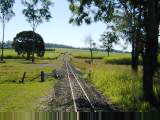
including areas with a narrow gauge cane railway. Stopped at the small
town of Gin Gin. Walked through main business district in 15 minutes. May 15th; Gin Gin to Benaraby
Today was a four water bottle day. Normally, two bottles is enough with frequent places to fill up. However, no such places expected until Miriam Vale at 99 km. Sparsely wooded terrain, with grassland and cattle along the way. Long rolling hills that included gradual climbs and corresponding long glides downhill. Quite a bit of caravan traffic and truck traffic. Stopped briefly at 18 km at turnoff to the dam and continued down the road.
From Miriam Vale, the terrain followed the railroad tracks and was
flatter. Still quiet with only a small burg of Bororen before I came to
Benaraby. Several military vehicles passing as US and Australia are having
joint military exercises in the area. This and some refinery problems are
causing Queensland a potential short term shortage of diesel fuel. Felt
good to stop after a long day. May 16th; Benaraby to Rockhampton
Today busy riding along the Bruce Highway. Many motels here have meal service. I have dinner, but frequently leave before breakfast. Instead, stopped briefly in Calliope at 16 km. Another quick stop 7 km later when signs said historical village. Wasn't officially open yet, but dropped by admission fee in the tin and took a quick look around at old historic buildings and train cars. From there, straightforward riding through wooded terrain. Cows with large humps would frequently take a look at my bicycle, pause for a bit, and then decide to stampede away from this strange beast. Rockhampton is known as the "beef capital" of Australia. Australian beef has been doing well, partially because of hoof-n-mouth disease has inhibited european beef. Stopped again at Mount Larcom, known for its pies.
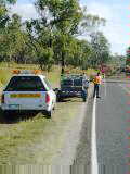
Shoulders were mostly narrow with a fair amount of truck traffic. Also a few occasions of huge construction equipment being moved as "wide loads". These loads would be preceded by a pilot car and a police car with flashing lights. Otherwise, most trucks gave me good room. After Mount Larcom, went through several small places before coming to the
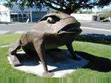
big metropolis (~60,000 people) of Rockhampton. There were several cow
statues, a visitor center at the Tropic of Capricorn and some nice downtown
shops. Found a nice place downtown. May 17th; Rockhampton to Marlborough
Left "Rocky" as the route followed a 50cm wide aboveground pipe for about 25 km. Not certain if this is water or something else. Also, railroad tracks through only two trains today. After 25 km, a turnoff to The Caves, some natural limestone caverns. Another 11 km later, Yaamba had a service station and a hotel. Stopped in and stocked up. Light fog in this stretch. At 50 km for the day was a roadside marker commemorating the gold discoveries in 1858 that brought numerous settlers to the area and led to the start of Rockhampton. Another 10 km later was a turnoff to a mine as part of the "Queensland Magnesia Project", presumably a manganese mine. This area was considerably more open which allowed the wind to pick up.
May 18th; Marlborough to Carmila
Today a ride back from beef to cane and bananas, though changing slowly. Previous evening a front had come through, dropped some rain and generally cooled things off. Estimate about 10° C (59° F) instead of 15° C these past few mornings. Felt great to ride in cool morning air through the forest. A slight crosswind, though that started changing more to tailwind. Perfect morning! Made good time, pausing briefly at the closed Tooloombah Roadhouse at 35 km. Short while later, met a cyclist coming from Cairns and going to Melbourne. Traded road information and also stayed out of the way of a huge "Wide Load" boat carried on trailer.
First real water stop was a roadhouse at 88 km. Their specialty was big burgers, though it didn't hit home until I saw that "big" meant a burger that seemed almost as large as my head. Most of the terrain until now had been sparsely wooded with cattle. This started to change as I came past first banana plants in several hundred kilometers. Also came close to the coast for first time in a week. Beautiful blue-green waters with small islands offshore. Almost tempting enough to stop, but put in another 30 km to stop at Carmila. Carmila is a small town surrounded by sugar cane. Library is open two
afternoons a week. Small Anglican church and a Catholic church that has
mass once a month. May 19th; Carmila to Mackay
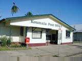
Easy ride today, mostly flat with some tailwinds. Road surfaces are somewhat rough. Not bumpy rough, but instead larger chips and not as much tar on the road. Mackay harbor handles approximately a third of the Australian sugar exports and there were plenty of cane fields along the way. Cane plants were almost three meters high. Apparently, the "crush" will start at end of next week. From Carmila, followed the railroad tracks over past Orkabie and Ilbilbie sidings to the small town of Koumala. A store, post office, pub/hotel and community building were the main establishments in town. Outdated postings for a local basketball league with six teams.
From Sarina, a bit more tailwind to blow me through the cane and fairly
quickly the last 35 km to Mackay. Stopped here at a visitor information
center to get town information. The town itself had a large mall, "Caneland"
(closes at 3pm on Saturday) and many small shops including an internet
cafe. Otherwise seemed like a fairly sleepy town. May 20th; Mackay to North Mackay via Kuttabul
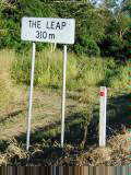
Nice cool morning starting out. Smooth roads and light winds from the side. Tall and lush cane along the way. Unlike corn, seems like the tall plants grow right to the sides of the field. Sunny and nice day riding. Stopped in for breakfast two kms down the road and then passed North Mackay with large shopping center and cinema. Then out of town and along the small burg of Farleigh. Road passed a rock outcropping, "The Leap" and a shop selling sapphires.
Tightened up all spokes on the left by half turn and investigated the wobble further. I might be able to remove the worst of the wobble, though truing wheels, particularly on the road, is awkward. Figured if Bowen had a bike store, might stop by tomorrow 150 km down the road. Unfortunately, Yellow Pages listed no bike shops northbound for the next 200 km and thus likely to Townsville almost 400 km away. Decided to be very cautious and turn back to Mackay with its four bike shops. On a previous trip across Canada, I'd broken three rear rims. This time, I wanted to avoid weakening this rim, and wobble into Townsville, just prior to heading into the outback. Instead, having a professional with truing stand get wheel into solid shape was worth some peace of mind. Pretty cautious, but I had some extra time in the schedule. Turned around and saw scenery from the other direction. Passed Wade
Hatler who must have been keeping close to a similar route. Climbed up
past The Leap. Side winds or perhaps slight tailwinds. Stopped in
North Mackay. Bike shop (and most other shops) closed on Sunday, but open
tomorrow morning at 8:30am. They'll have a client waiting.
Otherwise, relax here and walk over to shops and cinema.
|
|
Unless otherwise specified, this page © Copyright 2001-2002, Mike Vermeulen |
 Nice visit with Becky, Rob and their children: Tim, Grace and Daniel.
Thanks! Picked and ate passion fruit from the garden, yum! Got some
of my Australia questions answered. Bowling clubs have lawn bowling.
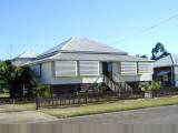
Queensland style houses are built high to allow cool breezes to blow underneath.
Nice visit with Becky, Rob and their children: Tim, Grace and Daniel.
Thanks! Picked and ate passion fruit from the garden, yum! Got some
of my Australia questions answered. Bowling clubs have lawn bowling.
Queensland style houses are built high to allow cool breezes to blow underneath.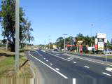 Heading
out of the city center, I followed local roads. Winding back and forth
with short hills. Traffic congestion was variable, but all went fairly
quickly. Stopped briefly at a park in Petrie and then came to the Bruce
Highway.
Heading
out of the city center, I followed local roads. Winding back and forth
with short hills. Traffic congestion was variable, but all went fairly
quickly. Stopped briefly at a park in Petrie and then came to the Bruce
Highway.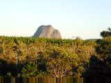
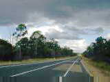
 Good day riding along the Bruce Highway. Road started as an expressway
with two lanes each direction and reasonable shoulders. I was also a bit
of an "express" cyclist and the road was mostly flat and going through
pine forests. I bypassed exits for the volcanic Glass House mountains
shown above left and most of the Sunshine Coast attractions such as a honey
farm, Aussie World, etc. The Sunshine Coast is name for a set of towns
~100km north of Brisbane, not quite as commercial as the Gold Coast.
Good day riding along the Bruce Highway. Road started as an expressway
with two lanes each direction and reasonable shoulders. I was also a bit
of an "express" cyclist and the road was mostly flat and going through
pine forests. I bypassed exits for the volcanic Glass House mountains
shown above left and most of the Sunshine Coast attractions such as a honey
farm, Aussie World, etc. The Sunshine Coast is name for a set of towns
~100km north of Brisbane, not quite as commercial as the Gold Coast.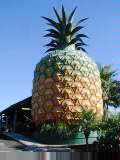
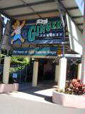
 Nambour
had hills to climb and descend and also a small downtown area. From here,
I followed the tourist drive to Yandina, site of the world's largest ginger
factory. Giant vats of ginger being processed here. Also a tourist
shop and garden area.
Nambour
had hills to climb and descend and also a small downtown area. From here,
I followed the tourist drive to Yandina, site of the world's largest ginger
factory. Giant vats of ginger being processed here. Also a tourist
shop and garden area.
 An easy ride today on Mother's Day. I had been told to watch for hills
near Gympie. When it was fairly easy yesterday, I expected them today, but
today was slightly rolling terrain that was even easier than yesterday.
Both were easier than Brisbane.
An easy ride today on Mother's Day. I had been told to watch for hills
near Gympie. When it was fairly easy yesterday, I expected them today, but
today was slightly rolling terrain that was even easier than yesterday.
Both were easier than Brisbane.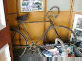
 Second
half of the ride had very little shoulders, with occasional overtaking
lanes. Town of Tiaro was slightly larger and good place for a stop.
Notice that many buildings capture rainwater from the roof into a large tank.
Second
half of the ride had very little shoulders, with occasional overtaking
lanes. Town of Tiaro was slightly larger and good place for a stop.
Notice that many buildings capture rainwater from the roof into a large tank.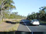
 Yesterday evening had dinner with Rob's brother Tom and wife Cathy.
Pasta and prawns, good! I've been seeing lots of signs for prawns, both as
food and as bait (with bait considerably cheaper). Found out that
"paw paw" is a shortened form of "papaya". Maryborough
is a nice town of ~25,000 that started as one of the main ports of entry and
trade to new colony of Queensland. It was the primary alternative to the
convict port of Brisbane and at one point was under consideration as the capital
city. Since then, stayed mostly the same size, while Brisbane has grown.
Yesterday evening had dinner with Rob's brother Tom and wife Cathy.
Pasta and prawns, good! I've been seeing lots of signs for prawns, both as
food and as bait (with bait considerably cheaper). Found out that
"paw paw" is a shortened form of "papaya". Maryborough
is a nice town of ~25,000 that started as one of the main ports of entry and
trade to new colony of Queensland. It was the primary alternative to the
convict port of Brisbane and at one point was under consideration as the capital
city. Since then, stayed mostly the same size, while Brisbane has grown.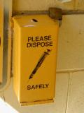
 Seven
kilometers past Childers was a small park where the road split off to Bundaberg.
Ate an apple and went to throw away the core at the restroom. No waste
basket, though it did have a hypodermic needle disposal, strange and a little
creepy.
Seven
kilometers past Childers was a small park where the road split off to Bundaberg.
Ate an apple and went to throw away the core at the restroom. No waste
basket, though it did have a hypodermic needle disposal, strange and a little
creepy.
 Last evening had dinner with
 Quiet
and quickly riding led me to a roadside rest area after 60 km. Several
caravans parked. Looks like a popular way to visit Australia. From
here, started to get warmer, but fairly quickly rode the last 40 km to Miriam
Vale with two water bottles to spare. TV was playing some sort of American
talk show of the type where they bring in people and surprise them with
outlandish things.
Quiet
and quickly riding led me to a roadside rest area after 60 km. Several
caravans parked. Looks like a popular way to visit Australia. From
here, started to get warmer, but fairly quickly rode the last 40 km to Miriam
Vale with two water bottles to spare. TV was playing some sort of American
talk show of the type where they bring in people and surprise them with
outlandish things.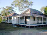
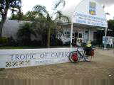
 Reached the tropics today. Crossing 23° 26' 30", brought me
across the Tropic of Capricorn and officially into the region where the sun
passes directly overhead at some point in the year (here on the longest day,
~December 21st).
Reached the tropics today. Crossing 23° 26' 30", brought me
across the Tropic of Capricorn and officially into the region where the sun
passes directly overhead at some point in the year (here on the longest day,
~December 21st).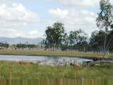
 This
next region was looking drier, even saw a prickly pear cactus. Apparently,
this is a combination of normal climate differences and also a dry year this
year. Also a very active electrically powered railroad in this area.
I counted at least eleven trains passing. A few were carrying coal from
mines near Blackwater to Gladstone harbor. Others carried containers.
This
next region was looking drier, even saw a prickly pear cactus. Apparently,
this is a combination of normal climate differences and also a dry year this
year. Also a very active electrically powered railroad in this area.
I counted at least eleven trains passing. A few were carrying coal from
mines near Blackwater to Gladstone harbor. Others carried containers.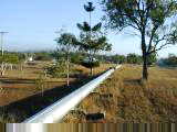
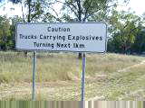
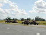 Cattle country again today. Otherwise, sparsely populated with not much
in the way of towns north of Rockhampton. Still quite a few military
vehicles on the roads as part of the "Tandem Thrust" war games in the
area. Newspapers reported a bit of a fuss, as American troops had shot and
killed an emu (oops). They were given pictures of native wildlife such as
kangaroos and crocodiles and told to be careful, though no pictures of
emus. On the other hand, papers also report that business is good with
troops ordering an extra 4000 pizzas, 16000 burgers and 20000 doughnuts so
far. Extra pepperoni is being brought into town.
Cattle country again today. Otherwise, sparsely populated with not much
in the way of towns north of Rockhampton. Still quite a few military
vehicles on the roads as part of the "Tandem Thrust" war games in the
area. Newspapers reported a bit of a fuss, as American troops had shot and
killed an emu (oops). They were given pictures of native wildlife such as
kangaroos and crocodiles and told to be careful, though no pictures of
emus. On the other hand, papers also report that business is good with
troops ordering an extra 4000 pizzas, 16000 burgers and 20000 doughnuts so
far. Extra pepperoni is being brought into town.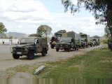 Rode
into the wind and stopped briefly at the service station before climbing over a
hill and into the next valley. Still early when arrived in Marlborough,
but limited choices in the area. Expect tomorrow to be a four water bottle
day.
Rode
into the wind and stopped briefly at the service station before climbing over a
hill and into the next valley. Still early when arrived in Marlborough,
but limited choices in the area. Expect tomorrow to be a four water bottle
day.
 Last night had dinner with a couple from NSW who were returning from a
caravan holiday up north. Always interesting to get some travel tips and
descriptions of country and history. Most of the folks I've met with
caravans are either from Europe (Germany, Austria and Switzerland are popular)
or older folks from further south in Australia. Caravan park owner said he
really enjoyed seeing all the yellow (NSW) and white (Victoria) plates as the
weather got cold down south.
Last night had dinner with a couple from NSW who were returning from a
caravan holiday up north. Always interesting to get some travel tips and
descriptions of country and history. Most of the folks I've met with
caravans are either from Europe (Germany, Austria and Switzerland are popular)
or older folks from further south in Australia. Caravan park owner said he
really enjoyed seeing all the yellow (NSW) and white (Victoria) plates as the
weather got cold down south.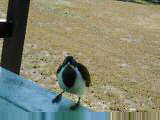
 After
65 km was a roadside rest area with restrooms and places to park/camp
overnight. Water had signs to boil first though. Finished some
cookies and also fed cookie bits to eager birds.
After
65 km was a roadside rest area with restrooms and places to park/camp
overnight. Water had signs to boil first though. Finished some
cookies and also fed cookie bits to eager birds.
 Australian pronunciation tip: Mackay rhymes with "pie" and not
"pay". Of course, if you are an Aussie, then "pay"
does rhyme with Mackay :-). This is a regional center of 70,000 residents,
though doesn't feel that big. Perhaps because many places already shut
down on a Saturday afternoon.
Australian pronunciation tip: Mackay rhymes with "pie" and not
"pay". Of course, if you are an Aussie, then "pay"
does rhyme with Mackay :-). This is a regional center of 70,000 residents,
though doesn't feel that big. Perhaps because many places already shut
down on a Saturday afternoon.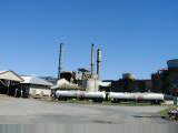
 Next
town was Sarina. Sarina had a large sugar distillery where they make
ethanol among other products. In Sarina, noticed signs of other world
travelers.
Next
town was Sarina. Sarina had a large sugar distillery where they make
ethanol among other products. In Sarina, noticed signs of other world
travelers. 
 Today an unforseen day in Mackay (remember, this doesn't rhyme or at least
the way you think it does :-)).
Today an unforseen day in Mackay (remember, this doesn't rhyme or at least
the way you think it does :-)). Just
past a turnoff to Marian, on some smooth road, I noticed an asymmetry in
riding. Investigated and found the rear wheel out of true with a
distinctive wobble. Not certain how long that has been developing.
No broken spokes, though the left side was looser than the right. Rode a
few kms further to Kuttabul general store to take a look.
Just
past a turnoff to Marian, on some smooth road, I noticed an asymmetry in
riding. Investigated and found the rear wheel out of true with a
distinctive wobble. Not certain how long that has been developing.
No broken spokes, though the left side was looser than the right. Rode a
few kms further to Kuttabul general store to take a look.