

September 1st-10th, 2001
Map 26
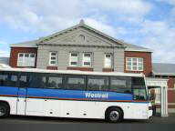
September 1st; Cataby Roadhouse to Western Flora
Caravan Park
 Weather
forecast said "isolated showers." I must have visited most of
those showers this morning. Off and on drizzle as I rode from one shower
to the next.
Weather
forecast said "isolated showers." I must have visited most of
those showers this morning. Off and on drizzle as I rode from one shower
to the next.
Overcast skies meant it was still dark as I left, though quickly getting
light. More hills today, particularly between Badgingarra and Eneabba.
Many low scrub trees, but also occasional grazing lands and some wheat.
The Brand Highway had been completed in 1975, so not much in the way of towns.
From Cataby rode 30 km to Cervantes turnoff (52 km). Cervantes is next
to Pinnacle Desert, large limestone pinnacles. Looked intriguing, though a
bit far for a detour.
Another 12 km brought me to Badgingarra. I was ready to dry off, rest
up and eat brekky. Nice stop at the roadhouse here. After brekky,
another 43 km on rolling hills to Halfway Mill Roadhouse and another stop.
There was a long climb out of Halfway Mill, but then it became flatter.
The drizzle also mostly stopped by then. Wind picked up, though was
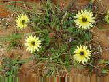
fortunate to have mostly tail wind. Many wildflowers in bloom, so was a
pretty ride through this stretch. Another 30 km to Eneabba. Eneabba
is where 80% of the world's rutile mineral sand is found.

 After
Eneabba a last 22 km to Western Flora Caravan Park. The next indoor
accommodation would be another 59 km further on, so ready for a stop.
After
Eneabba a last 22 km to Western Flora Caravan Park. The next indoor
accommodation would be another 59 km further on, so ready for a stop.
Got a donga accommodation. At 4:30 pm I went on the "wildflower
walk" from the park. Met some caravaners I had first seen at Mary
Pool a month and a half ago! Wildflower walk was very well done and
finished with a show at the dissecting microscope. Afterwards enjoyed a
nice dinner with four others (caravan park had taken reservations before).
137 km today, 15205 km cumulative.
September 2nd; Western Flora Caravan Park to
Geraldton

 Rode
back to Geraldton today, so ready to stop by bike shop tomorrow when it
opens. Rode through two rain showers, but afternoon sun came out and much
nicer weather. Today is father's day in Australia, unlike June for the US.
Rode
back to Geraldton today, so ready to stop by bike shop tomorrow when it
opens. Rode through two rain showers, but afternoon sun came out and much
nicer weather. Today is father's day in Australia, unlike June for the US.
Early departure again from the caravan park. Gentile rolling hills with
pastures, sheep, wheat and trees. More farming from Dongara to Geraldton
than the first part of the day.
Bicycle continued to ride smoothly. Rode almost half the distance, 59
km, before stopping in Dongara for brekky. Brief rain showers both before
and after the stop. Mostly cross winds.
Map 25
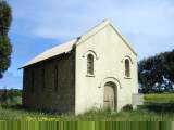
Another 49 km past Dongara was historic hamlet of Greenough. Eleven of
the historic buildings have been restored and are open for viewing. The
hamlet included an Anglican Church, Catholic Church, Police station & jail
& courthouse, school and several houses.
 After
Greenough, quickly rode the last kms and arrived in Geraldton early in the
afternoon. Plan is to use some of the better parts from the other bike and
then pack things up to start heading anti-clockwise again.
After
Greenough, quickly rode the last kms and arrived in Geraldton early in the
afternoon. Plan is to use some of the better parts from the other bike and
then pack things up to start heading anti-clockwise again.
Stayed in the same hostel, though this time my room was formerly the women's
ward of the hospital (last time it was the former pantry).
124 km today, 15329 km cumulative.
September 3rd; Rest day in Geraldton
 Today a day at the bike shop. Darryl spent much of the day with my bike
and things now look better. We transferred bottom bracket, cranks and
front derailleur...and switched them back since widths on the previous frame
were wider, resulting in poor shifting. We switched over the front rack,
front wheel, stem and cyclometer. Darryl also replaced cables and a broken
brake adjustment screw.
Today a day at the bike shop. Darryl spent much of the day with my bike
and things now look better. We transferred bottom bracket, cranks and
front derailleur...and switched them back since widths on the previous frame
were wider, resulting in poor shifting. We switched over the front rack,
front wheel, stem and cyclometer. Darryl also replaced cables and a broken
brake adjustment screw.
Rode about 5 km in adjustment rides, though doesn't count in the cumulative
total. I did learn that left turn on red isn't allowed in Australia.
Halfway around and time to ask these road rules...
 Picked up the rest of my gear and packed a full load on the bike again.
Fifteen days ago rolled into Geraldton and now ready to ride anti-clockwise
again!
Picked up the rest of my gear and packed a full load on the bike again.
Fifteen days ago rolled into Geraldton and now ready to ride anti-clockwise
again!
0 km today, 15329 km cumulative.
September 4th; Geraldton to Three Springs
 Beautiful
day of riding. Clear skies, not much traffic and pretty country
landscapes. Darryl had given me directions for the back route to Mingenew
(Edwards Road, Allanooka Springs Road and Depot Hill Road for those with a
detailed map). From Mingenew I was on the "old" highway to
Perth. Yet another "new" highway is being built along the coast,
so eventually the in between route will also get quieter. Except for the
first 2 km, it was thus all landscapes I hadn't seen before.
Beautiful
day of riding. Clear skies, not much traffic and pretty country
landscapes. Darryl had given me directions for the back route to Mingenew
(Edwards Road, Allanooka Springs Road and Depot Hill Road for those with a
detailed map). From Mingenew I was on the "old" highway to
Perth. Yet another "new" highway is being built along the coast,
so eventually the in between route will also get quieter. Except for the
first 2 km, it was thus all landscapes I hadn't seen before.
Packed everything early before the hostel office opened. Out to the
traffic circle and heading towards the airport before turning onto Edwards Road
at 6 km. Reasonable amounts of traffic as I passed industrial parts of
Geraldton. However, fields and farm landscapes soon thereafter.
Mostly sheep with a few cows. Mostly wheat but some canola and other
crops. Passed a brick factory and the Bootenal Light Tavern (for sale!)
before reaching Walkaway at 30 km.
Three km past Walkaway turned onto Allanooka Springs Road and rural
landscapes. A steep hill at 44 km and a long one at 59 km. Otherwise
some rolling terrain and a nice downhill at 87 km. Peaceful and quiet
riding out past the fields.
 Reached
Mingenew at 105 km a little past noon. Lunch and a chance to look
around. This is wheat growing region. It has been a drought year,
though Mingenew was doing better than some other areas. A total of 600
people in the entire shire and otherwise quiet.
Reached
Mingenew at 105 km a little past noon. Lunch and a chance to look
around. This is wheat growing region. It has been a drought year,
though Mingenew was doing better than some other areas. A total of 600
people in the entire shire and otherwise quiet.
Map 26
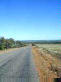
Still a nice day for riding so decided to continue on to the next farm
town southwards, Three Springs, 53 km further. Road was considerably
quieter than the Brand Highway I had taken northbound. Stands of trees
along the way, but behind the fields also a railroad line. Less hills than
before Mingenew.
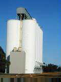
Reached Three Springs at end of a long day. This town was remarkably
quiet with a giant grain elevator, railroad, old hotel, supermarket, general
store, red cross store, post office, supermarket, general store and a few other
stores. Nice to be heading anti-clockwise again!
158 km today, 15487 km cumulative.
September 5th; Three Springs to Moora
 Another
day of quiet riding through farming country. Two storm fronts are coming
in the next days, though it stayed dry until the last 5 km when it briefly
poured. Three Springs gets about half the annual precipitation of Perth,
storms don't always make it inland. In the past month, I've observed most
rain in the SW corner and coming across the bottom of WA...so may have some wet
riding ahead. This has been a drought year with watering restrictions in
Perth and TV reporters standing in parched wheat fields with news reports.
Another
day of quiet riding through farming country. Two storm fronts are coming
in the next days, though it stayed dry until the last 5 km when it briefly
poured. Three Springs gets about half the annual precipitation of Perth,
storms don't always make it inland. In the past month, I've observed most
rain in the SW corner and coming across the bottom of WA...so may have some wet
riding ahead. This has been a drought year with watering restrictions in
Perth and TV reporters standing in parched wheat fields with news reports.
Several small towns today. Carnamah at 23 km, Coorow at 50 km, Watheroo
at 103 km and Moora at 142 km. Moora is the largest town between Geraldton
and Perth and has 1800 people. Most of these towns have large grain
elevator, a row of store fronts, an old hotel, and a new petrol station.
Wheat, canola, sheep pastures were predominant again. Frequently a small
stretch of trees next to the road.
Left Three Springs early and had brief stop in Carnamah and brekky in Coorow.
An older gentleman was standing outside the roadhouse, hitchhiking, but not
having much luck. He asked, "are you riding all the way to
Perth?" I answered, "yes", without bothering to add that
plans were a lot further than that...
 First
part of the day had some long gentle rises and descents, particularly between
Coorow and Watheroo. Watheroo was a lunch stop at the railway station that
had been converted into a tavern. Watheroo was smaller than two previous
towns, so kept going.
First
part of the day had some long gentle rises and descents, particularly between
Coorow and Watheroo. Watheroo was a lunch stop at the railway station that
had been converted into a tavern. Watheroo was smaller than two previous
towns, so kept going.
Cross winds picked up in the afternoon and were particularly strong the last
15 km. I got within 5 km before the rain came. Gave me good
incentive to find a place at the old hotel. Carefully brought my bike
inside and upstairs.
142 km today, 15629 km cumulative.
September 6th; Moora to Bindoon
 Calm
before the storm...or between storms. Last night, I could hear periodic
rain bursts on the tin roof outside and then quiet again. This morning, I
got my better rain coat and also repacked sensitive computer parts in extra
trash bags and others in ziplock bags.
Calm
before the storm...or between storms. Last night, I could hear periodic
rain bursts on the tin roof outside and then quiet again. This morning, I
got my better rain coat and also repacked sensitive computer parts in extra
trash bags and others in ziplock bags.
Dry when I started, but light sprinkles about five km further. This
started a pattern that repeated five or six times this mornings. It would
rain, sometimes heavily, then, just as quickly, it would dry up again and the
sun would come out. Saw three or four rainbows that way.
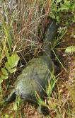
First sixty km were mostly flat as the route followed the railroad
tracks. At sixty km there was a turtle sitting on the stripe in the middle
of the road. A truck passed and legs and head went back into the
shell. I turned back and helped shepard him off the road. Surprising
how fast his feet could carry him once he decided to leave.
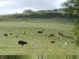
Nice farming country with a few more cows in proportion to sheep today.
Weather forecast carried a "warning for sheep farmers". Not
certain why, but it also included possibilities of hail and thunderstorms.
 After
60 km, the railroad left and the terrain became much hillier. Some citrus
trees along the way. The road climbed up one hill and then would quickly
descend the other side. Intermittent showers continued.
After
60 km, the railroad left and the terrain became much hillier. Some citrus
trees along the way. The road climbed up one hill and then would quickly
descend the other side. Intermittent showers continued.
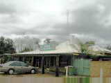
At 82 km, came a turnoff to Gin Gin and also a shift in weather. Heavy
downpour. Winds had slowly been picking up and were now strong from the
side. I slowly road through the wind and rain. Another 4 km and the
road came to a junction with Great Northern Highway. It was a
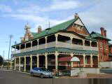
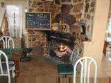
welcome sight to see a country inn right past the intersection.
Although only 11:20am and the inn didn't open until noon, I went under the
eaves to drip off and wait for it to open. The owner saw me outside and
let me and bicycle in to dry off. I decided this was enough for the day
and would let the storm blow through.
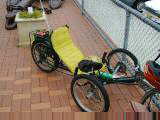
There was a nice fire to warm up. About 1:30pm, in squished two more
cyclists. It was Rod and Gwen, the couple from New South Wales that I had
first met on July 15th and gotten this
photo. We had fun drying by the fire and catching up on things.
Outside the rain stopped later in the afternoon, though a strong south wind was
still blowing.
86 km today, 15715 km cumulative.
September 7th; Bindoon to Rottnest Island
 Stage
two complete! Made it through Perth today. Overcast skies all
morning, but fortunately mostly dry today. Progressively more traffic,
particularly between Midland and Freemantle. Cities take a bit of
concentration, so nice to be on the other side of Perth.
Stage
two complete! Made it through Perth today. Overcast skies all
morning, but fortunately mostly dry today. Progressively more traffic,
particularly between Midland and Freemantle. Cities take a bit of
concentration, so nice to be on the other side of Perth.
A cool morning as I left Bindoon. More road trains today as I was on
the Great Northern Highway again. A few hills until Muchea and then
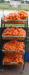
flatter. Some mandarin oranges, some vineyards and some pastures along the
way. Made a brief stop in Muchea and then I was in territory that I'd
ridden eight days before.
Rode back past Bullsbrook and Midland, stopping briefly at Guildford Bike
Shop. In total, came past five bike shops today, a big contrast with the
outback. Guildford bike shop suggested Guildford Road (#51) and then
Stirling Highway (#5) as routes through town. The Guildford Road had some
bicycle sidewalks designated, but they were incomplete, bumpy and out of view of
cross traffic. Hence I ended back on the road again. Traffic was
mostly polite though one car had a "do you want to get killed?" when I
delayed him slightly. At next light he stopped and then dropped his
cigarette butt out the window. Was strongly tempted to toss the butt back
in the open window, but kept my cool...
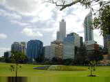
Several small hills to climb over. The last hill was the railroad
tracks and I was in downtown Perth. Several skyscrapers but still a
compact downtown. Perth is known as the "City of Light".
Story goes that in 1962 when John Glenn was orbiting over Australia, folks in
Perth all turned on their lights. Given Perth's isolation as a city, the
contrast between a lighted city and the dark areas allowed Glenn to see Perth
from orbit.
 Took
a little bit of time wandering through Perth. Passed the Royal Mint and
also a pedestrian mall on Hay Street before riding back to the Swan River.
Followed the bike path along the river (much better!), and stopped again at
Western Australia University. By then I was heading
"outbound". As cities go, Perth isn't too bad to cross,
particularly compared to US cities of similar population. I'm sure there
is more to see here, but can do the city walks on another trip.
Took
a little bit of time wandering through Perth. Passed the Royal Mint and
also a pedestrian mall on Hay Street before riding back to the Swan River.
Followed the bike path along the river (much better!), and stopped again at
Western Australia University. By then I was heading
"outbound". As cities go, Perth isn't too bad to cross,
particularly compared to US cities of similar population. I'm sure there
is more to see here, but can do the city walks on another trip.
Map 27
Decided I'd continue to Freemantle and the port. Back on the main road
and over a few hills. Route was roughly following the railroad
tracks. Finally crossed over the Swan River and was in Freemantle.
Followed signs to Victoria Quay and then further to the Rottnest Express
ferry. I had to take off all my gear from the bike and have them load it
separately.
Rottnest Island is an 11 km by 4.5 km island just of the coast. Bicycle
travel is a primary mode of transport. The high speed ferry took 30
minutes to travel to the island (ferrys from Perth take 90 minutes). Went
to the accommodation office and got a small cabin for two nights. Tomorrow
a day to explore the island and otherwise relax.
107 km today, 15822 km cumulative.
September 8th; Rest day on Rottnest Island
 Today
a day to explore Rottnest Island (map).
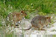
The island is home to about 10,000 quokkas. Quokkas are about size of a
small cat, have pointy snout like a mouse and hop on hind legs like a
wallaby. Indeed, they are most closely related to wallabys.
Today
a day to explore Rottnest Island (map).
The island is home to about 10,000 quokkas. Quokkas are about size of a
small cat, have pointy snout like a mouse and hop on hind legs like a
wallaby. Indeed, they are most closely related to wallabys.
The island was discovered by Dutch explorer Willem de Vlamingh. He
named it "rats' nest" after mistaking quokkas for rats. Robert
Thompson started farming here in 1831. The island was used as a jail for
aboriginals starting in 1838. Over 3000 were imprisoned here and over 300
died, mainly due to pneumonia or diseases. Many of the aboriginal
prisoners were from further north and thus warmer climates. Prison labor
built many of the original buildings and set a distinct style.

 The
prison closed in 1903. Since then, the island has been a popular
recreation spot, particularly for those in WA. Even before 1903, governors
from WA would vacation here. The land and all the buildings are still
owned by the government and leased or hired as appropriate.
The
prison closed in 1903. Since then, the island has been a popular
recreation spot, particularly for those in WA. Even before 1903, governors
from WA would vacation here. The land and all the buildings are still
owned by the government and leased or hired as appropriate.
Before brekky, I got up and bicycled around the island. The western
tip, Cape Vlamingh, had nice views of waves crashing on rocky shores.
Along the way, several small bays, frequently with crayfish pots. There
was a nice lighthouse on the highest point (82m) that afforded views of the
small sandy island. Off in the distance, one could see Perth skyscrapers.
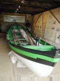
I took a history tour. We walked past many of the original buildings
designed by Henry Vincent and built with prison labor. We also saw the
quod (old prison), an old chapel, a boat house, and other buildings. For a
while, Rottnest was site of a pilot service that ships could use to help guide
them past the reefs and into Freemantle harbor. Use of this service
dramatically increased in 1895 after gold was discovered in WA.
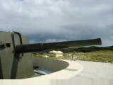 In
the afternoon, I took a short train ride up to Oliver Hill. This location
housed two 9.2 inch guns that had been installed as coastal fortifications in
the 1930s and manned during WW2. The island had also held radar
installations. Had an interesting tour through the guns and chambers and
tunnels underneath.
In
the afternoon, I took a short train ride up to Oliver Hill. This location
housed two 9.2 inch guns that had been installed as coastal fortifications in
the 1930s and manned during WW2. The island had also held radar
installations. Had an interesting tour through the guns and chambers and
tunnels underneath.
Otherwise walked around and saw a bit of the island. In addition to
quokkas, also pheasants, peacocks and gulls. I can see why this would be a
popular getaway island. A lack of cars and many bicycles out also give a
flavor of a vacation island. Weather cooperated today with overcast skies
and almost no rain.
23 km today, 15845 km cumulative.
September 9th; Rottnest Island to Rockingham

 A
short ride today to Rockingham. Rain and winds beating on cabin overnight,
but fortunately drier today than was forecast. Packed everything up, had
brekky and made my way back for a mid-morning ferry.
A
short ride today to Rockingham. Rain and winds beating on cabin overnight,
but fortunately drier today than was forecast. Packed everything up, had
brekky and made my way back for a mid-morning ferry.
Large swells on the ocean. Water splashing up to upper deck windows on
the boat and also salt water soaking my bicycle out front. Fortunately,
all looked well as I repacked gear.
In Freemantle met with Andrew
and Joanne. They are planning an extended ride on recumbent trikes
through Australia, starting November 1st. Andrew appears in photo
310 and had contacted me before. They were in Freemantle at a brunch
with the recumbent cyclist group. I had tea with the crew before setting
off.
 Strong
winds from SW and thus head winds for most of the way down. First few kms
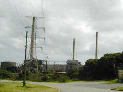
through urban Freemantle and then along the coast. The route passed two
oil refineries, two aluminum refineries, a nickel refinery, a navy industrial
area and other industrial areas. Initially highway 12 was one lane each
way with a few slight hills. Passed a blockage at 13.5 km. Highway 1
was two lanes and a bit more traffic.
Strong
winds from SW and thus head winds for most of the way down. First few kms
through urban Freemantle and then along the coast. The route passed two
oil refineries, two aluminum refineries, a nickel refinery, a navy industrial
area and other industrial areas. Initially highway 12 was one lane each
way with a few slight hills. Passed a blockage at 13.5 km. Highway 1
was two lanes and a bit more traffic.
Slow against the wind, but I soon came to the Rockingham sign (population
78000) and then to Andrew and Joanne's place. Nice talking about cycle
tours and respective plans from here. Had a good pasta dinner and stayed
overnight with Andrew and Joanne.
36 km today, 15881 km cumulative.
September 10th; Rockingham to Bunbury
 I
took off early, Andrew and Joanne were up to see me off. A brief rain
shower just as I left. Saw a nice double rainbow and then it was dry for
the rest of the day.
I
took off early, Andrew and Joanne were up to see me off. A brief rain
shower just as I left. Saw a nice double rainbow and then it was dry for
the rest of the day.
Most of the route today was on a double lane highway. Moderate amount
of traffic until Mandurah and quieter thereafter. Still quite a few petrol
stations and cafes along the way. Feels like a more populated area than
further north.
Around Mandurah and somewhat south, many signs for land and homes for
sale. Looks like a cross between weekender homes for the Perth area and
permanent residences. Reached Mandurah at 30 km, a nuclear free zone,
whatever that means. Highway went around the city, but still somewhat
busy. South of there are several inland lakes and also canal homes.
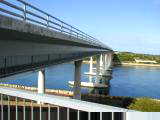
At Dawesville is a huge canal that has been cut to connect the inland lakes with
the sea. Crossed over the pedestrian lanes here before getting back on
traffic lanes.
 Next
stretch was wooded. Fortunate since there were light SW head winds.
The road went past Lake Clifton and Lake Preston. These were apparent from
signage, but not otherwise visible. Stopped at 90 km for a lunch break and
then continued southbound.
Next
stretch was wooded. Fortunate since there were light SW head winds.
The road went past Lake Clifton and Lake Preston. These were apparent from
signage, but not otherwise visible. Stopped at 90 km for a lunch break and
then continued southbound.
At 113 km, a turnoff to Australind. I took this since it also promised
to be the scenic back route to Bunbury, though it returned back to route 1 in
about 15 km. Crossed through large roundabout and then last few kms into
city center for Bunbury.
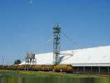
Bunbury is a fair sized town of 22000 people. Nice downtown area with
many restaurants to choose from. Also large cinema and entertainment
hall. I've started to see log trucks, sawdust and other signs of the
timber industry. Bunbury port also has a grain elevator and signs of being
an agricultural center.
131 km today, 16012 km cumulative.