![]() One
Year By Bicycle
One
Year By Bicycle
|
|
|
|
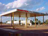
October 11th-20th, 2001October 11th; Rest day in Coober Pedy
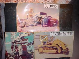
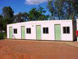
The name Coober Pedy comes from aboriginal for "white man burrowing". It started in 1915 when William Hutchison found the first opals. These opals have attracted people from around the world to find their fortunes. The opal fields are in an area of roughly 80 km by 100 km. For $35 one can stake and register a mining claim of 100m by 50m for 3 months. An individual can only have one claim at a time. There are about 700 active claims, by individuals and not by large corporate mining companies. Once the time expires, someone else can work the claim and pick over it. Current mining technology uses four different types of machines. A boring machine drills vertical shafts about a meter wide. In the opal fields, these holes are typically drilled to a depth of 20m to get to three layers of opals. All over the opal fields there are little piles of dirt next to 20m deep holes. One report I saw said there are about 200,000 holes around Coober Pedy (watch where you walk!). Digging shafts is expensive, so some miners expand from existing claims.
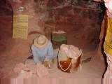
The excess rock is removed from the mine using a blower machine. This is essentially a huge industrial vacuum used to suck up rocks and bring them to the surface out of the way. When excess rocks are gone, one can pick away at the opals. The fourth machine used is called noodling machine. Approximately 90% of the opals are found by the first miner, leaving 10% in the waste heaps. A noodling machine mechanically separates rocks from dirt and then runs the rocks past a UV light where someone can pick out luminescent stones. Our afternoon tour went through opal fields where it was interesting to see many small piles of dirt next to deep holes everywhere. I also visited the Old Timers Mine and Umoona Mine in the morning where I could see the original processes used before current equipment. Average summer high temperatures are 35°C. Early settlers found mines a cool welcome change. From then a culture of underground buildings has developed and many other establishments are underground.
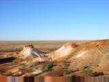
I also saw Digger's Dream home in the morning and another home in the afternoon. These showed a modern version of the underground home. Walls are square since they are built with tunneling machines. Kitchens, bathrooms and other waste water generation is on outside with large spacious rooms inside. Above the home stick various ventilation shafts, TV aerials, etc. All looked quite nice and typical prices of $AUS 100,000 affordable. I thought the Old Timers Mine is one of the best sights in Coober Pedy. The original mine was dug in 1916 and lay covered until 1968 when someone digging a bedroom for their daughter, broke into the old mine. There is a museum below to explore old mine tunnels, see part of the old home and also see museum artifacts from town. In the morning, I stopped at the small underground Catholic Church. In the afternoon, I saw a very impressive Serbian Orthodox Church. It had a high roof with stained glass windows that made it quite impressive. I climbed a few lookouts over town including The Big Winch. This was one of the more prominent points in town and one could see how many homes were burrowed into sides of hills. I stopped through small shop here, a bookshop, pottery store and a few other places in town. Our afternoon tour took us out to The Breakaways. This is a colored mesa region north of town with some dramatic scenery. Films such as Mad Max have been filmed here. Also in town were props from some other movies. Nice views out in the Breakaways. Also in this area was the dingo fence again. Overall, I found Coober Pedy to be an interesting and intriguing place to
explore. October 12th; Coober Pedy to Cadney Park Homestead
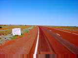
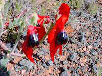
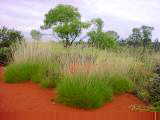
The first 35 km went past opal fields. Early morning sunrise accented the tailings piles. After 22 km was a turnoff to the Breakaways. At 42 km I crossed the dingo fence. This is a continuation of the same fence I crossed at Yalata. Overall it is longer than 5000 km. There is a person in Coober Pedy whose job is to maintain 300 km of fence. Each week he rides his portion of fence. It takes him three slabs (cases) of beer in completing a 300 km run. After leaving the opal fields, the terrain stayed open before starting with shrubs around 70 km. This landscape is known as chenopod shrublands or sometimes called shrub steppes. It stretches from Nullarbor Plain north to Alice Springs. Dominant plants include saltbush and bluebush (both blue-grey). The open areas are known as Gibber Plains. There were more wildflowers today. Apparently while Cooper Pedy has annual rainfall of 175 mm, they've had two 25mm storms recently.
After the rest area, the wind slowly shifted to more from the NE and thus a headwind. A few slight hills and more chenopad shrub. My speed slowed as I came to a rest area at 111 km. There was another water tank. This would have been a good place to camp, though I decided to push on to the roadhouse since it was only 42 km away. Definitely slow riding, but made it to Cadney Park Homestead by late
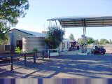
afternoon. Cadney Park roadhouse had a motel, caravan park, pool and restaurant.
It is open 24 hours. The Ghan train stops on Tuesday nights. There is a triple
road train parked out front with cows mooing in the trailers. October 13th; Cadney Park Homestead to Marla
Landscapes were mostly chenopod scrub today. A few gentle hills. I crossed half a dozen cattle grids and also saw about two dozen cows grazing along the road. Saw a wedgetail eagle and a few hawks as well. Made my way fairly quickly and reached Marla before 11 am. From here it is a large gap to the next rest area and water, so decided to make it a short day. Relaxed, read and looked around a bit.
October 14th; Marla to Kulgera
Left Marla early and was on the road before sunrise. After 4 km was a turnoff to Mintabie opal fields (35 km). These are in an aboriginal area and require a permit for access. The road passed a few mesas at 20 km and also at 40 km. Hawks were soaring along the way. At 53 km was a rest area with monument indicating this was the last part of the road to be sealed. This wasn't until 1987, surprisingly recent. Talked briefly with a couple heading home to Alice Springs. At 61 km the road crossed the railroad the last time before Alice Springs. This next section of road had many wildflowers and was a pretty ride. I saw a spikey lizard here and more hawks soaring. I crossed eleven cattle grids today, but didn't see cows until past the last grid.
For two km my bicycle and I herded four cows that decided to run along
instead of away. At 158 km was the Northern Territory border. More display
boards and also a water tank. Signs indicated that live animals and plants were
subject to quarantine. Hooray!, nice to reach NT again. Decided to go the last
21 km from there to Kulgera Roadhouse. A few slight hills and I made it to the
roadhouse. There were motel units, campground, restaurant and police station
here. Out front another road train with mooing cows. October 15th; Kulgera to Mount Ebenezer
Today the first full day riding back in the Northern Territory. I left just as the roadhouse opened. Not much traffic on these roads. A few road trains, tourists in campervans or caravans and occasional cars. The number of caravans has definitely decreased since mid-winter.
Made it to Erldunda Roadhouse just as it started to rain at 11am. Had an extended lunch and relaxed for a while as I decided whether to continue or stop now at 74 km. Erldunda was a major stop with many tourist buses pausing here. Had a large scale cafeteria, motel, fuel pumps and souvenir shop.
October 16th; Mount Ebenezer to Curtin Springs
No traffic for the first hour and a half, after that more cars and buses speeding past. The skies kept getting darker and looking more menacing. I could see lightning strikes in the distance. The next wave of clouds looked menacing enough that I decided I might seek shelter. When first drops of rain hit at 37 km, I quickly set up my tent and pulled gear inside. I was nice and dry as the rain came pounding down. Fairly quickly it stopped. Now unfortunately I had a wet and dirty tent to pack...oh well. At 45 km was a roadside rest area with water tank and shelter. Four km further I met up with another cyclist coming from Ayers Rock. He had started in Broome, ridden via Katherine and then south. He let me know further about Ayers Rock and the Olgas. He had enough rain in the past week to last for a while. As we spoke, another menacing cloud came and passed without a drop. At 77 km was another rest area and at 83 km were view areas for Mount Connor. Seemed to be popular with the tour buses.
After Mount Connor view area a few more kilometers along Mount Connor and then into Curtin Springs at 104 km.
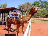
Signs indicate that camel rides are normally available. However it is too
muddy so the camels are out back. Camels were introduced into Central Australia
in 1840 and also were on the Burke and Wills expedition. In 1865 Samuel Stuckey
and Thomas Elder imported 121 camels and 31 "Afghan" handlers into
South Australia. By 1895 there were 6000 camels hauling loads and by 1920 up to
20000 camels. Today while they no longer haul loads, about 30,000 camels run
wild in Central Australia. The strain is pure enough that sometimes they
are exported back to Arabia. I found it interesting to note that camel drivers
used to rest their camels during middle of the day to avoid extreme heat and
flies. Hence, some of these flies I've been getting are perhaps distant
descendants of those bothering the camels 130 years before! October 17th; Curtin Springs to Ayers Rock
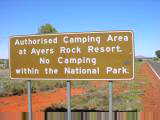
Got my tent dry, though there was another big shower yesterday afternoon. It was followed by a beautiful double rainbow. Yesterday evening my accommodation was across from two women who had come back from Uluru. Morley Grainger (web site: www.morleygrainger.com) is an artist from Towoomba, Queensland. Her art is made from fabric and other materials, typically with an explainatory montage. She has six major exhibitions so far, generally covering Australia themes, e.g. Women in Australia, Men at work, Setbacks...she still owns the work and rents it for display. She had a multimedia CD-ROM that I was able to see the exhibits. Quite interesting, particularly the Australia themes which I've also been learning more about. Clear skies and light tailwinds when I awoke. The parking lot was a maze of puddles, but after that not much water on the road. Soils have been getting redder which contrasts nicely with green plants, usually spinifex grasses, desert oak trees and some flowers. Nice quick riding with one rest area but not many other places to stop. At 50 km I could see Uluru for the first time. Wow! At one point a car stopped, asked me where I was from and got a photo. By 10am, I had ridden the 85 km to Ayers Rock Resort. Signs indicated no bush camping in the park.
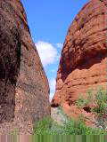
Got lunch and had some more sticker shock at the prices. There was a supermarket with more reasonable prices. After that I booked shuttle bus tickets to get me around the area. I took the Uluru Explorer shuttle out to Kata Tjuta. It was 50 km of fine flat road, but decided to take it easy rather than cycling for a day. Kata Tjuta means "many heads". There are many different tall reddishsandstone/conglomerate mounds several hundred meters high (the tallest is higher than Uluru). Dark streaks stain the rocks where water has run down. Some say Kata Tjuta is more dramatic than Uluru. I can't compare yet. I hiked the Valley of the Winds trail, 8 km that went over and through some wonderful scenery. The shuttle bus gave us three hours though it took me about two hours. After Kata Tjuta, I took the shuttle bus to see sunset over Uluru and then back to the motel. Nice change in colors as the sun went down (more about Uluru tomorrow). Small traffic jam at sunset view area with many coaches and cars. More of the tourists I meet here are of the "Australia in two
weeks" variety. They spend a few days here, a few in Cairns, a few in
Melbourne, a few in Sydney and perhaps one other place and then have "seen
Australia". I'm going on six months and don't make that claim. I've also
been seeing more American and Japanese tourists. I'll have to use the American
equivalents for a few terms I've been using (unsealed roads, bitumin, brekky,
cuppa, "no worries" and pushbike come to mind). October 18th; Rest day at Ayers Rock
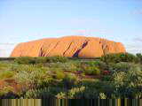
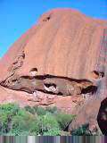
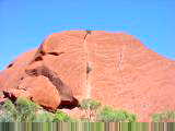
Sunrise was pretty, with subtle changes in color as different light hit. Uluru gets over 400,000 visitors per year (half a million last year with the Olympics). Around now there are typically 1000-2000 people at sunrise and 2000-3000 at sunset. Today was no exception with long rows of buses parked and people eagerly awaiting the sun. Visitor stays average 1.6 days and each visitor pays $16.25 to enter the park (25% of which goes to the aboriginal owners and 75% pays for upkeep of the park). Many visitors come to climb to top of Uluru. There is a 1.6 km route to the 348 meter high summit. Initial parts of the route are very steep with cables afixed. However there is a sign posted that aboriginal owners request people not to climb. Reasons for the request are both because the climb goes on top of sacred paths and because a surprisingly high number of visitors develop problems (e.g. heat stroke, heart attack) which troubles the owners. The climb is also closed when it is rainy, windy or too hot. Here is one site that describes one consideration given on not climbing. It also refers to fuss raised earlier this year when the climb was closed after an important aboriginal elder died. Overall it is a complex issue as the aboriginal groups are also dependent on gate receipts into the park (and in fact earlier this year when Uluru was closed they saw cancellations). I decided to hike around only partially because of concerns above. At least as important for me was that it seemed at least as intriguing. From afar the rock looks like one large monolithic stone. However up close there is a whole variety of weathering, water holes, caves and other features. Different sides have been exposed to different erosion factors (e.g. the north side sees ~35°C temperature swings, the southeast side gets prevailing winds), so some parts are smooth, some with caves, etc. Formation of Uluru itself started ~600 million years ago when sediments were deposited. Kata Tjuta was closer to the eroding mountains so received a coarser conglomerate layer. After these layers were deposited a stage of lifting, faulting and turning raised these rocks. Uluru is one single pillar of unjointed rock (some signs I saw said largest in the world). This lack of jointing meant surrounding areas eroded more quickly. A significant portion of this rock pillar is below the ground. My walk around Uluru was 9 km and took me past this geology. Interesting and well worth the walk. A part way around I joined a ranger walk (the Mala walk). The talk described aboriginal stories of the rock, bush tucker, caves, rock art and other views along part of the rock. From there I continued further around. Occasional caves and indentations were marked as sacred sites with photography prohibited.
After cultural center back to Ayers Rock resort and also a brief stop at the visitor center. Ernest Giles and William Gosse were first Europeans to see the rock in 1873. They named it Ayers Rock after the Secretary General of South Australia. In 1920 the area was made part of an aboriginal reserve. In 1948 a dirt road was constructed and tourism started and the area became a national park in 1958. Aboriginal land claims were lodged and initially dismissed. However in October 1985 the area was turned to aboriginal ownership with a 99 year lease provided back as a park. The area is managed by a board of both aboriginal and non-aboriginal appointees. After the visitor center I looked around the shops and resort areas a bit more. Overall I found Uluru definitely an interesting place to visit. Given the
rock is one of the most recognizable images in Australia (if not the world!), I
had been asking caravaners for a while if it was worth the trip. A near
universal answer was yes, since there was a lot to also see/experience up close.
I'd have to agree. I'd also have to report that while both Kata Tjuta and Uluru
were intriguing, I'd have to give the edge to Uluru as my favorite of the two. October 19th; Ayers Rock resort to Curtin Springs
The camels were out and saddled up waiting for tourists. The person attending them was Mark who had walked across Australia in 1999 with four camels. Said he was saving up for the next trip. The camels were closely tethered and looked gentle. Also a bit curious about people. At Curtin Springs was a motorcyclist with load of gear on his bike. Turns out he had ridden from London through Europe, Turkey, Iran, Pakistan, India, Nepal, Thailand, Malaysia, Singapore and now Australia on his way to Sydney to complete his trip. He had a spare tire with him, though got more than 20,000 km on a tire. My back tire is new since Port Augusta but the front tire is still the same since Threeways about 11,000 km ago. It has now worn through in at least a dozen places. It was also useful to get this motorcyclist perspective on India (generally positive though was occasionally mobbed by dozens of people). Pakistan had been a bit worrysome and Nepal was the most beautiful to ride. Australia was a bit boring and "roads were too good".
Curtin Springs currently has 3500 head of cattle. They could support 8000 or so. Cattle are mustered during cooler months and taken by road train to South Australia. Costs about $75 to ship one cow. The ranch has a surprising diversity of plants, 34 types of grasses, 5 types of mulga, wild figs, wild plums and others as well. Saw cattle, kangaroos, horses and also feral camels that had been shot. A number of bores have been drilled to provide water. There are also salt lakes with a thin layer of salt over a muddy bottom. Towering over most of the ranch is Mount Connor. Most of this mesa has a steep 100+ meter cliff, but backside has a few areas one could climb up. Got some good views of the mountain. It was fun riding over 4WD routes. During the past week, they've had 70 mm of rain, close to the annual average of 80 mm. At one point we got very stuck in the mud. No amount of back and forth would get us out. After fiddling with the winch for a while, Ian ended up digging out the holes. Took about 45 minutes but we were out of the mud. Close to the same time, a saga was playing itself out over CB radio. A tour bus had warning lights come on for pressure of the hydraulic brakes. The station sent someone out to assist and also relayed phone conversations with mechanics at home base. Eventually a separate bus came for passengers and the crippled bus was brought to Curtin Springs. Overall got a better feel for this cattle station and good look around Mount
Connor. Recommend it highly as reasonable price accommodation close to
Uluru. In evening a good dinner back at the roadhouse or "evening tea"
is what I've also heard dinner referred to...meals seem to be named: brekky,
smoko (morning break), lunch, suppa (afternoon break) and tea (dinner). October 20th; Curtin Springs to Mount Ebenezer
Not much traffic early or for the first half of the route. Figure those at Uluru wait to see sunrise before setting off and those in Alice Springs haven't gotten here yet. Throughout the day there must have been 30-40 tour buses of various sizes and companies. This is a popular Alice Springs to Uluru tour route. Saw one group stopped beside the road getting a talk about native plants. Also a number of campervans and some cars. Two or three large road trains carrying ore of some type.
Three tour buses just pulled up with visitors queued for food and also
looking through the Aboriginal art in the gallery. Talked with an Austrian tour
guide who was leading German-speaking tours. It was already mid-afternoon, so I
decided to stop for the day. Overall a slow ride against the wind.
|
|
Unless otherwise specified, this page © Copyright 2001-2002, Mike Vermeulen |
 Today
a rest day to look around Coober Pedy. In the morning I visited attractions in
town. In the afternoon I took a tour with Desert Caves tours. Overall I saw
three underground homes, two mines, two museums, a bookstore, two churches and
several other sights.
Today
a rest day to look around Coober Pedy. In the morning I visited attractions in
town. In the afternoon I took a tour with Desert Caves tours. Overall I saw
three underground homes, two mines, two museums, a bookstore, two churches and
several other sights.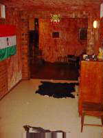
 Once
a vertical shaft is dug and widened, a tunneling machine can be lowered. This
digs horizontally above and below the opal seam. An cheaper alternative to a
tunneling machine is to drill holes and use explosives to blast away the rock.
Throughout town one sees vehicles with "explosives" signs.
Once
a vertical shaft is dug and widened, a tunneling machine can be lowered. This
digs horizontally above and below the opal seam. An cheaper alternative to a
tunneling machine is to drill holes and use explosives to blast away the rock.
Throughout town one sees vehicles with "explosives" signs.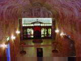
 In
the morning I visited Fayes underground home. The home started as a small two
room structure used by the mailman. Starting thirty years ago, Faye and two
other women used picks and shovels and kept expanding with additional rooms and
now even a swimming pool. It was impressive to see what had been accomplished.
In
the morning I visited Fayes underground home. The home started as a small two
room structure used by the mailman. Starting thirty years ago, Faye and two
other women used picks and shovels and kept expanding with additional rooms and
now even a swimming pool. It was impressive to see what had been accomplished.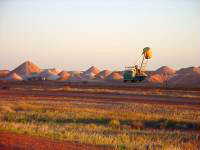
 Today
a long ride, the latter half against a headwind. A flag was lightly blowing in a
SE breeze...right direction!...though mostly calm and quiet when I started.
Stopped briefly at a roadhouse and then to the Stuart Highway and heading
northbound.
Today
a long ride, the latter half against a headwind. A flag was lightly blowing in a
SE breeze...right direction!...though mostly calm and quiet when I started.
Stopped briefly at a roadhouse and then to the Stuart Highway and heading
northbound.
 At
76 km was a rest area where I stopped for a break. A water tank and displays
about early explorers. East of my route is the Oodnadatta track, one of the more
popular outback routes. Between 1891 and 1929, Oodnadatta was the end of the
railway line. Some further transport from there went by camels. The camel
drivers were known as Afghans, though some also came from Iran, India, Turkey
and Egypt.
At
76 km was a rest area where I stopped for a break. A water tank and displays
about early explorers. East of my route is the Oodnadatta track, one of the more
popular outback routes. Between 1891 and 1929, Oodnadatta was the end of the
railway line. Some further transport from there went by camels. The camel
drivers were known as Afghans, though some also came from Iran, India, Turkey
and Egypt.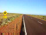
 A
much shorter ride today. Windy though fortunately mostly from the side.
Overnight it rained and some clouds blew through. It was still overcast and
windy from NW when I awoke. Thought uh-oh...but fortunately winds shifted to
west as I left. The clouds also quickly blew off. For the morning gusty winds
shifted to SW, slightly from behind though seemed equivalent to no wind at all.
A
much shorter ride today. Windy though fortunately mostly from the side.
Overnight it rained and some clouds blew through. It was still overcast and
windy from NW when I awoke. Thought uh-oh...but fortunately winds shifted to
west as I left. The clouds also quickly blew off. For the morning gusty winds
shifted to SW, slightly from behind though seemed equivalent to no wind at all.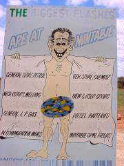
 Marla
was established in 1982, not long after the Ghan railway was rerouted past here
(and thus bypassing Oodnadatta as a regional center). The name Marla comes from
"malu" which is local aboriginal term for "red kangaroo".
This is on edge of the artesian water basin that covers 17% of Australia. There
is a large roadhouse, mini-market, motel, cabin accommodation and restaurant.
The Oodnadatta track ends here and just north of here are turnoffs to the
Mintabie opal fields. During the late 1970s and early 1980s, Mintabie produced
even more opal than Coober Pedy.
Marla
was established in 1982, not long after the Ghan railway was rerouted past here
(and thus bypassing Oodnadatta as a regional center). The name Marla comes from
"malu" which is local aboriginal term for "red kangaroo".
This is on edge of the artesian water basin that covers 17% of Australia. There
is a large roadhouse, mini-market, motel, cabin accommodation and restaurant.
The Oodnadatta track ends here and just north of here are turnoffs to the
Mintabie opal fields. During the late 1970s and early 1980s, Mintabie produced
even more opal than Coober Pedy.
 A
beautiful ride today. Mostly flat and passing through areas with sparse trees.
Many wildflowers along the way, fields of white and yellow but also red and
purple. No clouds and also the first day in a while with almost no wind, just
occasional light breeze from the east.
A
beautiful ride today. Mostly flat and passing through areas with sparse trees.
Many wildflowers along the way, fields of white and yellow but also red and
purple. No clouds and also the first day in a while with almost no wind, just
occasional light breeze from the east.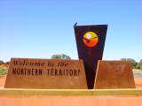
 At
85 km was Agnes Creek rest area and at 120 km was Marryat. The latter had
display boards, emergency phone and water tank. East of here is the Simpson
Desert. It is 150,000 square kilometers and thus larger than England and Wales.
The Simpson Desert is known for having many rows of dunes. Had a late lunch and
talked with couple from Belgium. This had tentatively been my destination for
the day, but with beautiful weather decided to continue.
At
85 km was Agnes Creek rest area and at 120 km was Marryat. The latter had
display boards, emergency phone and water tank. East of here is the Simpson
Desert. It is 150,000 square kilometers and thus larger than England and Wales.
The Simpson Desert is known for having many rows of dunes. Had a late lunch and
talked with couple from Belgium. This had tentatively been my destination for
the day, but with beautiful weather decided to continue.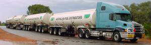 It
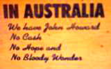
is an election campaign in Australia. The parliament has been dissolved
and a new one is to be elected on November 10th. Last night I watched a
debate between the prime minister and leader of the opposition about whose party
will be better. Many similarities with US debates, though also a bit more
free flowing.
It
is an election campaign in Australia. The parliament has been dissolved
and a new one is to be elected on November 10th. Last night I watched a
debate between the prime minister and leader of the opposition about whose party
will be better. Many similarities with US debates, though also a bit more
free flowing.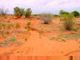 Calm
winds for the first 24 km and then breezes picking up from the east. I saw
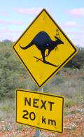
a pair of kangaroos who paused before bouncing away. Also another wedgetail
eagle and a few hawks. The terrain had gradual hills and sparse trees amongst
grasslands. Slow going for a while, but then quicker as I got a few more trees.
Calm
winds for the first 24 km and then breezes picking up from the east. I saw
a pair of kangaroos who paused before bouncing away. Also another wedgetail
eagle and a few hawks. The terrain had gradual hills and sparse trees amongst
grasslands. Slow going for a while, but then quicker as I got a few more trees.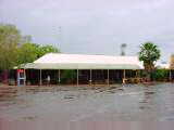 By
1pm it stopped raining and looked reasonable westwards, so I set off on the
Lasseter Highway. Gentle hills continued. My tailwind had mostly disappeared but
after a while the sun came out. More vehicles on the road, though most heading
the other way. Made it to Mount Ebenezer by 3:30 pm and was ready for a stop. A
ten room motel, restaurant, aboriginal art gallery and limited shop to be found
here.
By
1pm it stopped raining and looked reasonable westwards, so I set off on the
Lasseter Highway. Gentle hills continued. My tailwind had mostly disappeared but
after a while the sun came out. More vehicles on the road, though most heading
the other way. Made it to Mount Ebenezer by 3:30 pm and was ready for a stop. A
ten room motel, restaurant, aboriginal art gallery and limited shop to be found
here.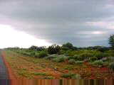
 Unsettled
weather. Last night several showers came through accompanied by rain,wind,
thunder and lightning. This morning there were puddles everywhere but it looked
mostly clear, so set off westwards again. The terrain today had gentle hills
with sparse trees and grasslands. Immediately after Mount Ebenezer was
open range but after 26 km fences along the way to keep cattle from the road.
Unsettled
weather. Last night several showers came through accompanied by rain,wind,
thunder and lightning. This morning there were puddles everywhere but it looked
mostly clear, so set off westwards again. The terrain today had gentle hills
with sparse trees and grasslands. Immediately after Mount Ebenezer was
open range but after 26 km fences along the way to keep cattle from the road.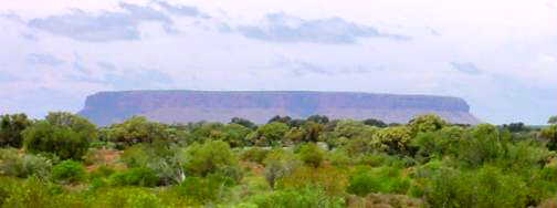 Mount
Connor, Uluru (Ayers Rock) and Kata Tjuta (The Olgas) are three
remnants of an ancient mountain range. Mount Connor is twice the size of Uluru
and four feet higher. However, perhaps not as dramatic. I notice that Uluru
is spelled with an underline under the "r", an interesting
punctuation.
Mount
Connor, Uluru (Ayers Rock) and Kata Tjuta (The Olgas) are three
remnants of an ancient mountain range. Mount Connor is twice the size of Uluru
and four feet higher. However, perhaps not as dramatic. I notice that Uluru
is spelled with an underline under the "r", an interesting
punctuation.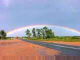 Curtin Springs was first settled by the Andrew family in 1937. It was
originally a 320 km2 grazing station with goats, horses, donkeys and
100 head of cattle. It was originally named Stalin Springs in honor of the
Russian leader. During WW2 it was renamed to Curtin Springs in honor of the
wartime Prime Minister of Australia. The Andrews family sold the homestead in
1958. After that time it became more focused on tourism than grazing.
Curtin Springs was first settled by the Andrew family in 1937. It was
originally a 320 km2 grazing station with goats, horses, donkeys and
100 head of cattle. It was originally named Stalin Springs in honor of the
Russian leader. During WW2 it was renamed to Curtin Springs in honor of the
wartime Prime Minister of Australia. The Andrews family sold the homestead in
1958. After that time it became more focused on tourism than grazing.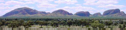
 A
person from Curtin Springs walked with four camels across Australia from April
5th, 1999 to December 31st, 1999. Started at westernmost point (Useless Loop by
Shark Bay, I was there
A
person from Curtin Springs walked with four camels across Australia from April
5th, 1999 to December 31st, 1999. Started at westernmost point (Useless Loop by
Shark Bay, I was there 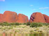
 Stopped
briefly at the visitor center. An attendant asked if he could help with
accommodation choices. First one he quoted was $AUS 340, yikes! I haven't
necessarily done this trip on the cheap, but this was nearly ten times the $AUS
35 I paid at Curtin Springs. Instead I found a shared room for $40 ($37 with my
youth hostel card) and considered myself lucky though I won't be able to park my
bike inside unless I bought four beds which I might do tomorrow night.
Stopped
briefly at the visitor center. An attendant asked if he could help with
accommodation choices. First one he quoted was $AUS 340, yikes! I haven't
necessarily done this trip on the cheap, but this was nearly ten times the $AUS
35 I paid at Curtin Springs. Instead I found a shared room for $40 ($37 with my
youth hostel card) and considered myself lucky though I won't be able to park my
bike inside unless I bought four beds which I might do tomorrow night.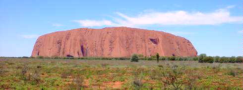
 Rather
than purchase an organized guided tour, I'd picked a less expensive option
($35). Uluru Express operates a shuttle that takes tourists to sunrise viewing,
to next point of choice and then picks them up. This way you can make your own
trip itinerary. I left my bike at hotel to avoid riding in pre-sunrise dark. My
itinerary was to watch sunrise, take a ranger walk/talk, hike one lap around the
rock and end at the cultural center.
Rather
than purchase an organized guided tour, I'd picked a less expensive option
($35). Uluru Express operates a shuttle that takes tourists to sunrise viewing,
to next point of choice and then picks them up. This way you can make your own
trip itinerary. I left my bike at hotel to avoid riding in pre-sunrise dark. My
itinerary was to watch sunrise, take a ranger walk/talk, hike one lap around the
rock and end at the cultural center.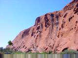
 At
end of my walk I went over to the cultural center with more displays and
stories. One amusing thing I found was a small pile outside labeled
"returned rocks" with a notebook with letters. Several times a week,
Uluru park receives rocks or dirt in the mail. The letters give some of the
reasons. For some it is a belief that the rocks are cursed (one fellow sent a
long letter describing kidney failure, stroke, divorce and other woes). For some
it was a guilt/awareness that this was wrong (legally, ethically). Parents sent
back rocks kids took and friends convince others. Some are returned with short
formal notes and not much explanation.
At
end of my walk I went over to the cultural center with more displays and
stories. One amusing thing I found was a small pile outside labeled
"returned rocks" with a notebook with letters. Several times a week,
Uluru park receives rocks or dirt in the mail. The letters give some of the
reasons. For some it is a belief that the rocks are cursed (one fellow sent a
long letter describing kidney failure, stroke, divorce and other woes). For some
it was a guilt/awareness that this was wrong (legally, ethically). Parents sent
back rocks kids took and friends convince others. Some are returned with short
formal notes and not much explanation.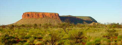
 Light
breezes from the east meant riding was slower than the other direction, but
still made good progress. A little while later, a couple from Belgium passed in
their Britz campervan, stopped and got a video of me riding along. Red soils,
green trees and grass, yellow flowers and clear blue skies along the way. A few
slight hills to cross, but mostly flat. By noon I was back at Curtin Springs.
Light
breezes from the east meant riding was slower than the other direction, but
still made good progress. A little while later, a couple from Belgium passed in
their Britz campervan, stopped and got a video of me riding along. Red soils,
green trees and grass, yellow flowers and clear blue skies along the way. A few
slight hills to cross, but mostly flat. By noon I was back at Curtin Springs.
 Decided
to stay at Curtin Springs and take their half day tour of Mount Connor and of
the ranch. Turned out to be a private tour with Ian Baker the guide and Nicole
someone from Germany working at the station.
Decided
to stay at Curtin Springs and take their half day tour of Mount Connor and of
the ranch. Turned out to be a private tour with Ian Baker the guide and Nicole
someone from Germany working at the station.
 Consistent
headwinds made for slower travel today. Easterly breezes and light clouds right
when I started. Saw a beautiful sunrise with red clouds. Off in the distance was
Mount Connor. Stopped briefly at the Mount Connor overlook at 22 km to rest and
admire the view.
Consistent
headwinds made for slower travel today. Easterly breezes and light clouds right
when I started. Saw a beautiful sunrise with red clouds. Off in the distance was
Mount Connor. Stopped briefly at the Mount Connor overlook at 22 km to rest and
admire the view.
 A
few gentle hills. Paradoxically the uphills were sometimes easier since then the
wind was more blocked. Came to the turnoff to Kings Canyon at 52 km and then
stopped at the next rest area at 60 km. After a welcome rest, rode the last part
to Mount Ebenezer.
A
few gentle hills. Paradoxically the uphills were sometimes easier since then the
wind was more blocked. Came to the turnoff to Kings Canyon at 52 km and then
stopped at the next rest area at 60 km. After a welcome rest, rode the last part
to Mount Ebenezer.